Supermarket nearby Seventh Circle Super Market
Jordan
Supermarket nearby Seventh Circle Super Market
Seventh Circle Super Market
Wadi As-Seir, Amman, Jordan
contacts phone
:
+962
Latitude:
31.9568441
, Longitude:
35.8555069
larger map & directions
read more
nearest Supermarket
107 m
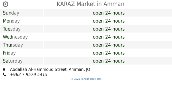
KARAZ Market
Abdallah Al-Hammoud Street, Amman
Supermarket
read more
241 m
Safeway 7th Circle
Princess Sumaya Bint Al-Hassan, Amman
Supermarket
read more
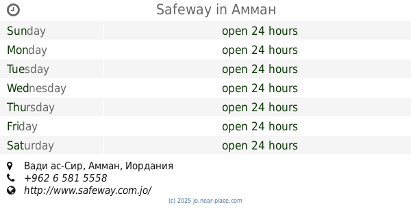
250 m
Safeway
Amman
Supermarket
read more
355 m
تطبيق دكانتي للشراء من السوبر اون لاين
Amman
Supermarket
read more
399 m
HirzAllah Supermarket
عمّان
Supermarket
read more
472 m
Cozmo
Amman
Supermarket
read more
489 m
Happy Family Stores
Shuhada' Al Haram Al Ibrahimi, Amman
Supermarket
read more
503 m
C-Town
Zahran Street 280, Amman
Supermarket
read more
503 m
C-Town
Zahran Street, Amman
Supermarket
read more
510 m
CTown Supermarket
At Tabashir 7, Amman
Supermarket
read more
610 m
Jabra Supermarket
Amman
Supermarket
read more
613 m
Supermarket AMEER LUTFI
Amman
Supermarket
read more
686 m
Rawabi Supermarket
Paris, Amman
Supermarket
read more
701 m
Ard w Talab
Paris, Amman
Supermarket
read more
716 m
المعماري للصناعة والتجارة UPVC
8th Circle, Amman
Supermarket
read more
865 m
SunnyLand Solar
Amman
Supermarket
read more
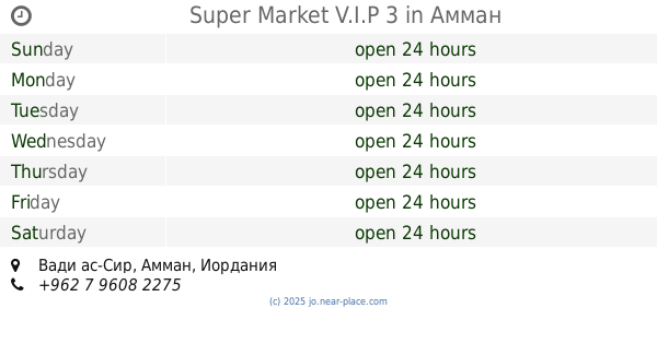
921 m
Super Market V.I.P 3
Amman
Supermarket
read more
942 m
Maher Supermarket سوبر ماركت ماهر
Amman
Supermarket
read more
944 m
Granada Supermarket
الصويفية, Mahmoud Al-Moussa Ubaydat Street, Amman
Supermarket
read more
990 m
Bab Al Faraj
Basima Abd Latif Complex, Ali Nasouh Al Tahir St 19, Amman
Supermarket
read more
1.018 km
Ar Rashed Supermarket
Amman
Supermarket
read more
1.247 km
Cheese and More
Amman
Supermarket
read more
1.315 km
سوبرماركت زيت وزعتر الصويفية Zait &zataar
Naqib Omran Al-Maayetah Street, Amman
Supermarket
read more
1.315 km
سوبرماركت زيت وزعتر الصويفية
Naqib Omran Al-Maayetah Street, Amman
Supermarket
read more
1.827 km
Carrefour - Al Bayader
Amman
Supermarket
read more
📑
all categories
Accounting
Administrative area level 1
Administrative area level 2
Airport
Amusement park
Aquarium
Art gallery
Atm
Bakery
Bank
Bar
Beauty salon
Bicycle store
Book store
Bowling alley
Bus station
Cafe
Campground
Car dealer
Car rental
Car repair
Car wash
Cemetery
Church
City hall
Clothing store
Colloquial area
Convenience store
Country
Courthouse
Dentist
Department store
Doctor
Electrician
Electronics store
Embassy
Finance
Fire station
Florist
Food
Funeral home
Furniture store
Gas station
General contractor
Grocery or supermarket
Gym
Hair care
Hardware store
Health
Home goods store
Hospital
Insurance agency
Jewelry store
Laundry
Lawyer
Library
Liquor store
Local government office
Locality
Locksmith
Lodging
Meal delivery
Meal takeaway
Mosque
Movie rental
Movie theater
Moving company
Museum
Natural feature
Neighborhood
Night club
Painter
Park
Parking
Pet store
Pharmacy
Physiotherapist
Place of worship
Plumber
Point of interest
Police
Post office
Premise
Real estate agency
Restaurant
Route
Rv park, camping
School
Shoe store
Shopping mall
Spa
Stadium
Storage
Store
Supermarket
Taxi stand
Train station
Travel agency
University
Veterinary care
Zoo
sublocality level 1
↑