Supermarket nearby Ar Rashed Supermarket
Jordan
Supermarket nearby Ar Rashed Supermarket
Ar Rashed Supermarket
Амман, Иордания
contacts phone
:
+962 6 585 1222
Latitude:
31.965449
, Longitude:
35.859199
larger map & directions
read more
nearest Supermarket
383 m
SunnyLand Solar
Amman
Supermarket
read more
450 m
Maher Supermarket سوبر ماركت ماهر
Amman
Supermarket
read more
531 m
Happy Family Stores
Shuhada' Al Haram Al Ibrahimi, Amman
Supermarket
read more
539 m
Jabra Supermarket
Amman
Supermarket
read more
550 m
Supermarket AMEER LUTFI
Amman
Supermarket
read more
600 m
C-Town
Zahran Street 280, Amman
Supermarket
read more
600 m
C-Town
Zahran Street, Amman
Supermarket
read more
607 m
CTown Supermarket
At Tabashir 7, Amman
Supermarket
read more
650 m
سلة التسوق
Ahmad Al Dhahlr Street, Amman
Supermarket
read more
752 m
O & O Dukan
Ibrahim Al-Qattan Street, Amman
Supermarket
read more
781 m
O&O Market
Amman
Supermarket
read more
797 m
HirzAllah Supermarket
عمّان
Supermarket
read more
931 m
تطبيق دكانتي للشراء من السوبر اون لاين
Amman
Supermarket
read more
970 m
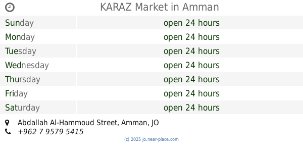
KARAZ Market
Abdallah Al-Hammoud Street, Amman
Supermarket
read more
980 m
Granada Supermarket
الصويفية, Mahmoud Al-Moussa Ubaydat Street, Amman
Supermarket
read more
1.018 km
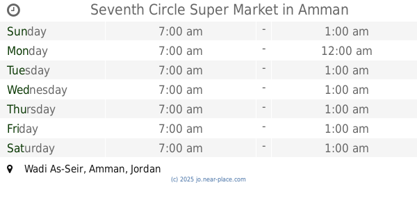
Seventh Circle Super Market
Amman
Supermarket
read more
1.036 km
Bab Al Faraj
Basima Abd Latif Complex, Ali Nasouh Al Tahir St 19, Amman
Supermarket
read more
1.076 km
سوبر ماركت الحلتة
شارع عبد الله غوشة محافظة العاصمة, Amman
Supermarket
read more
1.156 km
Salet el mooneh
Mecca Street, Amman
Supermarket
read more
1.169 km
Fouad Supermarket
Complex No 14, Yaqoub Muammar St 14, Amman
Supermarket
read more
1.222 km
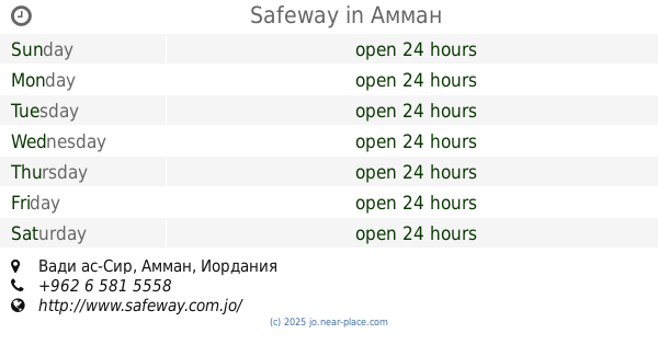
Safeway
Amman
Supermarket
read more
1.303 km
مجوهرات العطاس
Amman
Supermarket
read more
1.306 km
Mollati For Dead Sea Products
Al-Hamra Street, Amman
Supermarket
read more
1.643 km
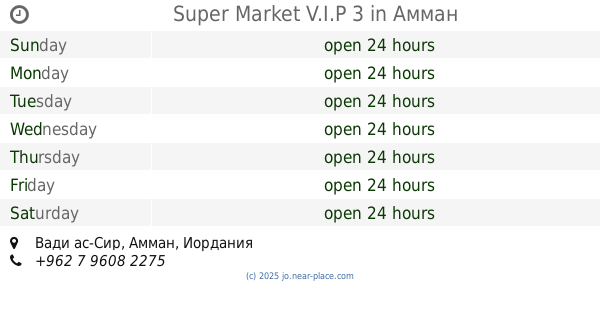
Super Market V.I.P 3
Amman
Supermarket
read more
2.259 km
Essam And Oun Supermarket
Amman
Supermarket
read more
📑
all categories
Accounting
Administrative area level 1
Administrative area level 2
Airport
Amusement park
Aquarium
Art gallery
Atm
Bakery
Bank
Bar
Beauty salon
Bicycle store
Book store
Bowling alley
Bus station
Cafe
Campground
Car dealer
Car rental
Car repair
Car wash
Cemetery
Church
City hall
Clothing store
Colloquial area
Convenience store
Country
Courthouse
Dentist
Department store
Doctor
Electrician
Electronics store
Embassy
Finance
Fire station
Florist
Food
Funeral home
Furniture store
Gas station
General contractor
Grocery or supermarket
Gym
Hair care
Hardware store
Health
Home goods store
Hospital
Insurance agency
Jewelry store
Laundry
Lawyer
Library
Liquor store
Local government office
Locality
Locksmith
Lodging
Meal delivery
Meal takeaway
Mosque
Movie rental
Movie theater
Moving company
Museum
Natural feature
Neighborhood
Night club
Painter
Park
Parking
Pet store
Pharmacy
Physiotherapist
Place of worship
Plumber
Point of interest
Police
Post office
Premise
Real estate agency
Restaurant
Route
Rv park, camping
School
Shoe store
Shopping mall
Spa
Stadium
Storage
Store
Supermarket
Taxi stand
Train station
Travel agency
University
Veterinary care
Zoo
sublocality level 1
↑