School nearby Rabi'a for Girls
Jordan
School nearby Rabi'a for Girls
Rabi'a for Girls
Russayfah, Jordan
contacts phone
:
+962
Latitude:
32.0150173
, Longitude:
36.0549134
larger map & directions
read more
nearest School
106 m
Russayfah High School For Boys
Russayfah
School
read more
154 m
Jabber bin Hyan School for boys
Russayfah
School
read more
407 m
Classical School of Mertial Arts
Russayfah
School
read more
408 m
المدرسة الكلاسيكية للفنون القتالية
Russayfah
School
read more
559 m
School safe girl Wahab
Russayfah
School
read more
561 m
مدرسة براعم الايمان الاسلامية
الرصيفة،
School
read more
561 m
مركز ابوليث لتعليم السواقه
جبل الامير فيصل، الرصيفة،
School
read more
588 m
School Sinan modern educational
Army Street, Russayfah
School
read more
728 m
Yarmouk Secondary School for Girls
Russayfah
School
read more
766 m
Badr Islamic Elementary School
Russayfah
School
read more
799 m
مركز ابو زيد للسواقه
لواء الرصيفة،, Russayfah
School
read more
799 m
مركز ابو زيد لتعليم قياده السيارات
لواء الرصيفة،, Russayfah
School
read more
816 m
Kindergarten School Islamic Horizons
Russayfah
School
read more
910 m
روضة المسبحين الاسلامية
Russayfah
School
read more
945 m
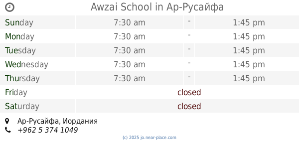
Awzai School
Russayfah
School
read more
967 m
مدرسة ذكور الرصيفة الاعدادية الثالثة
Russayfah
School
read more
980 m
School female junior high Alrsifah
Russayfah
School
read more
1.061 km
مدرسة عاتكة
Russayfah
School
read more
1.069 km
UNRWA schools junior high
Russayfah
School
read more
1.108 km
Zarkas
Russayfah
School
read more
1.192 km
مركز تينا
شارع الملك حسين،, Russayfah
School
read more
1.309 km
مدرسة عائشة بنت ابي بكر الاساسية
Unnamed Road، الرصيفة،
School
read more
1.38 km
مدرسة هند الاساسية للبنات
Russayfah
School
read more
2.06 km
مركز مكاني جمعية الرصيفة للتنمية
لواء الرصيفة،, Russayfah
School
read more
2.167 km
مدرسة فجر الصباح الجبل الشمالي
Russayfah
School
read more
📑
all categories
Accounting
Administrative area level 1
Administrative area level 2
Airport
Amusement park
Aquarium
Art gallery
Atm
Bakery
Bank
Bar
Beauty salon
Bicycle store
Book store
Bowling alley
Bus station
Cafe
Campground
Car dealer
Car rental
Car repair
Car wash
Cemetery
Church
City hall
Clothing store
Colloquial area
Convenience store
Country
Courthouse
Dentist
Department store
Doctor
Electrician
Electronics store
Embassy
Finance
Fire station
Florist
Food
Funeral home
Furniture store
Gas station
General contractor
Grocery or supermarket
Gym
Hair care
Hardware store
Health
Home goods store
Hospital
Insurance agency
Jewelry store
Laundry
Lawyer
Library
Liquor store
Local government office
Locality
Locksmith
Lodging
Meal delivery
Meal takeaway
Mosque
Movie rental
Movie theater
Moving company
Museum
Natural feature
Neighborhood
Night club
Painter
Park
Parking
Pet store
Pharmacy
Physiotherapist
Place of worship
Plumber
Point of interest
Police
Post office
Premise
Real estate agency
Restaurant
Route
Rv park, camping
School
Shoe store
Shopping mall
Spa
Stadium
Storage
Store
Supermarket
Taxi stand
Train station
Travel agency
University
Veterinary care
Zoo
sublocality level 1
↑