School nearby UNRWA schools junior high
Jordan
School nearby UNRWA schools junior high
UNRWA schools junior high
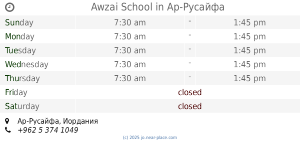
Ар-Русайфа, Иордания
contacts phone
:
+962
Latitude:
32.0146358
, Longitude:
36.0435861
larger map & directions
read more
nearest School
21 m
مدرسة الرصيفة الإعدادية الأولى (ذكور)
Russayfah
School
read more
28 m
مدرسة وكالة الغوث الرصيفة للبنات
Russayfah
School
read more
80 m
Mimouna School for Girls
Russayfah
School
read more
318 m
Rusaifa Secondary School for Girls
Russayfah
School
read more
334 m
مركز تينا
شارع الملك حسين،, Russayfah
School
read more
465 m
مركز ابو زيد لتعليم قياده السيارات
لواء الرصيفة،, Russayfah
School
read more
465 m
مركز ابو زيد للسواقه
لواء الرصيفة،, Russayfah
School
read more
511 m
Awzai School
Russayfah
School
read more
538 m
Schneller Education Academy
King Hussein Street, Russayfah
School
read more
592 m
School safe girl Wahab
Russayfah
School
read more
606 m
مدرسة براعم الايمان الاسلامية
الرصيفة،
School
read more
606 m
مركز ابوليث لتعليم السواقه
جبل الامير فيصل، الرصيفة،
School
read more
651 m
مركز ابو ليث لتعليم السواقه
ش. الملك حسين،، جبل الامير فيصل، الرصيفة،
School
read more
725 m
روضة المسبحين الاسلامية
Russayfah
School
read more
771 m
School Sinan modern educational
Army Street, Russayfah
School
read more
918 m
مدرسة مصعب بن عمير الاساسية للبنين
Russayfah
School
read more
965 m
School female junior high Alrsifah
Russayfah
School
read more
1.003 km
مدرسة ذكور الرصيفة الاعدادية الثالثة
Russayfah
School
read more
1.193 km
Anwar Al Sabah School
Russayfah
School
read more
1.197 km
مدرسة انوار الصباح
Russeifa District, Russayfah
School
read more
1.609 km
مدرسة فجر الصباح الجبل الشمالي
Russayfah
School
read more
1.775 km
Zarkas
Russayfah
School
read more
1.82 km
مركز مكاني جمعية الرصيفة للتنمية
لواء الرصيفة،, Russayfah
School
read more
1.846 km
Rusaifa professional school for girls collected
Az-Zarqa
School
read more
2.346 km
مدرسة طارق بن زياد الأساسية للبنين الرصيفة
Russayfah
School
read more
📑
all categories
Accounting
Administrative area level 1
Administrative area level 2
Airport
Amusement park
Aquarium
Art gallery
Atm
Bakery
Bank
Bar
Beauty salon
Bicycle store
Book store
Bowling alley
Bus station
Cafe
Campground
Car dealer
Car rental
Car repair
Car wash
Cemetery
Church
City hall
Clothing store
Colloquial area
Convenience store
Country
Courthouse
Dentist
Department store
Doctor
Electrician
Electronics store
Embassy
Finance
Fire station
Florist
Food
Funeral home
Furniture store
Gas station
General contractor
Grocery or supermarket
Gym
Hair care
Hardware store
Health
Home goods store
Hospital
Insurance agency
Jewelry store
Laundry
Lawyer
Library
Liquor store
Local government office
Locality
Locksmith
Lodging
Meal delivery
Meal takeaway
Mosque
Movie rental
Movie theater
Moving company
Museum
Natural feature
Neighborhood
Night club
Painter
Park
Parking
Pet store
Pharmacy
Physiotherapist
Place of worship
Plumber
Point of interest
Police
Post office
Premise
Real estate agency
Restaurant
Route
Rv park, camping
School
Shoe store
Shopping mall
Spa
Stadium
Storage
Store
Supermarket
Taxi stand
Train station
Travel agency
University
Veterinary care
Zoo
sublocality level 1
↑