School nearby مكتبة الحسين بن طلال ( المكتبة الحسينية )
Jordan
School nearby مكتبة الحسين بن طلال ( المكتبة الحسينية )
مكتبة الحسين بن طلال ( المكتبة الحسينية )
University Street, Irbid Израиль
contacts phone
:
+962
Latitude:
32.5400588
, Longitude:
35.8579605
read more
nearest School
308 m
مكتبة الجامعة
شارع الأردن, Baghdad
School
read more
424 m
Online Academy
Irbid
School
read more
489 m
حضانة حبايبنا
Irbid
School
read more
507 m
مركز الهلال
Irbid
School
read more
530 m
مدرسة عثمان بن عفان الاساسية للبنين
Irbid
School
read more
574 m
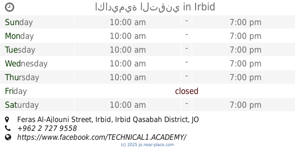
اكاديمية التقني
Feras Al-Ajlouni Street, Irbid
School
read more
603 m
HAMDI
Mujama SH.Khaliil, Irbid
School
read more
678 m
روضة و مدرسة الإيمان التعليمية
Rateb Al-Battayenah Street, Irbid
School
read more
793 m
Abu Bakr Elementary School
Az Zamakhshari, Irbid
School
read more
800 m
مركز منشأ الأجيال
Irbid
School
read more
826 m
المدرسة النموذجية - جامعة اليرموك
Irbid
School
read more
835 m
Nobel Academy for Culture and Science
اربد - شارع الأهرام - غرب البنك العربي الإسلامي (شارع الحصن), Irbid
School
read more
847 m
مدرسة النموذجية
Irbid
School
read more
856 m
مدرسة عبد الرحمن الحلحولي الأساسية للبنين
Irbid
School
read more
951 m
Kindergarten and Elementary School Light
Irbid
School
read more
985 m
حضانة الكتاكيت
Irbid
School
read more
1.002 km
Kindergarten School and son of Educational
Irbid
School
read more
1.005 km
UNRWA - Irbid First Secondary School
Irbid
School
read more
1.012 km
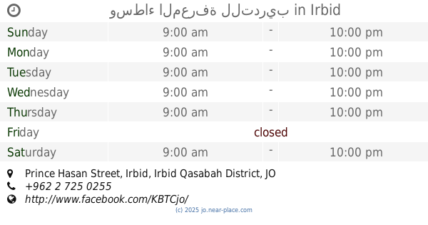
وسطاء المعرفة للتدريب
Prince Hasan Street, Irbid
School
read more
1.044 km
Bahrain Elementary School for Girls
Irbid
School
read more
1.072 km
مدرسة الحسين الأساسية
Irbid
School
read more
1.078 km
مدارس الإرث الذهبي
Irbid
School
read more
1.12 km
مدرسة القادسية الأساسية للبنات
Al Madina Al Munawara, Irbid
School
read more
1.208 km
روضة و اكاديميةيارا التربوية
حي الافراح، إربد،
School
read more
1.336 km
Jordan National School
School
read more
📑
all categories
Accounting
Administrative area level 1
Administrative area level 2
Airport
Amusement park
Aquarium
Art gallery
Atm
Bakery
Bank
Bar
Beauty salon
Bicycle store
Book store
Bowling alley
Bus station
Cafe
Campground
Car dealer
Car rental
Car repair
Car wash
Cemetery
Church
City hall
Clothing store
Colloquial area
Convenience store
Country
Courthouse
Dentist
Department store
Doctor
Electrician
Electronics store
Embassy
Finance
Fire station
Florist
Food
Funeral home
Furniture store
Gas station
General contractor
Grocery or supermarket
Gym
Hair care
Hardware store
Health
Home goods store
Hospital
Insurance agency
Jewelry store
Laundry
Lawyer
Library
Liquor store
Local government office
Locality
Locksmith
Lodging
Meal delivery
Meal takeaway
Mosque
Movie rental
Movie theater
Moving company
Museum
Natural feature
Neighborhood
Night club
Painter
Park
Parking
Pet store
Pharmacy
Physiotherapist
Place of worship
Plumber
Point of interest
Police
Post office
Premise
Real estate agency
Restaurant
Route
Rv park, camping
School
Shoe store
Shopping mall
Spa
Stadium
Storage
Store
Supermarket
Taxi stand
Train station
Travel agency
University
Veterinary care
Zoo
sublocality level 1
↑