School nearby مركز الهلال
Jordan
School nearby مركز الهلال
مركز الهلال
Irbid, Jordania
contacts phone
:
+962
Latitude:
32.5420692
, Longitude:
35.8531037
larger map & directions
read more
nearest School
82 m
حضانة Lucky Baby
Irbid
School
read more
200 m
كلية التربية
شارع الأردن, Baghdad
School
read more
200 m
مكتبة الجامعة
شارع الأردن, Baghdad
School
read more
217 m
اكادمية الفرح للعلوم
Irbid
School
read more
230 m
Native Language Training Academy
University Street, Irbid
School
read more
295 m
مركز منشأ الأجيال
Irbid
School
read more
422 m
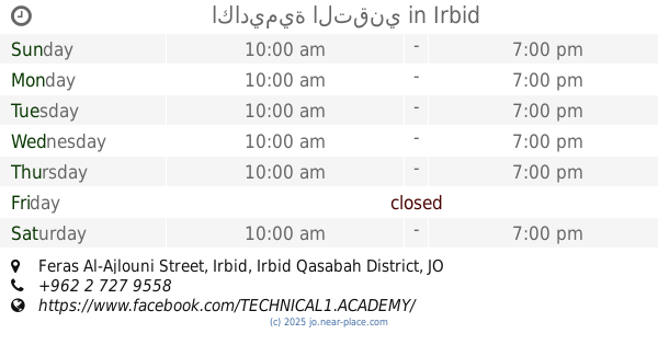
اكاديمية التقني
Feras Al-Ajlouni Street, Irbid
School
read more
461 m
Nobel Academy for Culture and Science
اربد - شارع الأهرام - غرب البنك العربي الإسلامي (شارع الحصن), Irbid
School
read more
502 m
UNRWA - Irbid First Secondary School
Irbid
School
read more
534 m
HAMDI
Mujama SH.Khaliil, Irbid
School
read more
555 m
Kindergarten School and son of Educational
Irbid
School
read more
734 m
روضة و مدرسة الإيمان التعليمية
Rateb Al-Battayenah Street, Irbid
School
read more
759 m
House Science Schools
Irbid
School
read more
768 m
حضانة حبايبنا
Irbid
School
read more
826 m
مدرسة خالد بن الوليد
Irbid
School
read more
898 m
Online Academy
Irbid
School
read more
940 m
مدرسة عثمان بن عفان الاساسية للبنين
Irbid
School
read more
971 m
مدرسة عبد الرحمن الحلحولي الأساسية للبنين
Irbid
School
read more
985 m
Jumanh School
Aydoun
School
read more
1.009 km
المدرسة النموذجية - جامعة اليرموك
Irbid
School
read more
1.031 km
Abu Bakr Elementary School
Az Zamakhshari, Irbid
School
read more
1.034 km
مدرسة رفيده الاسلميه الاساسية للبنات
Areballa Mall Car Parking, جنوب, Abi Al Ala Al Maan, Irbid
School
read more
1.108 km
مدرسة سمخ الابتدائية
Irbid
School
read more
1.121 km
مدرسة سمخ
Irbid
School
read more
1.15 km
مدرسة وروضة اكاديمية اصرار التعليمية
Az-Zehrawi St, Irbid
School
read more
📑
all categories
Accounting
Administrative area level 1
Administrative area level 2
Airport
Amusement park
Aquarium
Art gallery
Atm
Bakery
Bank
Bar
Beauty salon
Bicycle store
Book store
Bowling alley
Bus station
Cafe
Campground
Car dealer
Car rental
Car repair
Car wash
Cemetery
Church
City hall
Clothing store
Colloquial area
Convenience store
Country
Courthouse
Dentist
Department store
Doctor
Electrician
Electronics store
Embassy
Finance
Fire station
Florist
Food
Funeral home
Furniture store
Gas station
General contractor
Grocery or supermarket
Gym
Hair care
Hardware store
Health
Home goods store
Hospital
Insurance agency
Jewelry store
Laundry
Lawyer
Library
Liquor store
Local government office
Locality
Locksmith
Lodging
Meal delivery
Meal takeaway
Mosque
Movie rental
Movie theater
Moving company
Museum
Natural feature
Neighborhood
Night club
Painter
Park
Parking
Pet store
Pharmacy
Physiotherapist
Place of worship
Plumber
Point of interest
Police
Post office
Premise
Real estate agency
Restaurant
Route
Rv park, camping
School
Shoe store
Shopping mall
Spa
Stadium
Storage
Store
Supermarket
Taxi stand
Train station
Travel agency
University
Veterinary care
Zoo
sublocality level 1
↑