School nearby مدرسة مقبله الثانويه للبنات
Jordan
School nearby مدرسة مقبله الثانويه للبنات
مدرسة مقبله الثانويه للبنات
Jerash Governorate, ירדן
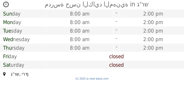
contacts phone
:
+962
Latitude:
32.3180619
, Longitude:
35.8665774
larger map & directions
read more
nearest School
2.057 km
مدرسة ذكور مخيم سوف الابتدائية
Jerash
School
read more
2.09 km
Al Burj Secondary school For Males
School
read more
2.219 km
Community rehabilitation center for the disabled camp will
مخيم سوف, Jerash
School
read more
2.273 km
Compass Educational Academy
Jerash
School
read more
2.584 km
مدرسة نفيسه
Jerash
School
read more
2.653 km
Suf Primary School For Girls
School
read more
2.682 km
Moath Al Kasasbeh Mixed School
Jerash
School
read more
2.687 km
مدرسة سوف الاساسيه للبنات Suf Primary School For Girls
Jerash
School
read more
2.856 km
مدرسة سوف الاساسيه للبنين
Jerash
School
read more
2.87 km
Souf Primary School
Ajloun
School
read more
2.89 km
مدرسة الشيخ يوسف الاساسيه للبنين
Jerash
School
read more
2.903 km
Islamic Nursary
School
read more
2.909 km
Souf secondary school
Ajloun
School
read more
2.911 km
مدرسة سوف الثانوية للبنين
Jerash
School
read more
2.949 km
مدرسة ابواب الجنة النموذجية
Jerash
School
read more
3.004 km
مدرسة دير الليات الثانويه الشامله للبنين
Jerash
School
read more
3.564 km
مدرسة البركتين الاساسية للبنات
Jerash
School
read more
3.989 km
مدرسة الشواهد
Jerash
School
read more
4.66 km
مدرسة كفرخل الثانوية للبنات
School
read more
4.769 km
مدرسة خالد بن الوليد الثانوية للبنين - كفرخل
School
read more
4.984 km
Kindergarten vanguard creators
Jerash
School
read more
5.256 km
Green Mountain School for Girls
Jerash
School
read more
5.565 km
مدرسة حسن الكايد المهنية
Jerash
School
read more
5.566 km
Nusseibeh girl heel
20, Jerash
School
read more
6.178 km
مدرسة عبين عبلين الثانوية للذكور
School
read more
📑
all categories
Accounting
Administrative area level 1
Administrative area level 2
Airport
Amusement park
Aquarium
Art gallery
Atm
Bakery
Bank
Bar
Beauty salon
Bicycle store
Book store
Bowling alley
Bus station
Cafe
Campground
Car dealer
Car rental
Car repair
Car wash
Cemetery
Church
City hall
Clothing store
Colloquial area
Convenience store
Country
Courthouse
Dentist
Department store
Doctor
Electrician
Electronics store
Embassy
Finance
Fire station
Florist
Food
Funeral home
Furniture store
Gas station
General contractor
Grocery or supermarket
Gym
Hair care
Hardware store
Health
Home goods store
Hospital
Insurance agency
Jewelry store
Laundry
Lawyer
Library
Liquor store
Local government office
Locality
Locksmith
Lodging
Meal delivery
Meal takeaway
Mosque
Movie rental
Movie theater
Moving company
Museum
Natural feature
Neighborhood
Night club
Painter
Park
Parking
Pet store
Pharmacy
Physiotherapist
Place of worship
Plumber
Point of interest
Police
Post office
Premise
Real estate agency
Restaurant
Route
Rv park, camping
School
Shoe store
Shopping mall
Spa
Stadium
Storage
Store
Supermarket
Taxi stand
Train station
Travel agency
University
Veterinary care
Zoo
sublocality level 1
↑