School nearby مدرسة كفرخل الاساسية للبنات
Jordan
School nearby مدرسة كفرخل الاساسية للبنات
مدرسة كفرخل الاساسية للبنات
Hizam Ring Road, Amman, Jarash Qasabah District, JO Иордания
contacts phone
:
+962
Latitude:
32.3583537
, Longitude:
35.8789008
larger map & directions
read more
nearest School
549 m
مدرسة خالد بن الوليد الثانوية للبنين
School
read more
566 m
مدرسة كفرخل الثانوية للبنات
School
read more
580 m
مدرسة كفرخل الاساسية للبنين
Kufr Khall
School
read more
580 m
مدرسة خالد بن الوليد - كفرخل
Kufr Khall
School
read more
1.249 km
مدرسة خالد بن الوليد الثانوية للبنين - كفرخل
School
read more
2.782 km
مدرسة ذات النطاقيين
School
read more
3.923 km
مدرسة اسد بن الفرات الثانوية الشاملة - كفرخل
School
read more
3.982 km
مدرسة صقر قريش
School
read more
4.179 km
مدرسة صخرة الثانوية للبنات
School
read more
4.627 km
مدرسة مقبله الثانويه للبنات
School
read more
4.88 km
QAFQAFA SECONDARY GIRLS SCHOOL
Qafqafa
School
read more
5.401 km
Al Burj Secondary school For Males
School
read more
5.642 km
مدرسة عبين عبلين الثانوية للذكور
School
read more
6.195 km
مدرسة نفيسه
Jerash
School
read more
6.376 km
مدرسة ابواب الجنة النموذجية
Jerash
School
read more
6.545 km
Al Shomos School
Jerash
School
read more
6.576 km
Moath Al Kasasbeh Mixed School
Jerash
School
read more
6.601 km
مدرسة جبا الاساسية للبنات
Jerash
School
read more
7.051 km
Naemeh Secondary Comprehensive School for Girls
An-Nuayyimah
School
read more
9.735 km
مدرسة صنعار للبنات
School
read more
12.976 km
مدرسه الملك الناصر
Ajloun
School
read more
14.633 km
Al-Majdal Elementary School
School
read more
14.839 km
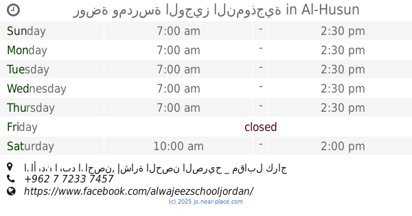
روضة ومدرسة الوجيز النموذجية
الأردن اربد الحصن, إشارة الحصن الصريح _ مقابل كراج القدس _ خلف صالون الأقصى, Al-Husun
School
read more
15.226 km
مدرسة المزار الثانوية للبنين
Al-Mazar As-Samaliyah
School
read more
15.289 km
Jahfieh Secondary Comprehensive Boys School
School
read more
📑
all categories
Accounting
Administrative area level 1
Administrative area level 2
Airport
Amusement park
Aquarium
Art gallery
Atm
Bakery
Bank
Bar
Beauty salon
Bicycle store
Book store
Bowling alley
Bus station
Cafe
Campground
Car dealer
Car rental
Car repair
Car wash
Cemetery
Church
City hall
Clothing store
Colloquial area
Convenience store
Country
Courthouse
Dentist
Department store
Doctor
Electrician
Electronics store
Embassy
Finance
Fire station
Florist
Food
Funeral home
Furniture store
Gas station
General contractor
Grocery or supermarket
Gym
Hair care
Hardware store
Health
Home goods store
Hospital
Insurance agency
Jewelry store
Laundry
Lawyer
Library
Liquor store
Local government office
Locality
Locksmith
Lodging
Meal delivery
Meal takeaway
Mosque
Movie rental
Movie theater
Moving company
Museum
Natural feature
Neighborhood
Night club
Painter
Park
Parking
Pet store
Pharmacy
Physiotherapist
Place of worship
Plumber
Point of interest
Police
Post office
Premise
Real estate agency
Restaurant
Route
Rv park, camping
School
Shoe store
Shopping mall
Spa
Stadium
Storage
Store
Supermarket
Taxi stand
Train station
Travel agency
University
Veterinary care
Zoo
sublocality level 1
↑