School nearby مدرسة ديرعلا الثانوية للبنات
Jordan
School nearby مدرسة ديرعلا الثانوية للبنات
مدرسة ديرعلا الثانوية للبنات
מחוז בלקא, ירדן
contacts phone
:
+962
Latitude:
32.1893855
, Longitude:
35.6285997
larger map & directions
read more
nearest School
233 m
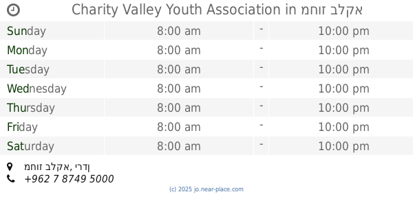
Charity Valley Youth Association
School
read more
254 m
Kindergarten Dome of the Rock
School
read more
287 m
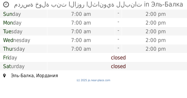
Deir Alla Secondary School for Boys
School
read more
492 m
Deir Alla Elementary School Mixed
School
read more
681 m
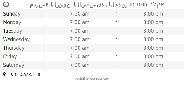
مدرسة ديرعلا الاساسية للبنات
Dayr 'Allah
School
read more
2.118 km
مدرسة الرويحا الاساسية للذكور
School
read more
2.124 km
مدرسة رويحا الاساسية للبنات
School
read more
2.204 km
مدرسة الرويحا الاساسية للاناث
School
read more
2.389 km
مدرسة خولة بنت الازور الثانوية للبنات
School
read more
2.404 km
Dirar bin Azwar School for Boys Secondary Comprehensive
School
read more
3.015 km
مدرسة اروى بنت الحارث الاساسية المختلطة
School
read more
3.265 km
مدرسة بناة العزم
School
read more
3.306 km
مدرسة معدي الثانوية للبنات
School
read more
3.395 km
Directorate of Education Brigade Deir Alla
School
read more
3.804 km
مدرسة ذكور وإناث خزمة / الوكالة
لواء دير علا
School
read more
3.902 km
مدرسة خزما الاساسية للبنين
School
read more
4.333 km
Mdarshh sleepless Southern Girls High School
School
read more
4.409 km
Al-Farouq Secondary
School
read more
4.417 km
مدرسة الفاروق المهنية المجمعة
School
read more
4.474 km
Farouq Secondary School for Boys professional
School
read more
5.988 km
مدرسة البلاونه الاساسية للبنات
School
read more
11.51 km
مدرسة جريش الاساسية المختلطة
Jordan
School
read more
11.992 km
الجامعة الاردنية البحوث الزراعية
School
read more
14.026 km
مدرسه عين البستان
Kufranjah
School
read more
17.862 km
Reading International School
As-Salt
School
read more
📑
all categories
Accounting
Administrative area level 1
Administrative area level 2
Airport
Amusement park
Aquarium
Art gallery
Atm
Bakery
Bank
Bar
Beauty salon
Bicycle store
Book store
Bowling alley
Bus station
Cafe
Campground
Car dealer
Car rental
Car repair
Car wash
Cemetery
Church
City hall
Clothing store
Colloquial area
Convenience store
Country
Courthouse
Dentist
Department store
Doctor
Electrician
Electronics store
Embassy
Finance
Fire station
Florist
Food
Funeral home
Furniture store
Gas station
General contractor
Grocery or supermarket
Gym
Hair care
Hardware store
Health
Home goods store
Hospital
Insurance agency
Jewelry store
Laundry
Lawyer
Library
Liquor store
Local government office
Locality
Locksmith
Lodging
Meal delivery
Meal takeaway
Mosque
Movie rental
Movie theater
Moving company
Museum
Natural feature
Neighborhood
Night club
Painter
Park
Parking
Pet store
Pharmacy
Physiotherapist
Place of worship
Plumber
Point of interest
Police
Post office
Premise
Real estate agency
Restaurant
Route
Rv park, camping
School
Shoe store
Shopping mall
Spa
Stadium
Storage
Store
Supermarket
Taxi stand
Train station
Travel agency
University
Veterinary care
Zoo
sublocality level 1
↑