School nearby الجامعة الاردنية البحوث الزراعية
Jordan
School nearby الجامعة الاردنية البحوث الزراعية
الجامعة الاردنية البحوث الزراعية
Gouvernement al-Balqa, Jordanien
contacts phone
:
+962
Latitude:
32.0852323
, Longitude:
35.5954859
larger map & directions
read more
nearest School
1.917 km
مدرسة
School
read more
2.197 km
Elementary School sand hill mixed
School
read more
8.615 km
Directorate of Education Brigade Deir Alla
School
read more
11.277 km
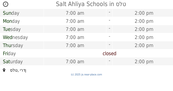
Salt Ahliya Schools
As-Salt
School
read more
12.018 km
مدرسة أديب وهبه الثانوية للبنين
As-Salt
School
read more
12.223 km
مدرسة عبد الحليم النمر
As-Salt
School
read more
12.476 km
Deir Alla Elementary School Mixed
School
read more
12.596 km
مدرسة الحسناء الثانوية للبنات
As-Salt
School
read more
13.021 km
مدرسة السلط الشاملة للبنات
As-Salt
School
read more
13.109 km
Aisha Bint Abi Bakr School
As-Salt
School
read more
13.13 km
مدرسة عائشة بنت ابي بكر الصديق
As-Salt
School
read more
13.348 km
مدرسة يافا الاساسيه المختلطه
As-Salt
School
read more
13.574 km
Reading International School
As-Salt
School
read more
13.733 km
Habit Allah School
As Slat, As-Salt
School
read more
13.88 km
مدرسة رويحا الاساسية للبنات
School
read more
13.958 km
King Abdulla School for Excellence
As-Salt
School
read more
14.021 km
East Bayuda Secondery School for Girls
Jordan
School
read more
14.348 km
مدرسه فاطمه الزهراء
As-Salt
School
read more
14.743 km
مدرسة خالدة القرشية
Unnamed Road, As-Salt
School
read more
14.835 km
Balqa' Islamic School
As-Salt
School
read more
14.995 km
مدرسة الغفران
Balqa
School
read more
15.669 km
Zaid bin Haritha School
School
read more
15.715 km
مدرسة يرقا الثانوية للبنين
School
read more
16.232 km
مدرسة جريش الاساسية المختلطة
Jordan
School
read more
17.62 km
مدرسة المنصورة الثانوية المختلطه
School
read more
📑
all categories
Accounting
Administrative area level 1
Administrative area level 2
Airport
Amusement park
Aquarium
Art gallery
Atm
Bakery
Bank
Bar
Beauty salon
Bicycle store
Book store
Bowling alley
Bus station
Cafe
Campground
Car dealer
Car rental
Car repair
Car wash
Cemetery
Church
City hall
Clothing store
Colloquial area
Convenience store
Country
Courthouse
Dentist
Department store
Doctor
Electrician
Electronics store
Embassy
Finance
Fire station
Florist
Food
Funeral home
Furniture store
Gas station
General contractor
Grocery or supermarket
Gym
Hair care
Hardware store
Health
Home goods store
Hospital
Insurance agency
Jewelry store
Laundry
Lawyer
Library
Liquor store
Local government office
Locality
Locksmith
Lodging
Meal delivery
Meal takeaway
Mosque
Movie rental
Movie theater
Moving company
Museum
Natural feature
Neighborhood
Night club
Painter
Park
Parking
Pet store
Pharmacy
Physiotherapist
Place of worship
Plumber
Point of interest
Police
Post office
Premise
Real estate agency
Restaurant
Route
Rv park, camping
School
Shoe store
Shopping mall
Spa
Stadium
Storage
Store
Supermarket
Taxi stand
Train station
Travel agency
University
Veterinary care
Zoo
sublocality level 1
↑