School nearby مدرسة براعم الاسلام
Jordan
School nearby مدرسة براعم الاسلام
مدرسة براعم الاسلام
מחוז בלקא, ירדן
contacts phone
:
+962
Latitude:
31.9562507
, Longitude:
35.5854749
larger map & directions
read more
nearest School
599 m
School Rabi'a Secondary School for Girls
Karameh
School
read more
742 m
Karameh High School For Boys
Karameh
School
read more
1.299 km
مدرسة ذكور الكرامة الاعدادية
School
read more
1.325 km
School Karama
School
read more
5.765 km
مدرسة السكنة
School
read more
10.528 km
Zaid bin Haritha School
School
read more
10.635 km
مدرسة يرقا الثانوية للبنين
School
read more
11.124 km
Shoonah Government School
School
read more
12.68 km
مدرسة
School
read more
14.371 km
الجامعة الاردنية البحوث الزراعية
School
read more
14.965 km
مدرسة يافا الاساسيه المختلطه
As-Salt
School
read more
15.07 km
مدرسة عبد الحليم النمر
As-Salt
School
read more
15.152 km
مدرسة السلط الشاملة للبنات
As-Salt
School
read more
15.901 km
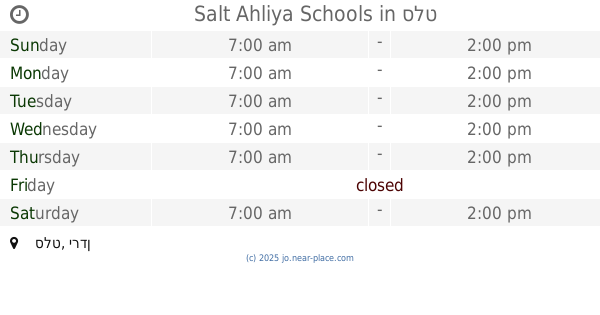
Salt Ahliya Schools
As-Salt
School
read more
16.001 km
مدرسة أديب وهبه الثانوية للبنين
As-Salt
School
read more
16.094 km
مدرسة الروضة الاساسية للبنين
Ar-Rawda
School
read more
16.444 km
مدرسة خالدة القرشية
Unnamed Road, As-Salt
School
read more
16.458 km
مدرسة الحسناء الثانوية للبنات
As-Salt
School
read more
17.171 km
مدرسه فاطمه الزهراء
As-Salt
School
read more
17.19 km
Aisha Bint Abi Bakr School
As-Salt
School
read more
17.194 km
مدرسة عائشة بنت ابي بكر الصديق
As-Salt
School
read more
17.577 km
Abdel Hafez al-Azab School
Prince Hamza Street, As-Salt
School
read more
18.028 km
Reading International School
As-Salt
School
read more
18.329 km
Habit Allah School
As Slat, As-Salt
School
read more
18.422 km
King Abdulla School for Excellence
As-Salt
School
read more
📑
all categories
Accounting
Administrative area level 1
Administrative area level 2
Airport
Amusement park
Aquarium
Art gallery
Atm
Bakery
Bank
Bar
Beauty salon
Bicycle store
Book store
Bowling alley
Bus station
Cafe
Campground
Car dealer
Car rental
Car repair
Car wash
Cemetery
Church
City hall
Clothing store
Colloquial area
Convenience store
Country
Courthouse
Dentist
Department store
Doctor
Electrician
Electronics store
Embassy
Finance
Fire station
Florist
Food
Funeral home
Furniture store
Gas station
General contractor
Grocery or supermarket
Gym
Hair care
Hardware store
Health
Home goods store
Hospital
Insurance agency
Jewelry store
Laundry
Lawyer
Library
Liquor store
Local government office
Locality
Locksmith
Lodging
Meal delivery
Meal takeaway
Mosque
Movie rental
Movie theater
Moving company
Museum
Natural feature
Neighborhood
Night club
Painter
Park
Parking
Pet store
Pharmacy
Physiotherapist
Place of worship
Plumber
Point of interest
Police
Post office
Premise
Real estate agency
Restaurant
Route
Rv park, camping
School
Shoe store
Shopping mall
Spa
Stadium
Storage
Store
Supermarket
Taxi stand
Train station
Travel agency
University
Veterinary care
Zoo
sublocality level 1
↑