School nearby Majdal School Educational
Jordan
School nearby Majdal School Educational
Majdal School Educational
אירביד, ירדן
contacts phone
:
+962
Latitude:
32.5214203
, Longitude:
35.8488356
larger map & directions
read more
nearest School
24 m
روضة أكاديمية اركان السلام
Kaeb Ben Obay Street
School
read more
277 m
روضة زهرة الياسمين
School
read more
294 m
School girl Zainab Apostle Edon
Aydun دوار العيادات سابقا
School
read more
313 m
مدرسة المرساه النموذجية
Al-Hashemi Street
School
read more
345 m
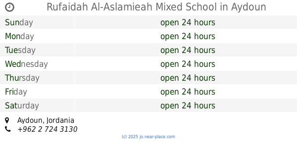
Rufaidah Al-Aslamieah Mixed School
Aydoun
School
read more
350 m
School peaceful Rafidah Mtalth
School
read more
697 m
Kindergarten Abbouda and Hamoudi
منزل السيد محمد بشير فريحات
School
read more
741 m
almuthana
زوم
School
read more
853 m
روضة ومدرسة مصعب بن عمير
Aydoun
School
read more
902 m
Aydoun Basic School for Boys
Aydoun
School
read more
905 m
Taqarob Schools
Irbid
School
read more
925 m
Laurette pedagogical academy
School
read more
967 m
مسجد عبدالله محمود
School
read more
999 m
روضة ثروات الوطن التربوية
Irbid
School
read more
1.021 km
اكاديمية ابجد التعليمية
اربد - ايدون - مقابل مسجد عبدالله الحمود، بناية السلام،
School
read more
1.052 km
professional training Centre
Irbid
School
read more
1.078 km
Dahyat Al hussein Primary School For Boys
Irbid
School
read more
1.123 km
Queen Rania Secondary School for Girls
Irbid
School
read more
1.144 km
Dahyat Al Hussein Secondary School For Girls
Irbid
School
read more
1.155 km
Secondary School for Girls suburb of Al-Hussein
Irbid
School
read more
1.161 km
School district Algosailh Secondary School for Girls
Irbid
School
read more
1.242 km
اكاديمية الرواحل
Irbid
School
read more
1.424 km
Aydoun High School for Girls
Aydoun
School
read more
2.252 km
مدارس الإرث الذهبي
Irbid
School
read more
2.581 km
مجموعة تقارب التعليمية
Prince Hasan Street, Irbid
School
read more
📑
all categories
Accounting
Administrative area level 1
Administrative area level 2
Airport
Amusement park
Aquarium
Art gallery
Atm
Bakery
Bank
Bar
Beauty salon
Bicycle store
Book store
Bowling alley
Bus station
Cafe
Campground
Car dealer
Car rental
Car repair
Car wash
Cemetery
Church
City hall
Clothing store
Colloquial area
Convenience store
Country
Courthouse
Dentist
Department store
Doctor
Electrician
Electronics store
Embassy
Finance
Fire station
Florist
Food
Funeral home
Furniture store
Gas station
General contractor
Grocery or supermarket
Gym
Hair care
Hardware store
Health
Home goods store
Hospital
Insurance agency
Jewelry store
Laundry
Lawyer
Library
Liquor store
Local government office
Locality
Locksmith
Lodging
Meal delivery
Meal takeaway
Mosque
Movie rental
Movie theater
Moving company
Museum
Natural feature
Neighborhood
Night club
Painter
Park
Parking
Pet store
Pharmacy
Physiotherapist
Place of worship
Plumber
Point of interest
Police
Post office
Premise
Real estate agency
Restaurant
Route
Rv park, camping
School
Shoe store
Shopping mall
Spa
Stadium
Storage
Store
Supermarket
Taxi stand
Train station
Travel agency
University
Veterinary care
Zoo
sublocality level 1
↑