School nearby مجموعة تقارب التعليمية
Jordan
School nearby مجموعة تقارب التعليمية
مجموعة تقارب التعليمية
Prince Hasan Street, Irbid, Irbid Qasabah District, JO ירדן
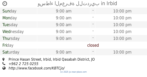
contacts phone
:
+962 7 8832 1321
Latitude:
32.5368974
, Longitude:
35.8693639
larger map & directions
read more
nearest School
36 m
Taqarob Academy
Irbid
School
read more
116 m
وسطاء المعرفة للتدريب
Prince Hasan Street, Irbid
School
read more
222 m
Sago Training & Education
Irbid
School
read more
340 m
مدارس الإرث الذهبي
Irbid
School
read more
614 m
Jordan National School
School
read more
687 m
Custody Success Story
Irbid
School
read more
752 m
Online Academy
Irbid
School
read more
854 m
Hippos Development And Training Center
Wasfi At-Tal St, Irbid
School
read more
879 m
حضانة الكتاكيت
Irbid
School
read more
884 m
Kindergarten and Elementary School Light
Irbid
School
read more
889 m
مدرسة ابن الرومي الأساسية
Irbid
School
read more
935 m
مدرسة النور التربوية الاسلامية
Irbid
School
read more
956 m
مدرسة عثمان بن عفان الاساسية للبنين
Irbid
School
read more
967 m
مدارس تقارب ذكور
Irbid
School
read more
968 m
Kindergarten روضة
Irbid
School
read more
972 m
مجمع اليرموك لتحفيظ القران
Irbid
School
read more
996 m
مدرسة علي خلقي الشرايري الثانوية للبنين
Irbid
School
read more
996 m
مدرسه وروضه المتبقي النموذجيه
Irbid
School
read more
1.057 km
مدرسة خالد بن الوليد
Irbid
School
read more
1.073 km
حضانة حبايبنا
Irbid
School
read more
1.088 km
مدرسة خالد بن الوليد الثانوية للبنين
Irbid
School
read more
1.121 km
School
Al MAlik Husayn, Irbid
School
read more
1.125 km
Abu Bakr Elementary School
Az Zamakhshari, Irbid
School
read more
1.202 km
كلية بنات اربد
Irbid
School
read more
1.22 km
مدرسة أكاديمية الإرشاد الدولية /alershad international academy school
اربد / جنوب جامعة اليرموك /بالقرب من دوار اللوازم, Irbid
School
read more
📑
all categories
Accounting
Administrative area level 1
Administrative area level 2
Airport
Amusement park
Aquarium
Art gallery
Atm
Bakery
Bank
Bar
Beauty salon
Bicycle store
Book store
Bowling alley
Bus station
Cafe
Campground
Car dealer
Car rental
Car repair
Car wash
Cemetery
Church
City hall
Clothing store
Colloquial area
Convenience store
Country
Courthouse
Dentist
Department store
Doctor
Electrician
Electronics store
Embassy
Finance
Fire station
Florist
Food
Funeral home
Furniture store
Gas station
General contractor
Grocery or supermarket
Gym
Hair care
Hardware store
Health
Home goods store
Hospital
Insurance agency
Jewelry store
Laundry
Lawyer
Library
Liquor store
Local government office
Locality
Locksmith
Lodging
Meal delivery
Meal takeaway
Mosque
Movie rental
Movie theater
Moving company
Museum
Natural feature
Neighborhood
Night club
Painter
Park
Parking
Pet store
Pharmacy
Physiotherapist
Place of worship
Plumber
Point of interest
Police
Post office
Premise
Real estate agency
Restaurant
Route
Rv park, camping
School
Shoe store
Shopping mall
Spa
Stadium
Storage
Store
Supermarket
Taxi stand
Train station
Travel agency
University
Veterinary care
Zoo
sublocality level 1
↑