Restaurant nearby مطعم الاخوه
Jordan
Restaurant nearby مطعم الاخوه
مطعم الاخوه
Marj Ben Amir Street, Irbid, Irbid Qasabah District, JO Иордания
contacts phone
:
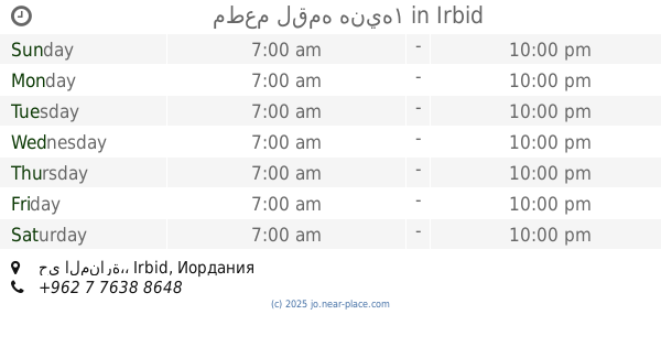
+962
Latitude:
32.5558241
, Longitude:
35.8328362
larger map & directions
read more
nearest Restaurant
98 m
مطعم لقمه هنيه١
حي المنارة،, Irbid
Restaurant
read more
344 m
Restaurant & Grills Kababjee
Irbid
Restaurant
read more
414 m
Bismellah Snackسناكات بسم الله
Irbid
Restaurant
read more
428 m
Abouda Restaurant
شارع فلسطين, Irbid
Restaurant
read more
652 m
Shawarma Tel Hail Restaurant
Irbid
Restaurant
read more
721 m
Sea Waves Restaurant
Irbid
Restaurant
read more
859 m
مطعم لمعلم
Irbid
Restaurant
read more
871 m
مطعم وشاورما البارحة
Irbid
Restaurant
read more
932 m
مطعم ابو طارق
Irbid
Restaurant
read more
1.246 km
مطعم حارتنا
Irbid
Restaurant
read more
1.28 km
مطعم أبو المنذر 2
Irbid
Restaurant
read more
1.332 km
شاورما النغش
10, Irbid
Restaurant
read more
1.448 km
مطعم طلفاح
Al-Hashmi Street, Irbid
Restaurant
read more
1.49 km
Rawas Abu Awwad Restaurant
Wasi At-Tal Square, Irbid
Restaurant
read more
1.563 km
معجنات الباشا
Irbid
Restaurant
read more
1.672 km
مطعم واصف
King Talal Street, Irbid
Restaurant
read more
1.741 km
Oasis Pastry
Irbid
Restaurant
read more
1.768 km
مطعم عبوده 2
غرب دوار مول ب200م, Irbid
Restaurant
read more
1.928 km
مطعم لنا ميزه
Ar-Razi Street, Irbid
Restaurant
read more
1.958 km
مطعم قوزال التركي
Irbid
Restaurant
read more
2.197 km
حلويات وبوظة السيران
Irbid
Restaurant
read more
2.325 km
حلويات الحارة الشامية - اربد
Irbid
Restaurant
read more
2.357 km
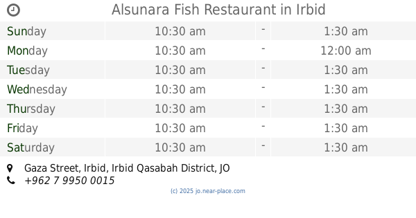
Alsunara Fish Restaurant
Gaza Street, Irbid
Restaurant
read more
2.376 km
مطعم رز و بهار
University Street, Irbid
Restaurant
read more
2.507 km
Shaikh Al Shawarma
Irbid
Restaurant
read more
📑
all categories
Accounting
Administrative area level 1
Administrative area level 2
Airport
Amusement park
Aquarium
Art gallery
Atm
Bakery
Bank
Bar
Beauty salon
Bicycle store
Book store
Bowling alley
Bus station
Cafe
Campground
Car dealer
Car rental
Car repair
Car wash
Cemetery
Church
City hall
Clothing store
Colloquial area
Convenience store
Country
Courthouse
Dentist
Department store
Doctor
Electrician
Electronics store
Embassy
Finance
Fire station
Florist
Food
Funeral home
Furniture store
Gas station
General contractor
Grocery or supermarket
Gym
Hair care
Hardware store
Health
Home goods store
Hospital
Insurance agency
Jewelry store
Laundry
Lawyer
Library
Liquor store
Local government office
Locality
Locksmith
Lodging
Meal delivery
Meal takeaway
Mosque
Movie rental
Movie theater
Moving company
Museum
Natural feature
Neighborhood
Night club
Painter
Park
Parking
Pet store
Pharmacy
Physiotherapist
Place of worship
Plumber
Point of interest
Police
Post office
Premise
Real estate agency
Restaurant
Route
Rv park, camping
School
Shoe store
Shopping mall
Spa
Stadium
Storage
Store
Supermarket
Taxi stand
Train station
Travel agency
University
Veterinary care
Zoo
sublocality level 1
↑