Restaurant nearby حلويات الحارة الشامية - اربد
Jordan
Restaurant nearby حلويات الحارة الشامية - اربد
حلويات الحارة الشامية - اربد
אירביד, ירדן
contacts phone
:
+962 7 9736 2220
website:
www.facebook.com
Latitude:
32.544427
, Longitude:
35.8536347
larger map & directions
read more
nearest Restaurant
273 m
Shaikh Al Shawarma
Irbid
Restaurant
read more
307 m
مطعم المأكولات الصينية الإسلامية
Irbid
Restaurant
read more
331 m
مطعم رز و بهار
University Street, Irbid
Restaurant
read more
349 m
Restaurants Shakereen
اربد-شارع الجامعه-مقابل النادى العربى, Irbid
Restaurant
read more
395 m
معجنات الكردي
Irbid
Restaurant
read more
406 m
Nourgan Restaurant
Irbid
Restaurant
read more
468 m
مطعم امية
Irbid
Restaurant
read more
527 m
مطعم خبرني
Irbid
Restaurant
read more
551 m
قرمش عنا
Irbid
Restaurant
read more
586 m
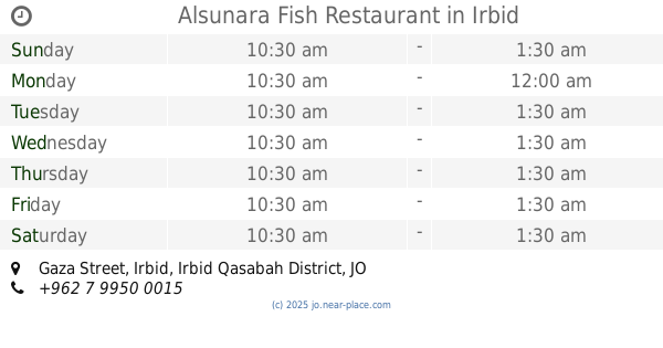
Alsunara Fish Restaurant
Gaza Street, Irbid
Restaurant
read more
653 m
مطعم ع الماشي
Gaza Street, Irbid
Restaurant
read more
696 m
Hungry Snack
Unnamed Road, Irbid
Restaurant
read more
713 m
مطاعم بيت جبري
35, Irbid
Restaurant
read more
726 m
مطعم الرائد
Unnamed Road،, Irbid
Restaurant
read more
729 m
Max Burger
Irbid
Restaurant
read more
747 m
Riachy Restaurant and Gomorrah
Irbid
Restaurant
read more
890 m
Crispy Restaurant
Irbid
Restaurant
read more
894 m
مطعم خان زيد
Al-Basrah Street, Irbid
Restaurant
read more
919 m
Sweets Awabh Homs
مول, Irbid
Restaurant
read more
922 m
مطعم الرائد
Irbid
Restaurant
read more
927 m
Dala'a Karshak Restaurant
Irbid
Restaurant
read more
937 m
Grill makers
Irbid
Restaurant
read more
941 m
Napoli Pizza
Irbid
Restaurant
read more
946 m
مطعم لنا ميزه
Ar-Razi Street, Irbid
Restaurant
read more
1.197 km
Layl & Nhar
مقابل مدينة الحسن الرياضية السلام سنتر ط5
Restaurant
read more
📑
all categories
Accounting
Administrative area level 1
Administrative area level 2
Airport
Amusement park
Aquarium
Art gallery
Atm
Bakery
Bank
Bar
Beauty salon
Bicycle store
Book store
Bowling alley
Bus station
Cafe
Campground
Car dealer
Car rental
Car repair
Car wash
Cemetery
Church
City hall
Clothing store
Colloquial area
Convenience store
Country
Courthouse
Dentist
Department store
Doctor
Electrician
Electronics store
Embassy
Finance
Fire station
Florist
Food
Funeral home
Furniture store
Gas station
General contractor
Grocery or supermarket
Gym
Hair care
Hardware store
Health
Home goods store
Hospital
Insurance agency
Jewelry store
Laundry
Lawyer
Library
Liquor store
Local government office
Locality
Locksmith
Lodging
Meal delivery
Meal takeaway
Mosque
Movie rental
Movie theater
Moving company
Museum
Natural feature
Neighborhood
Night club
Painter
Park
Parking
Pet store
Pharmacy
Physiotherapist
Place of worship
Plumber
Point of interest
Police
Post office
Premise
Real estate agency
Restaurant
Route
Rv park, camping
School
Shoe store
Shopping mall
Spa
Stadium
Storage
Store
Supermarket
Taxi stand
Train station
Travel agency
University
Veterinary care
Zoo
sublocality level 1
↑