Restaurant nearby Emad Abu Njeeleh Resturant
Jordan
Restaurant nearby Emad Abu Njeeleh Resturant
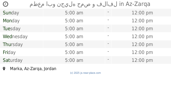
Emad Abu Njeeleh Resturant
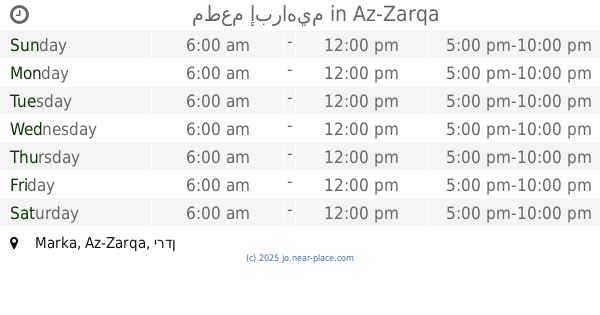
Marka, Az-Zarqa, Jordanien
contacts phone
:
+962
Latitude:
32.0653017
, Longitude:
36.0446367
larger map & directions
read more
nearest Restaurant
6 m
مطعم ابو نجيله حمص و فلافل
Az-Zarqa
Restaurant
read more
985 m
مطعم حمص و فلافل
Az-Zarqa
Restaurant
read more
1.717 km
مطعم حمص وفلافل (شكشوكة)
Az-Zarqa
Restaurant
read more
1.747 km
Queen Recipe Snacks
الجنينه, Az-Zarqa
Restaurant
read more
1.757 km
Atayeb Restaurant
Az-Zarqa
Restaurant
read more
1.91 km
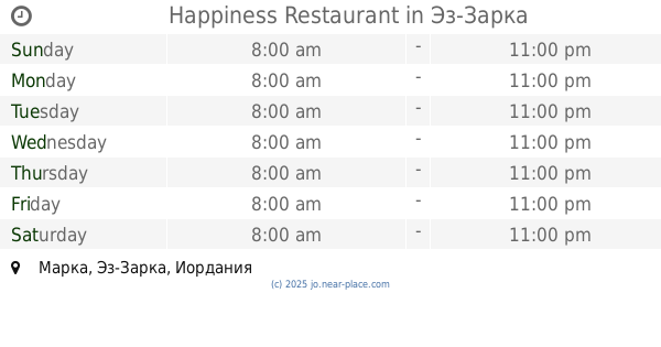
Happiness Restaurant
Az-Zarqa
Restaurant
read more
2.002 km
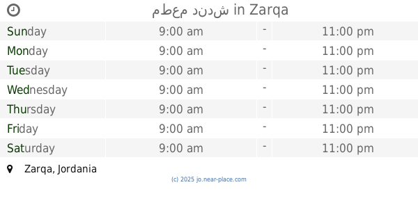
مطعم دندش
Az-Zarqa
Restaurant
read more
2.037 km
The walls of Jerusalem Restaurant roundabout Khamis
Az-Zarqa
Restaurant
read more
2.058 km
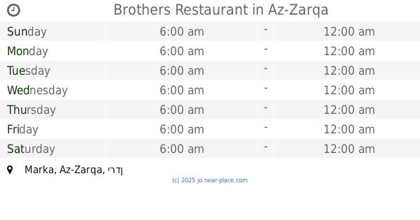
Brothers Restaurant
Az-Zarqa
Restaurant
read more
2.065 km
Abu Stayf Towers Restaurant
حي زواهره مطعم أبراج أبو صطيف
Restaurant
read more
2.246 km
مطعم إبراهيم
Az-Zarqa
Restaurant
read more
2.507 km
مطعم نيروخ
lina alnabulsi, Az-Zarqa
Restaurant
read more
2.57 km
بيت الضيافة للتواصي
Russayfah
Restaurant
read more
2.735 km
مطعم سامر
Az-Zarqa
Restaurant
read more
2.89 km
ملحمة نحله والصباح
الدويك،, Az-Zarqa
Restaurant
read more
2.898 km
ملحمة ومشاوي نحله والصباح
الدويك, Az-Zarqa
Restaurant
read more
2.975 km
Twines Restaurant
حي معصوم شارع المفروشات
Restaurant
read more
3 km
مطعم الزغلوان
لواء الرصيفة،, Russayfah
Restaurant
read more
3.1 km
مطعم عال العال
البساتين،, Az-Zarqa
Restaurant
read more
3.103 km
حلويات القاضي
Az-Zarqa
Restaurant
read more
3.112 km
معجنات عامر
Ma'soum Circle, Az-Zarqa
Restaurant
read more
3.203 km
ملحمه ومشاوي ام القرى
Az-Zarqa
Restaurant
read more
3.203 km
Valley Olive Restaurant
Az-Zarqa
Restaurant
read more
3.436 km
مطاعم عبود
Az-Zarqa
Restaurant
read more
3.455 km
Abboud Cafe and Restaurant
Unnamed Road, حي شارع عماد الدين زنكي, Az-Zarqa
Restaurant
read more
📑
all categories
Accounting
Administrative area level 1
Administrative area level 2
Airport
Amusement park
Aquarium
Art gallery
Atm
Bakery
Bank
Bar
Beauty salon
Bicycle store
Book store
Bowling alley
Bus station
Cafe
Campground
Car dealer
Car rental
Car repair
Car wash
Cemetery
Church
City hall
Clothing store
Colloquial area
Convenience store
Country
Courthouse
Dentist
Department store
Doctor
Electrician
Electronics store
Embassy
Finance
Fire station
Florist
Food
Funeral home
Furniture store
Gas station
General contractor
Grocery or supermarket
Gym
Hair care
Hardware store
Health
Home goods store
Hospital
Insurance agency
Jewelry store
Laundry
Lawyer
Library
Liquor store
Local government office
Locality
Locksmith
Lodging
Meal delivery
Meal takeaway
Mosque
Movie rental
Movie theater
Moving company
Museum
Natural feature
Neighborhood
Night club
Painter
Park
Parking
Pet store
Pharmacy
Physiotherapist
Place of worship
Plumber
Point of interest
Police
Post office
Premise
Real estate agency
Restaurant
Route
Rv park, camping
School
Shoe store
Shopping mall
Spa
Stadium
Storage
Store
Supermarket
Taxi stand
Train station
Travel agency
University
Veterinary care
Zoo
sublocality level 1
↑