Restaurant nearby مطعم عال العال
Jordan
Restaurant nearby مطعم عال العال
مطعم عال العال
البساتين،، Az-Zarqa, Иордания
contacts phone
:
+962 7 8977 5632
Latitude:
32.0774784
, Longitude:
36.0742414
larger map & directions
read more
nearest Restaurant
8 m
حلويات القاضي
Az-Zarqa
Restaurant
read more
80 m
مطعم ريبال
Ma'soum Circle, Az-Zarqa
Restaurant
read more
87 m
معجنات عامر
Ma'soum Circle, Az-Zarqa
Restaurant
read more
109 m
ملحمه ومشاوي ام القرى
Az-Zarqa
Restaurant
read more
137 m
Valley Olive Restaurant
Az-Zarqa
Restaurant
read more
257 m
Twines Restaurant
حي معصوم شارع المفروشات
Restaurant
read more
275 m
Sons of Restaurants Abu Wajih
Az-Zarqa
Restaurant
read more
378 m
parrilla restaurant
Az-Zarqa
Restaurant
read more
416 m
مطعم شاورما ابو الخير
Az-Zarqa
Restaurant
read more
424 m
مطاعم عبود
Az-Zarqa
Restaurant
read more
450 m
Abboud Cafe and Restaurant
Unnamed Road, حي شارع عماد الدين زنكي, Az-Zarqa
Restaurant
read more
683 m
Mexico Snack Restaurant
Az-Zarqa
Restaurant
read more
795 m
مطعم الصباريني
شارع, Az-Zarqa
Restaurant
read more
808 m
مطعم الطيب
Az-Zarqa
Restaurant
read more
950 m
ملحمة ومشاوي الخضراوي
رمزي، الزرقاء،
Restaurant
read more
980 m
مطبخ فروحه
الاردن الزرقاء حي الحسين شارع نسيبه المازنيه عماره رقم, 2
Restaurant
read more
983 m
مطعم ابو عماد الخطاطبه للمناسف
الزرقاء، ش. الهاشمي، الزرقاء،
Restaurant
read more
1.412 km
Queen Recipe Snacks
الجنينه, Az-Zarqa
Restaurant
read more
1.74 km
مصنع بسكوت السلام
Az-Zarqa
Restaurant
read more
1.802 km
مطعم الزهراء
Bab Al-Wad Street, Az-Zarqa
Restaurant
read more
2.093 km
حلويات القاضي
Al-Saadeh Street, Az-Zarqa
Restaurant
read more
2.105 km
Filfila Restaurant
Az-Zarqa
Restaurant
read more
2.118 km
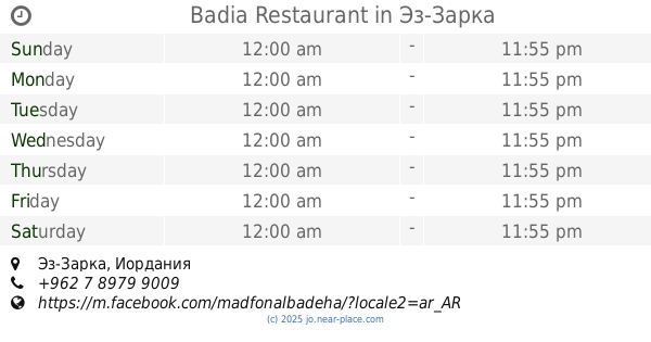
Badia Restaurant
Az-Zarqa
Restaurant
read more
2.15 km
كوكتيل وسناك كوول فروتي
Mecca Street, Az-Zarqa
Restaurant
read more
2.432 km
NAR snack restaurant
Al-Batrwai Circle, Az-Zarqa
Restaurant
read more
📑
all categories
Accounting
Administrative area level 1
Administrative area level 2
Airport
Amusement park
Aquarium
Art gallery
Atm
Bakery
Bank
Bar
Beauty salon
Bicycle store
Book store
Bowling alley
Bus station
Cafe
Campground
Car dealer
Car rental
Car repair
Car wash
Cemetery
Church
City hall
Clothing store
Colloquial area
Convenience store
Country
Courthouse
Dentist
Department store
Doctor
Electrician
Electronics store
Embassy
Finance
Fire station
Florist
Food
Funeral home
Furniture store
Gas station
General contractor
Grocery or supermarket
Gym
Hair care
Hardware store
Health
Home goods store
Hospital
Insurance agency
Jewelry store
Laundry
Lawyer
Library
Liquor store
Local government office
Locality
Locksmith
Lodging
Meal delivery
Meal takeaway
Mosque
Movie rental
Movie theater
Moving company
Museum
Natural feature
Neighborhood
Night club
Painter
Park
Parking
Pet store
Pharmacy
Physiotherapist
Place of worship
Plumber
Point of interest
Police
Post office
Premise
Real estate agency
Restaurant
Route
Rv park, camping
School
Shoe store
Shopping mall
Spa
Stadium
Storage
Store
Supermarket
Taxi stand
Train station
Travel agency
University
Veterinary care
Zoo
sublocality level 1
↑