Point of interest nearby نادي الصريح الرياضي
Jordan
Point of interest nearby نادي الصريح الرياضي
نادي الصريح الرياضي
Irbid Governorate, Иордания
contacts phone
:
+962
Latitude:
32.5036009
, Longitude:
35.9001137
larger map & directions
read more
nearest Point of interest
32 m
Al-Sareeh Youth Center
Point of interest
read more
558 m
منزل عماد العثامنه ابو احمد
As-Sarih
Point of interest
read more
569 m
الكامل للاتصالات
شارع الصريح
Point of interest
read more
792 m
As-Sarih Building Materials Store
As-Sarih
Point of interest
read more
834 m
Zaid Bin Thabit Islamic Center
As-Sarih
Point of interest
read more
874 m
Kamal Water Treatment Plant
As-Sarih
Point of interest
read more
905 m
محطة معرفة الصريح
شارع الملك حسين، الصريح
Point of interest
read more
906 m
بلدية اربد الكبرى - الصريح
As-Sarih Street
Point of interest
read more
963 m
جمعية الإرفاد الخيرية لتنمية الموارد البشرية
Point of interest
read more
976 m
As-Sarih Comprehensive Health Center
As-Sarih
Point of interest
read more
977 m
International Medical Corps Mental (IMC) Alsarih|| الهيئة الطبية الدوليه عيادة الصحة النفسيه - الصريح
Point of interest
read more
1.181 km
فيلا الدكتور محسن عثامنة
As-Sarih
Point of interest
read more
1.424 km
Victory Goods Aluminum
لواء بني عبيد
Point of interest
read more
1.789 km
نادي الطلبة السعوديين اربد
Point of interest
read more
1.811 km
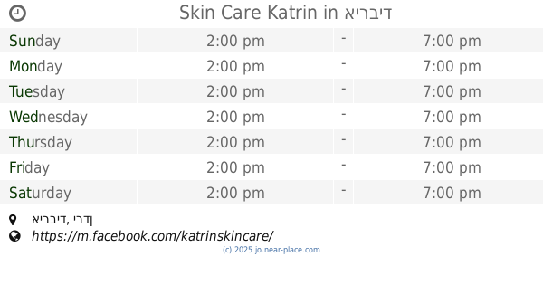
Skin Care Katrin
Point of interest
read more
1.997 km
مكتبة سدين
Point of interest
read more
2.002 km
Al-Husun Club
As-Sarih
Point of interest
read more
2.006 km
Fort Cultural Center
Point of interest
read more
2.053 km
Huson Knowledge Station
As-Sarih
Point of interest
read more
2.075 km
Cooperative Association Rihani
Al-Husun
Point of interest
read more
2.256 km
مركز دجلة التعليمي
Point of interest
read more
2.269 km
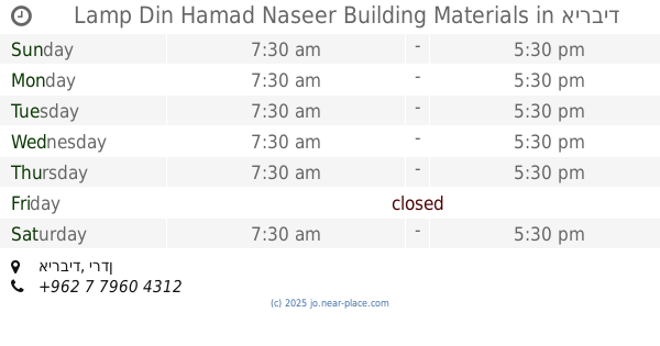
Lamp Din Hamad Naseer Building Materials
Point of interest
read more
2.269 km
Misbah Din Hamad Naseer Building Materials
Point of interest
read more
2.361 km
Civil ESTABLISHMENT
Point of interest
read more
2.845 km
تاكسي الفاروق
Point of interest
read more
📑
all categories
Accounting
Administrative area level 1
Administrative area level 2
Airport
Amusement park
Aquarium
Art gallery
Atm
Bakery
Bank
Bar
Beauty salon
Bicycle store
Book store
Bowling alley
Bus station
Cafe
Campground
Car dealer
Car rental
Car repair
Car wash
Cemetery
Church
City hall
Clothing store
Colloquial area
Convenience store
Country
Courthouse
Dentist
Department store
Doctor
Electrician
Electronics store
Embassy
Finance
Fire station
Florist
Food
Funeral home
Furniture store
Gas station
General contractor
Grocery or supermarket
Gym
Hair care
Hardware store
Health
Home goods store
Hospital
Insurance agency
Jewelry store
Laundry
Lawyer
Library
Liquor store
Local government office
Locality
Locksmith
Lodging
Meal delivery
Meal takeaway
Mosque
Movie rental
Movie theater
Moving company
Museum
Natural feature
Neighborhood
Night club
Painter
Park
Parking
Pet store
Pharmacy
Physiotherapist
Place of worship
Plumber
Point of interest
Police
Post office
Premise
Real estate agency
Restaurant
Route
Rv park, camping
School
Shoe store
Shopping mall
Spa
Stadium
Storage
Store
Supermarket
Taxi stand
Train station
Travel agency
University
Veterinary care
Zoo
sublocality level 1
↑