Point of interest nearby Fort Cultural Center
Jordan
Point of interest nearby Fort Cultural Center
Fort Cultural Center
אירביד, ירדן
contacts phone
:
+962
website:
www.culture.gov.jo
Latitude:
32.4865804
, Longitude:
35.8930163
larger map & directions
read more
nearest Point of interest
13 m
Al-Husun Club
As-Sarih
Point of interest
read more
47 m
Huson Knowledge Station
As-Sarih
Point of interest
read more
130 m
Cooperative Association Rihani
Al-Husun
Point of interest
read more
202 m
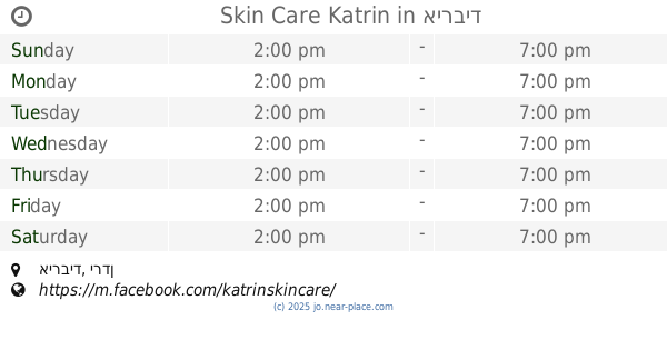
Skin Care Katrin
Point of interest
read more
338 m
مكتبة سدين
Point of interest
read more
773 m
مركز دجلة التعليمي
Point of interest
read more
868 m
الاحوال المدنية
Point of interest
read more
870 m
Civil Status & Passport Department
Point of interest
read more
879 m
الشمال لتجارة و تجهيز الملاعب / معرض الحصن 0796735209
Point of interest
read more
881 m
Bani obaid passport department
Point of interest
read more
926 m
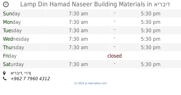
Lamp Din Hamad Naseer Building Materials
Point of interest
read more
926 m
Misbah Din Hamad Naseer Building Materials
Point of interest
read more
927 m
Civil ESTABLISHMENT
Point of interest
read more
1.093 km
Provincial Brigade Bani Obeid
Point of interest
read more
1.14 km
عبد المعين لمواد البناء والكهرباء
Kitim
Point of interest
read more
1.505 km
ديوان عشيرة الوقفي - Alwaqfi Family Club
Point of interest
read more
1.647 km
جمعية الإرفاد الخيرية لتنمية الموارد البشرية
Point of interest
read more
1.748 km
ضيف الله علي المغايرة
الحصن حارة الحفا, Al-Husun
Point of interest
read more
1.838 km
Azmi Al-Mofti Refugee Camp
اربد
Point of interest
read more
1.85 km
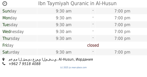
Ibn Taymiyah Quranic
مخيم الشهيد عزمي المفتي, Al-Husun
Point of interest
read more
1.973 km
Al-Sareeh Youth Center
Point of interest
read more
2.006 km
نادي الصريح الرياضي
Point of interest
read more
2.047 km
Opal water desalination plant
Jordan
Point of interest
read more
2.098 km
Education Irbid Second Directorate Brigade Bani Obeid
Point of interest
read more
2.119 km
Al-Karmel SC
Point of interest
read more
📑
all categories
Accounting
Administrative area level 1
Administrative area level 2
Airport
Amusement park
Aquarium
Art gallery
Atm
Bakery
Bank
Bar
Beauty salon
Bicycle store
Book store
Bowling alley
Bus station
Cafe
Campground
Car dealer
Car rental
Car repair
Car wash
Cemetery
Church
City hall
Clothing store
Colloquial area
Convenience store
Country
Courthouse
Dentist
Department store
Doctor
Electrician
Electronics store
Embassy
Finance
Fire station
Florist
Food
Funeral home
Furniture store
Gas station
General contractor
Grocery or supermarket
Gym
Hair care
Hardware store
Health
Home goods store
Hospital
Insurance agency
Jewelry store
Laundry
Lawyer
Library
Liquor store
Local government office
Locality
Locksmith
Lodging
Meal delivery
Meal takeaway
Mosque
Movie rental
Movie theater
Moving company
Museum
Natural feature
Neighborhood
Night club
Painter
Park
Parking
Pet store
Pharmacy
Physiotherapist
Place of worship
Plumber
Point of interest
Police
Post office
Premise
Real estate agency
Restaurant
Route
Rv park, camping
School
Shoe store
Shopping mall
Spa
Stadium
Storage
Store
Supermarket
Taxi stand
Train station
Travel agency
University
Veterinary care
Zoo
sublocality level 1
↑