Pharmacy nearby صيدلية
Jordan
Pharmacy nearby صيدلية
صيدلية
אירביד, ירדן
contacts phone
:
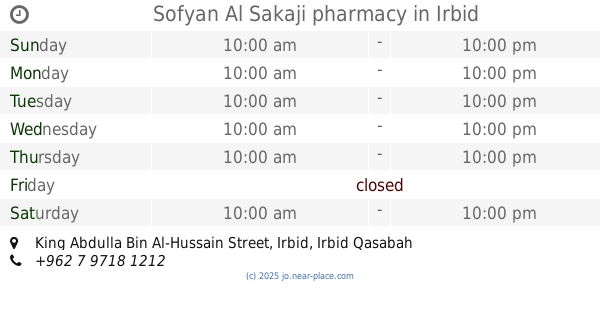
+962
Latitude:
32.5524646
, Longitude:
35.8569868
larger map & directions
read more
nearest Pharmacy
277 m
صيدلية نبيه النابلسي
إربد،
Pharmacy
read more
389 m
صيدلية ذات النطاقين
Al-Fidaa Street, Irbid
Pharmacy
read more
408 m
صيدلية الدكتور معتز - فرع القيروان
شارع راتب البطاينه - صيدلية الدكتور معتز, مقابل سلطة المياه وسوبر ماركت الزيتاوي, بجانب المستشفى الاسلامي من الشمال, Irbid
Pharmacy
read more
420 m
صيدلية سفيان السكجي
Irbid
Pharmacy
read more
426 m
Sofyan Al Sakaji pharmacy
King Abdulla Bin Al-Hussain Street, Irbid
Pharmacy
read more
565 m
Al razi
Irbid
Pharmacy
read more
575 m
Flower Albaloria Pharmacy
Irbid
Pharmacy
read more
641 m
Modern pharmacy - Irbid
Irbid
Pharmacy
read more
648 m
Al-Haditha Pharamcy الصيدلية الحديثة - اربد
Omar Bin Al-Khattab street-Jordanشارع عمر بن الخطاب, Irbid
Pharmacy
read more
653 m
modern pharmacy -Irbidالصيدلية الحديثة - اربد
شارع عمر بن الخطاب, Irbid
Pharmacy
read more
654 m
Pharmacy Lainya
Irbid
Pharmacy
read more
659 m
صيدلية الاناقة
10, Irbid
Pharmacy
read more
682 m
Egyptian Pharmacy
Irbid
Pharmacy
read more
698 m
Shifa pharmacy
Umar Bin Al Khatab, Irbid
Pharmacy
read more
781 m
Lucy Pharmacy Warmia
اربد شارع الثلاثين بجانب مخابز نبيل, Irbid
Pharmacy
read more
781 m
صيدليه معروف
Irbid
Pharmacy
read more
807 m
Dawacom Pharmacy
Unnamed Road, Irbid
Pharmacy
read more
857 m
صيدليه جبارة
Al-Hashmi Street, Irbid
Pharmacy
read more
858 m
Khazer Pharmacy
King Abdulla Bin Al-Hussain Street, Irbid
Pharmacy
read more
913 m
صيدلية عروس الشمال Aroos Alshamal Pharmacy
Feras Al-Ajlouni Street, Irbid
Pharmacy
read more
933 m
صيدلية بلاد الشام البيطرية
King Faysal I Street, Irbid
Pharmacy
read more
985 m
Dawakom Pharmacy
Irbid
Pharmacy
read more
986 m
مركز الحمراء الطبي
شارع السينما،،, Irbid
Pharmacy
read more
1.038 km
Alrazi Pharmacy
Irbid
Pharmacy
read more
1.136 km
صيدلية فانيلا
شارع المدينة المنورة
Pharmacy
read more
📑
all categories
Accounting
Administrative area level 1
Administrative area level 2
Airport
Amusement park
Aquarium
Art gallery
Atm
Bakery
Bank
Bar
Beauty salon
Bicycle store
Book store
Bowling alley
Bus station
Cafe
Campground
Car dealer
Car rental
Car repair
Car wash
Cemetery
Church
City hall
Clothing store
Colloquial area
Convenience store
Country
Courthouse
Dentist
Department store
Doctor
Electrician
Electronics store
Embassy
Finance
Fire station
Florist
Food
Funeral home
Furniture store
Gas station
General contractor
Grocery or supermarket
Gym
Hair care
Hardware store
Health
Home goods store
Hospital
Insurance agency
Jewelry store
Laundry
Lawyer
Library
Liquor store
Local government office
Locality
Locksmith
Lodging
Meal delivery
Meal takeaway
Mosque
Movie rental
Movie theater
Moving company
Museum
Natural feature
Neighborhood
Night club
Painter
Park
Parking
Pet store
Pharmacy
Physiotherapist
Place of worship
Plumber
Point of interest
Police
Post office
Premise
Real estate agency
Restaurant
Route
Rv park, camping
School
Shoe store
Shopping mall
Spa
Stadium
Storage
Store
Supermarket
Taxi stand
Train station
Travel agency
University
Veterinary care
Zoo
sublocality level 1
↑