Grocery or supermarket nearby سوبر ماركت الزيود
Jordan
Grocery or supermarket nearby سوبر ماركت الزيود
سوبر ماركت الزيود
Эз-Зарка, Иордания
contacts phone
:
+962
Latitude:
32.1408235
, Longitude:
36.1081817
larger map & directions
read more
nearest Grocery or supermarket
2 m
Al-Zyoud Gas Super Market
Grocery or supermarket
read more
431 m
سوبر ماركت ابو قيس
Grocery or supermarket
read more
687 m
Noor Grocery Foodstuff
Grocery or supermarket
read more
808 m
Attar / Yousef Bin Wolf Almhakbh
Grocery or supermarket
read more
1.655 km
مني ماركت الشهم
Grocery or supermarket
read more
1.968 km
سوبر ماركت السوبر
Grocery or supermarket
read more
2.033 km
سوبر ماركت الشعلة
Az-Zarqa
Grocery or supermarket
read more
3.806 km
Izzidien Supermarket And Coffee
25
Grocery or supermarket
read more
3.993 km
Abu Hani Grocery
شارع, As-Sukhnah
Grocery or supermarket
read more
4.35 km
المدينة سوبر ماركت
Az-Zarqa
Grocery or supermarket
read more
4.361 km
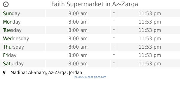
Faith Supermarket
Az-Zarqa
Grocery or supermarket
read more
4.436 km
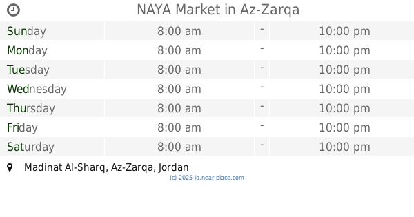
NAYA Market
Az-Zarqa
Grocery or supermarket
read more
4.604 km
Abu Amjad Algoere Grocery
خلف انس مول
Grocery or supermarket
read more
4.716 km
سوبرماركت خالد و جمال Khaled& Jamal Supermarket
Az, Az-Zarqa
Grocery or supermarket
read more
4.863 km
Mix Market
Az-Zarqa
Grocery or supermarket
read more
4.868 km
سوبرماركت البركة
Az-Zarqa
Grocery or supermarket
read more
4.903 km
Wow Market
Az-Zarqa
Grocery or supermarket
read more
4.959 km
3-days Market
Az-Zarqa
Grocery or supermarket
read more
4.993 km
سوبرماركت زمزم
Az-Zarqa
Grocery or supermarket
read more
5.037 km
سوبر ماركت ديما البيك
Unnamed Rd
Grocery or supermarket
read more
5.045 km
Jalal Super Market
Az-Zarqa
Grocery or supermarket
read more
5.103 km
Yahya Mall for Fruits and Vegetables
Army Street, Az-Zarqa
Grocery or supermarket
read more
5.302 km
سوبر ماركت الحوت
Az-Zarqa
Grocery or supermarket
read more
5.33 km
Mega Mart
Az-Zarqa
Grocery or supermarket
read more
5.437 km
Malkawi Grocery
Army Street, Az-Zarqa
Grocery or supermarket
read more
📑
all categories
Accounting
Administrative area level 1
Administrative area level 2
Airport
Amusement park
Aquarium
Art gallery
Atm
Bakery
Bank
Bar
Beauty salon
Bicycle store
Book store
Bowling alley
Bus station
Cafe
Campground
Car dealer
Car rental
Car repair
Car wash
Cemetery
Church
City hall
Clothing store
Colloquial area
Convenience store
Country
Courthouse
Dentist
Department store
Doctor
Electrician
Electronics store
Embassy
Finance
Fire station
Florist
Food
Funeral home
Furniture store
Gas station
General contractor
Grocery or supermarket
Gym
Hair care
Hardware store
Health
Home goods store
Hospital
Insurance agency
Jewelry store
Laundry
Lawyer
Library
Liquor store
Local government office
Locality
Locksmith
Lodging
Meal delivery
Meal takeaway
Mosque
Movie rental
Movie theater
Moving company
Museum
Natural feature
Neighborhood
Night club
Painter
Park
Parking
Pet store
Pharmacy
Physiotherapist
Place of worship
Plumber
Point of interest
Police
Post office
Premise
Real estate agency
Restaurant
Route
Rv park, camping
School
Shoe store
Shopping mall
Spa
Stadium
Storage
Store
Supermarket
Taxi stand
Train station
Travel agency
University
Veterinary care
Zoo
sublocality level 1
↑