Grocery or supermarket nearby سوبر ماركت ابو قيس
Jordan
Grocery or supermarket nearby سوبر ماركت ابو قيس
سوبر ماركت ابو قيس
Zarqa Governorate, Jordan
contacts phone
:
+962
Latitude:
32.1370653
, Longitude:
36.1093177
larger map & directions
read more
nearest Grocery or supermarket
382 m
Attar / Yousef Bin Wolf Almhakbh
Grocery or supermarket
read more
431 m
سوبر ماركت الزيود
Grocery or supermarket
read more
432 m
Al-Zyoud Gas Super Market
Grocery or supermarket
read more
502 m
Noor Grocery Foodstuff
Grocery or supermarket
read more
1.3 km
مني ماركت الشهم
Grocery or supermarket
read more
1.711 km
سوبر ماركت الشعلة
Az-Zarqa
Grocery or supermarket
read more
1.891 km
سوبر ماركت السوبر
Grocery or supermarket
read more
3.93 km
المدينة سوبر ماركت
Az-Zarqa
Grocery or supermarket
read more
4.018 km
Abu Hani Grocery
شارع, As-Sukhnah
Grocery or supermarket
read more
4.028 km
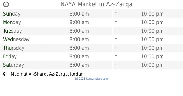
NAYA Market
Az-Zarqa
Grocery or supermarket
read more
4.199 km
Abu Amjad Algoere Grocery
خلف انس مول
Grocery or supermarket
read more
4.21 km
Izzidien Supermarket And Coffee
25
Grocery or supermarket
read more
4.515 km
Mix Market
Az-Zarqa
Grocery or supermarket
read more
4.588 km
3-days Market
Az-Zarqa
Grocery or supermarket
read more
4.623 km
سوبرماركت زمزم
Az-Zarqa
Grocery or supermarket
read more
4.624 km
Zain Supermarket
Az-Zarqa
Grocery or supermarket
read more
4.704 km
Jerusalem Grocery
Az-Zarqa
Grocery or supermarket
read more
4.722 km
Yahya Mall for Fruits and Vegetables
Army Street, Az-Zarqa
Grocery or supermarket
read more
5.006 km
Grocery Palm Village
Az-Zarqa
Grocery or supermarket
read more
5.102 km
حياة مول
Az-Zarqa
Grocery or supermarket
read more
5.134 km
Super Market Almhoude
Az-Zarqa
Grocery or supermarket
read more
5.177 km
اسواق المختار
Az-Zarqa
Grocery or supermarket
read more
5.442 km
Alnaim Grocery
Az-Zarqa
Grocery or supermarket
read more
5.446 km
Alloush Market
Az-Zarqa
Grocery or supermarket
read more
5.456 km
Mini Mall
Az-Zarqa
Grocery or supermarket
read more
📑
all categories
Accounting
Administrative area level 1
Administrative area level 2
Airport
Amusement park
Aquarium
Art gallery
Atm
Bakery
Bank
Bar
Beauty salon
Bicycle store
Book store
Bowling alley
Bus station
Cafe
Campground
Car dealer
Car rental
Car repair
Car wash
Cemetery
Church
City hall
Clothing store
Colloquial area
Convenience store
Country
Courthouse
Dentist
Department store
Doctor
Electrician
Electronics store
Embassy
Finance
Fire station
Florist
Food
Funeral home
Furniture store
Gas station
General contractor
Grocery or supermarket
Gym
Hair care
Hardware store
Health
Home goods store
Hospital
Insurance agency
Jewelry store
Laundry
Lawyer
Library
Liquor store
Local government office
Locality
Locksmith
Lodging
Meal delivery
Meal takeaway
Mosque
Movie rental
Movie theater
Moving company
Museum
Natural feature
Neighborhood
Night club
Painter
Park
Parking
Pet store
Pharmacy
Physiotherapist
Place of worship
Plumber
Point of interest
Police
Post office
Premise
Real estate agency
Restaurant
Route
Rv park, camping
School
Shoe store
Shopping mall
Spa
Stadium
Storage
Store
Supermarket
Taxi stand
Train station
Travel agency
University
Veterinary care
Zoo
sublocality level 1
↑