Cafe nearby Victory Cafe
Jordan
Cafe nearby Victory Cafe
Victory Cafe
Al bayader/ Jamal kaytouka St., Amman, ירדן
contacts phone
:
+962
Latitude:
31.952389
, Longitude:
35.8406052
larger map & directions
read more
nearest Cafe
197 m
Talet Al Bayader Coffee Shop
Amman
Cafe
read more
230 m
Mustache coffee - قهوة عالشوارب
Jamal Qaytouqah Street, Amman
Cafe
read more
327 m
Abu Zaid Cafeteria
Complex No 29, Husni Soubar St 29, Amman
Cafe
read more
736 m
Coffee Ghalayeeni
Ahmad Oklah An-Nassour Street, Amman
Cafe
read more
843 m
بن المهند
Al Jandawil, Amman
Cafe
read more
843 m
بن المهند
Amman
Cafe
read more
860 m
قهوة العنق
As-Senaah Street, Amman
Cafe
read more
942 m
La Vida cake
Amman
Cafe
read more
982 m
قهوة العم لهلوب
ش. الصناعة،, Amman
Cafe
read more
1.258 km
Al-Mulahen
Amman
Cafe
read more
1.265 km
Wade3 Zamman Restaurant & Cafe مقهى وديع زمان
Princess Sumayah Bent Al-Hasan Street, Amman
Cafe
read more
1.274 km
Sabir And Radi Cafeteria
Amman
Cafe
read more
1.278 km
اهوة كوتشينا
Abd Ar-Rahman Khalifah St, Amman
Cafe
read more
1.369 km
مطعم و كافيه صهلله
Unnamed Road, Amman
Cafe
read more
1.43 km
The Coffee Bean & Tea Leaf 5
Massoud Ben Saed Street, Amman
Cafe
read more
1.593 km
MON CHOU Frensh Pastries
30, 22, Saleh As-Samadi Street, Amman
Cafe
read more
1.611 km
Raqmu Coffee House
Yazid Al-Asadi Street, Amman
Cafe
read more
1.638 km
توصيل اراجيل
Princess Tharwat Al-Hasan Street, Amman
Cafe
read more
1.701 km
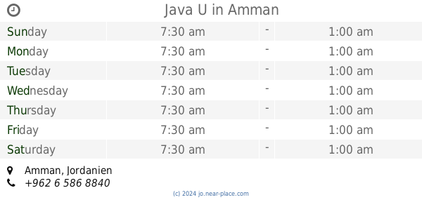
Java U
Amman
Cafe
read more
1.805 km
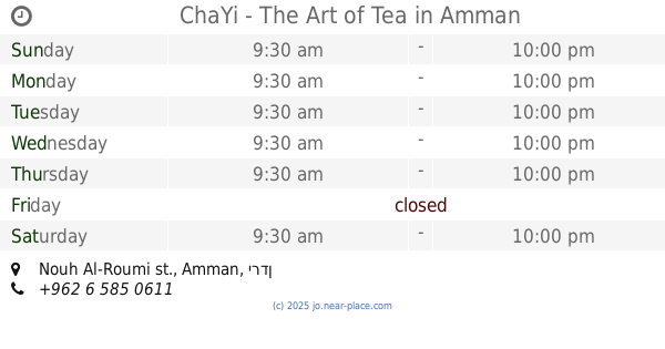
ChaYi - The Art of Tea
Nouh Al-Roumi st.
Cafe
read more
1.835 km
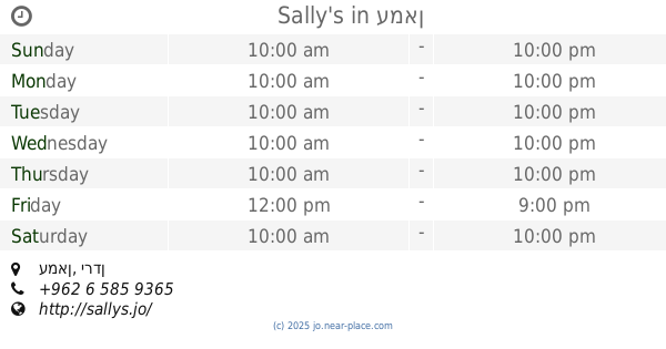
Sally's
Amman
Cafe
read more
1.839 km
مقهى چاي خانة
Paris Street 17, Amman
Cafe
read more
1.952 km
Nas w Nas
Wakalat, Amman
Cafe
read more
1.957 km
Helium هيليوم
Amman
Cafe
read more
2.284 km
Ahwet Abdeen أهوة عابدين
Abdallah Ghosheh Street, Amman
Cafe
read more
📑
all categories
Accounting
Administrative area level 1
Administrative area level 2
Airport
Amusement park
Aquarium
Art gallery
Atm
Bakery
Bank
Bar
Beauty salon
Bicycle store
Book store
Bowling alley
Bus station
Cafe
Campground
Car dealer
Car rental
Car repair
Car wash
Cemetery
Church
City hall
Clothing store
Colloquial area
Convenience store
Country
Courthouse
Dentist
Department store
Doctor
Electrician
Electronics store
Embassy
Finance
Fire station
Florist
Food
Funeral home
Furniture store
Gas station
General contractor
Grocery or supermarket
Gym
Hair care
Hardware store
Health
Home goods store
Hospital
Insurance agency
Jewelry store
Laundry
Lawyer
Library
Liquor store
Local government office
Locality
Locksmith
Lodging
Meal delivery
Meal takeaway
Mosque
Movie rental
Movie theater
Moving company
Museum
Natural feature
Neighborhood
Night club
Painter
Park
Parking
Pet store
Pharmacy
Physiotherapist
Place of worship
Plumber
Point of interest
Police
Post office
Premise
Real estate agency
Restaurant
Route
Rv park, camping
School
Shoe store
Shopping mall
Spa
Stadium
Storage
Store
Supermarket
Taxi stand
Train station
Travel agency
University
Veterinary care
Zoo
sublocality level 1
↑