Cafe nearby توصيل اراجيل
Jordan
Cafe nearby توصيل اراجيل
توصيل اراجيل
Princess Tharwat Al-Hasan Street, Amman ישראל
contacts phone
:
+962
Latitude:
31.966715
, Longitude:
35.844659
read more
nearest Cafe
17 m
Costa Coffee - prince Rashid
Amman
Cafe
read more
509 m
Media Cafe
Naser Al Daoud Commercial Complex, Princess Tharwat Al Hasan St 126,
Cafe
read more
727 m
La Vida cake
Amman
Cafe
read more
772 m
Stickhouse Jordan
Al Rawabi, Amman
Cafe
read more
774 m
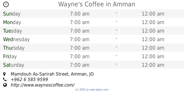
Wayne's Coffee
Mamdouh As-Sarirah Street, Amman
Cafe
read more
803 m
The Squad
Mamdouh As-Sarirah Street, Amman
Cafe
read more
816 m
The Squad
Mamdouh Al-Sarayrah Street, Street
Cafe
read more
840 m
Dimitri's Coffee
Mamdouh al Sarayra St، عمّان
Cafe
read more
877 m
Olibol Donuts
Mamdouh Al-Sarayrah Street, Amman
Cafe
read more
877 m
Olibol Donuts
Mamdouh As-Sarirah Street, Amman
Cafe
read more
880 m
Ahwitna Cafe
Amman
Cafe
read more
883 m
Raqmu Coffee House
Yazid Al-Asadi Street, Amman
Cafe
read more
883 m
Classic Rock Coffee Company
Mamdouh As-Sarirah Street, Amman
Cafe
read more
888 m
اهوة شيخ الجبل
Mecca Street 263, Amman
Cafe
read more
899 m
مقهى الباشا
Mamdouh As-Sarirah Street, Amman
Cafe
read more
904 m
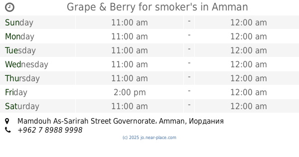
Grape & Berry for smoker's
Mamdouh As-Sarirah Street Governorate, Amman
Cafe
read more
1.004 km
Ahwet Abdeen أهوة عابدين
Abdallah Ghosheh Street, Amman
Cafe
read more
1.034 km
اهوة كوتشينا
Abd Ar-Rahman Khalifah St, Amman
Cafe
read more
1.036 km
AlFalamanki
Amman
Cafe
read more
1.196 km
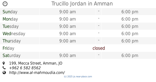
Trucillo Jordan
Mecca Street 199, Amman
Cafe
read more
1.202 km
Rewayat Cafe
Jaber complex, Mecca street, Amman
Cafe
read more
1.214 km
Karakeeb Cafe
Amman
Cafe
read more
1.252 km
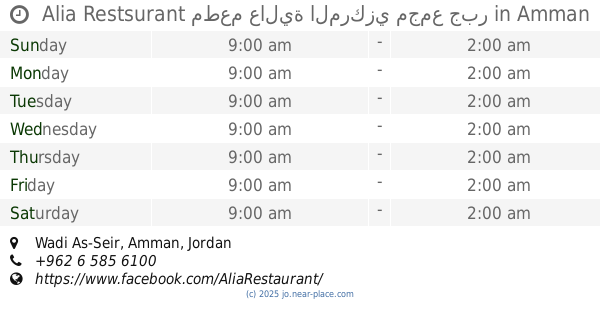
Alia Restsurant مطعم عالية المركزي مجمع جبر
Amman
Cafe
read more
1.265 km
صالون العراب
Unnamed, Al Hezam Road, Amman
Cafe
read more
1.265 km
Godfather Saloon
Unnamed, Al Hezam Road, Amman
Cafe
read more
📑
all categories
Accounting
Administrative area level 1
Administrative area level 2
Airport
Amusement park
Aquarium
Art gallery
Atm
Bakery
Bank
Bar
Beauty salon
Bicycle store
Book store
Bowling alley
Bus station
Cafe
Campground
Car dealer
Car rental
Car repair
Car wash
Cemetery
Church
City hall
Clothing store
Colloquial area
Convenience store
Country
Courthouse
Dentist
Department store
Doctor
Electrician
Electronics store
Embassy
Finance
Fire station
Florist
Food
Funeral home
Furniture store
Gas station
General contractor
Grocery or supermarket
Gym
Hair care
Hardware store
Health
Home goods store
Hospital
Insurance agency
Jewelry store
Laundry
Lawyer
Library
Liquor store
Local government office
Locality
Locksmith
Lodging
Meal delivery
Meal takeaway
Mosque
Movie rental
Movie theater
Moving company
Museum
Natural feature
Neighborhood
Night club
Painter
Park
Parking
Pet store
Pharmacy
Physiotherapist
Place of worship
Plumber
Point of interest
Police
Post office
Premise
Real estate agency
Restaurant
Route
Rv park, camping
School
Shoe store
Shopping mall
Spa
Stadium
Storage
Store
Supermarket
Taxi stand
Train station
Travel agency
University
Veterinary care
Zoo
sublocality level 1
↑