School nearby School Zaatari Comprehensive Secondary Boys
Jordan
School nearby School Zaatari Comprehensive Secondary Boys
School Zaatari Comprehensive Secondary Boys
Эль-Мафрак, Иордания
contacts phone
:
+962 7 7215 9645
Latitude:
32.3131509
, Longitude:
36.3032866
larger map & directions
read more
nearest School
79 m
Zaatari Elementary School
School
read more
654 m
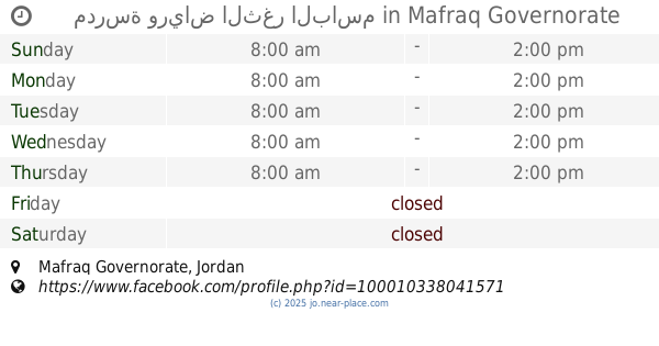
مدرسة ورياض الثغر الباسم
School
read more
739 m
Rabieh High School
School
read more
797 m
مدرسه اسماء بنت ابي بكر
School
read more
854 m
Safia Abdul Muttalib School girl
School
read more
2.352 km
المدرسة البحرينية
School
read more
3.612 km
مركز الشباب NRC
School
read more
4.15 km
IRD D7 community center
School
read more
4.198 km
Solar 1
School
read more
5.95 km
مدرسة ام الجمال للبنين
School
read more
6.652 km
الابرار النموذجية الاساسية المختلطة
Al-Mafraq
School
read more
6.755 km
مدرسة الابرار الاساسية للبنات
Al-Mafraq
School
read more
6.995 km
Albaj Secondary School For Girls
School
read more
7.196 km
مدرسة الباعج الاساسية للبنين
Al-Ba'ij
School
read more
8.043 km
عمر بن الخطاب س ذكور
Unnamed Road, Umm el-Jimal
School
read more
9.009 km
مدرسة المفرق الاساسية الثانية
Al-Mafraq
School
read more
9.019 km
Makani Center Save The Children Jordan
Al-Mafraq
School
read more
9.411 km
مدرسة المشرف الاساسية بنات
Al-Ba'ij
School
read more
9.557 km
Fawzi al-Mulki Secondary Boys
Al-Mafraq
School
read more
9.675 km
Greek Catholic Kindergarten Al-Mafraq, روضة الروم الكاثوليك المفرق
Al, Al-Mafraq
School
read more
10.138 km
مدرسة النهج الانسانيHuman Concern School
Al-Mafraq
School
read more
10.149 km
مدرسة ابو عبيدة عامر بن الجراح
Al-Mafraq
School
read more
10.153 km
مدرسة انساني الاساسية
Al, Al-Mafraq
School
read more
14.278 km
Fatima Zahra Secondary School for Girls
School
read more
19.496 km
A fourth school Altip basic
School
read more
📑
all categories
Accounting
Administrative area level 1
Administrative area level 2
Airport
Amusement park
Aquarium
Art gallery
Atm
Bakery
Bank
Bar
Beauty salon
Bicycle store
Book store
Bowling alley
Bus station
Cafe
Campground
Car dealer
Car rental
Car repair
Car wash
Cemetery
Church
City hall
Clothing store
Colloquial area
Convenience store
Country
Courthouse
Dentist
Department store
Doctor
Electrician
Electronics store
Embassy
Finance
Fire station
Florist
Food
Funeral home
Furniture store
Gas station
General contractor
Grocery or supermarket
Gym
Hair care
Hardware store
Health
Home goods store
Hospital
Insurance agency
Jewelry store
Laundry
Lawyer
Library
Liquor store
Local government office
Locality
Locksmith
Lodging
Meal delivery
Meal takeaway
Mosque
Movie rental
Movie theater
Moving company
Museum
Natural feature
Neighborhood
Night club
Painter
Park
Parking
Pet store
Pharmacy
Physiotherapist
Place of worship
Plumber
Point of interest
Police
Post office
Premise
Real estate agency
Restaurant
Route
Rv park, camping
School
Shoe store
Shopping mall
Spa
Stadium
Storage
Store
Supermarket
Taxi stand
Train station
Travel agency
University
Veterinary care
Zoo
sublocality level 1
↑