School nearby مدرسة المشرف الاساسية بنات
Jordan
School nearby مدرسة المشرف الاساسية بنات
مدرسة المشرف الاساسية بنات
Al-Ba'ij, Jordania
contacts phone
:
+962
Latitude:
32.3883633
, Longitude:
36.3492458
larger map & directions
read more
nearest School
2.216 km
مدرسة الباعج الاساسية للبنين
Al-Ba'ij
School
read more
2.216 km
مدرسة الباعج الثانوية للبنين
Al-Ba'ij
School
read more
2.463 km
Albaj Secondary School For Girls
School
read more
5.098 km
مدرسة نسيبة المازنية الاساسية المختلطة
School
read more
5.794 km
الكوم الاحمر الثانوية الشاملة للبنين
School
read more
5.896 km
School or Secondary Squadron Boys
School
read more
6.652 km
School or Secondary Comprehensive Beauty Mixed (Girls)
School
read more
7.08 km
مدرسة ام الجمال للبنين
School
read more
11.147 km
عمر بن الخطاب س ذكور
Unnamed Road, Umm el-Jimal
School
read more
12.052 km
الابرار النموذجية الاساسية المختلطة
Al-Mafraq
School
read more
12.065 km
مدرسة الابرار الاساسية للبنات
Al-Mafraq
School
read more
12.507 km
Эмердженси Полис Трейнинг Скул
Al-Mafraq
School
read more
13.429 km
مدرسة النهج الانسانيHuman Concern School
Al-Mafraq
School
read more
13.436 km
مدرسة انساني الاساسية
Al, Al-Mafraq
School
read more
13.748 km
مدرسة ابو عبيدة عامر بن الجراح
Al-Mafraq
School
read more
13.864 km
مدرسة المفرق الاساسية الثانية
Al-Mafraq
School
read more
13.949 km
Fawzi al-Mulki Secondary Boys
Al-Mafraq
School
read more
14.016 km
مدرسة الحافظين الخاصة
Al-Mafraq
School
read more
14.388 km
Greek Catholic Kindergarten Al-Mafraq, روضة الروم الكاثوليك المفرق
Al, Al-Mafraq
School
read more
14.77 km
Forqan Quran Center
Hamza Bin Abd-Almuttalib, Al-Mafraq
School
read more
14.771 km
Makani Center Save The Children Jordan
Al-Mafraq
School
read more
15.576 km
Mixed flowers basic school district
Al-Mafraq
School
read more
15.685 km
School Sabha Secondary Comprehensive Girls
School
read more
19.014 km
Salehia High School Mixed
School
read more
20.374 km
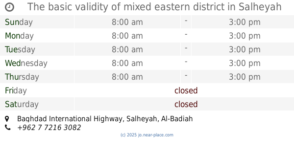
The basic validity of mixed eastern district
Baghdad International Highway, Salheyah
School
read more
📑
all categories
Accounting
Administrative area level 1
Administrative area level 2
Airport
Amusement park
Aquarium
Art gallery
Atm
Bakery
Bank
Bar
Beauty salon
Bicycle store
Book store
Bowling alley
Bus station
Cafe
Campground
Car dealer
Car rental
Car repair
Car wash
Cemetery
Church
City hall
Clothing store
Colloquial area
Convenience store
Country
Courthouse
Dentist
Department store
Doctor
Electrician
Electronics store
Embassy
Finance
Fire station
Florist
Food
Funeral home
Furniture store
Gas station
General contractor
Grocery or supermarket
Gym
Hair care
Hardware store
Health
Home goods store
Hospital
Insurance agency
Jewelry store
Laundry
Lawyer
Library
Liquor store
Local government office
Locality
Locksmith
Lodging
Meal delivery
Meal takeaway
Mosque
Movie rental
Movie theater
Moving company
Museum
Natural feature
Neighborhood
Night club
Painter
Park
Parking
Pet store
Pharmacy
Physiotherapist
Place of worship
Plumber
Point of interest
Police
Post office
Premise
Real estate agency
Restaurant
Route
Rv park, camping
School
Shoe store
Shopping mall
Spa
Stadium
Storage
Store
Supermarket
Taxi stand
Train station
Travel agency
University
Veterinary care
Zoo
sublocality level 1
↑