School nearby Blue Branch Business Development Center
Jordan
School nearby Blue Branch Business Development Center
Blue Branch Business Development Center
Army Street, Az-Zarqa, Zarqa Qasabah District, JO Иордания
contacts phone
:
+962 5 393 3023
website:
www.bdc.org.jo
Latitude:
32.0495169
, Longitude:
36.0988792
larger map & directions
read more
nearest School
536 m
مدارس انوارالاندلس الزرقاء
Az-Zarqa
School
read more
579 m
مدرسة ام كلثوم الثانوية للبنات
Az-Zarqa
School
read more
579 m
Um Kulthoum School
Az-Zarqa
School
read more
592 m
Jabal Tareq School | مدرسة جبل طارق للذكور
Az-Zarqa
School
read more
625 m
Gibraltar American School
Az-Zarqa
School
read more
732 m
مدرسة رفيدة الاسلمية الاساسية للبنات
Az-Zarqa
School
read more
746 m
Rufaida al-aslamia School for Girls
Az-Zarqa
School
read more
845 m
Jnaah School
Az-Zarqa
School
read more
891 m
UNRWA school UNICEF
Az-Zarqa
School
read more
898 m
Ramleh School
Az-Zarqa
School
read more
910 m
Zarqa Prep Boys School 2 - UNRWA
Az-Zarqa
School
read more
913 m
Tariq bin Ziyad School
Az-Zarqa
School
read more
914 m
مدرسة رملة بنت ابي سفيان
Az-Zarqa
School
read more
915 m
مدرسة رمله بنت ابي سفيان الاساسية للبنات
Az-Zarqa
School
read more
965 m
Zarqa Prep Boys School 1 - UNRWA
Az-Zarqa
School
read more
1.013 km
مدارس ورياض الجندول الحديثه
الثوره العربية الكبرى،، الزرقاء
School
read more
1.013 km
مدارس ورياض الجندول الحديثه
Az-Zarqa
School
read more
1.033 km
Zarqa Prep Girls School 2 - UNRWA
Az-Zarqa
School
read more
1.06 km
مدرسة الجندول
Army Street, Az-Zarqa
School
read more
1.062 km
UNRWA schools group, the blue camp
Az-Zarqa
School
read more
1.172 km
مدارس السلطان محمد الفاتح
Az-Zarqa
School
read more
1.335 km
مدرسة خادم الحرمين
الزرقاء الشرق شارع مدرسة، خادم الحرمين، الشريفين،
School
read more
1.435 km
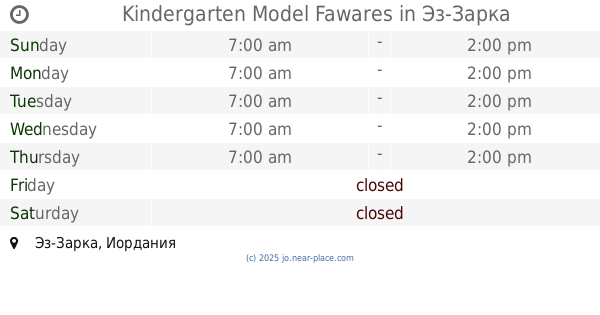
Kindergarten Model Fawares
Az-Zarqa
School
read more
2.06 km
Al-Muhallab ibn Abi Sufra middle school
King Fisal, Az-Zarqa
School
read more
2.167 km
مدرسة عكا الابتدائية
Az-Zarqa
School
read more
📑
all categories
Accounting
Administrative area level 1
Administrative area level 2
Airport
Amusement park
Aquarium
Art gallery
Atm
Bakery
Bank
Bar
Beauty salon
Bicycle store
Book store
Bowling alley
Bus station
Cafe
Campground
Car dealer
Car rental
Car repair
Car wash
Cemetery
Church
City hall
Clothing store
Colloquial area
Convenience store
Country
Courthouse
Dentist
Department store
Doctor
Electrician
Electronics store
Embassy
Finance
Fire station
Florist
Food
Funeral home
Furniture store
Gas station
General contractor
Grocery or supermarket
Gym
Hair care
Hardware store
Health
Home goods store
Hospital
Insurance agency
Jewelry store
Laundry
Lawyer
Library
Liquor store
Local government office
Locality
Locksmith
Lodging
Meal delivery
Meal takeaway
Mosque
Movie rental
Movie theater
Moving company
Museum
Natural feature
Neighborhood
Night club
Painter
Park
Parking
Pet store
Pharmacy
Physiotherapist
Place of worship
Plumber
Point of interest
Police
Post office
Premise
Real estate agency
Restaurant
Route
Rv park, camping
School
Shoe store
Shopping mall
Spa
Stadium
Storage
Store
Supermarket
Taxi stand
Train station
Travel agency
University
Veterinary care
Zoo
sublocality level 1
↑