School nearby مدارس ورياض الجندول الحديثه
Jordan
School nearby مدارس ورياض الجندول الحديثه
مدارس ورياض الجندول الحديثه
الثوره العربية الكبرى،، الزرقاء، Иордания
contacts phone
:
+962 5 365 7088
Latitude:
32.0430499
, Longitude:
36.0913133
larger map & directions
read more
nearest School
349 m
Hend bnt Omaiah school
Az-Zarqa
School
read more
365 m
Islamic Union for Girls Schools
Az-Zarqa
School
read more
473 m
مدرسة ام كلثوم الثانوية للبنات
Az-Zarqa
School
read more
486 m
Gibraltar American School
Az-Zarqa
School
read more
515 m
مدرسة الامام البخاري
Az-Zarqa
School
read more
515 m
Umm Darda School
Az-Zarqa
School
read more
535 m
Jabal Tareq School | مدرسة جبل طارق للذكور
Az-Zarqa
School
read more
540 m
مدرسة الاتحاد الاسلامية للبنين
Az-Zarqa
School
read more
592 m
مدارس اكاديمية الالهام الدولية
Az-Zarqa
School
read more
608 m
مدرسة رمله بنت ابي سفيان الاساسية للبنات
Az-Zarqa
School
read more
636 m
مدرسة رملة بنت ابي سفيان
Az-Zarqa
School
read more
670 m
Jnaah School
Az-Zarqa
School
read more
693 m
Tariq bin Ziyad School
Az-Zarqa
School
read more
697 m
Schools and kindergarten Bhaedin Islamic
Az-Zarqa
School
read more
698 m
مدرسة معاوية بن ابي سفيان الثانوية للبنين
Az-Zarqa
School
read more
727 m
مدرسة الفاروق الاسلامية
Az-Zarqa
School
read more
800 m
School Umm al-Darda secondary
Az-Zarqa
School
read more
809 m
مدرسة أحد الإسلامية الخاصة
Az-Zarqa
School
read more
853 m
مدرسة الاميرة رحمة الاساسية
Wadi Al-Kharoub Street, Amman
School
read more
859 m
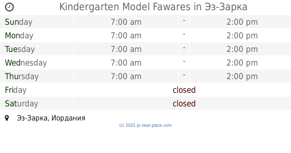
Kindergarten Model Fawares
Az-Zarqa
School
read more
1.033 km
Housing Marka School
Amman
School
read more
1.055 km
مدرسة الزرقاء الحديثة
Az-Zarqa
School
read more
1.058 km
Kindergarten Academy Planet Creativity
الابرار
School
read more
1.069 km
مدرسة الجاحظ الثانوية
Az-Zarqa
School
read more
1.075 km
Al Jaheth school
Az-Zarqa
School
read more
📑
all categories
Accounting
Administrative area level 1
Administrative area level 2
Airport
Amusement park
Aquarium
Art gallery
Atm
Bakery
Bank
Bar
Beauty salon
Bicycle store
Book store
Bowling alley
Bus station
Cafe
Campground
Car dealer
Car rental
Car repair
Car wash
Cemetery
Church
City hall
Clothing store
Colloquial area
Convenience store
Country
Courthouse
Dentist
Department store
Doctor
Electrician
Electronics store
Embassy
Finance
Fire station
Florist
Food
Funeral home
Furniture store
Gas station
General contractor
Grocery or supermarket
Gym
Hair care
Hardware store
Health
Home goods store
Hospital
Insurance agency
Jewelry store
Laundry
Lawyer
Library
Liquor store
Local government office
Locality
Locksmith
Lodging
Meal delivery
Meal takeaway
Mosque
Movie rental
Movie theater
Moving company
Museum
Natural feature
Neighborhood
Night club
Painter
Park
Parking
Pet store
Pharmacy
Physiotherapist
Place of worship
Plumber
Point of interest
Police
Post office
Premise
Real estate agency
Restaurant
Route
Rv park, camping
School
Shoe store
Shopping mall
Spa
Stadium
Storage
Store
Supermarket
Taxi stand
Train station
Travel agency
University
Veterinary care
Zoo
sublocality level 1
↑