Restaurant nearby Altaybeh Resturant
Coronavirus disease (COVID-19) Situation
confirmed cases
1746997
deaths
14122
Jordan
Restaurant nearby Altaybeh Resturant
Altaybeh Resturant
אירביד, ירדן
contacts phone
:
+962
Latitude:
32.5432591
, Longitude:
35.7191904
larger map & directions
read more
nearest Restaurant
322 m
Tatli Resturant
Restaurant
read more
3.308 km
Abu Imad Restaurant
Qumaym
Restaurant
read more
3.435 km
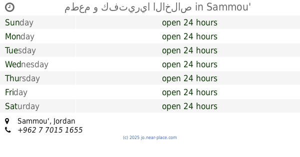
مطعم و كفتيريا الاخلاص
Sammou'
Restaurant
read more
3.52 km
Al Anwar Restaurant
Restaurant
read more
3.724 km
Falafil Taqli فلافل الطقلي
Qumaym
Restaurant
read more
4.316 km
مطاعم الأكل الطيب - صما
Restaurant
read more
5.732 km
كيفيا كافيه Kifia Kafee
Restaurant
read more
5.917 km
Dolma Restaurant & Cafe
Deir Abu Said
Restaurant
read more
11.047 km
Restaurant & Grills Kababjee
Irbid
Restaurant
read more
11.838 km
مطعم حارتنا
Irbid
Restaurant
read more
12.406 km
مطعم واصف
King Talal Street, Irbid
Restaurant
read more
12.478 km
Oasis Pastry
Irbid
Restaurant
read more
12.509 km
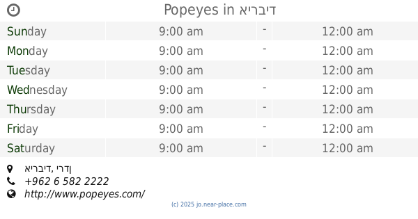
Popeyes
Irbid
Restaurant
read more
12.632 km
Shaikh Al Shawarma
Irbid
Restaurant
read more
12.657 km
مطعم قوزال التركي
Irbid
Restaurant
read more
12.932 km
Restaurants Shakereen
اربد-شارع الجامعه-مقابل النادى العربى, Irbid
Restaurant
read more
13.286 km
Hungry Snack
Unnamed Road, Irbid
Restaurant
read more
13.527 km
حلويات باشي
إربد،
Restaurant
read more
13.678 km
Chimney House
لواء بني عبيد،
Restaurant
read more
13.777 km
Lemon
Бейт-Шеан
Restaurant
read more
13.78 km
Ocean Fresh
Irbid
Restaurant
read more
14.014 km
Grill Mark
makka almukrmah street, Irbid
Restaurant
read more
14.571 km
مطعم كثرات الخير
Irbid
Restaurant
read more
14.632 km
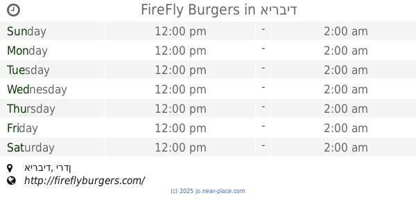
FireFly Burgers
Irbid
Restaurant
read more
14.974 km
مطاعم امية
Wasfi At-Tal Street
Restaurant
read more
📑
all categories
Accounting
Administrative area level 1
Administrative area level 2
Airport
Amusement park
Aquarium
Art gallery
Atm
Bakery
Bank
Bar
Beauty salon
Bicycle store
Book store
Bowling alley
Bus station
Cafe
Campground
Car dealer
Car rental
Car repair
Car wash
Cemetery
Church
City hall
Clothing store
Colloquial area
Convenience store
Country
Courthouse
Dentist
Department store
Doctor
Electrician
Electronics store
Embassy
Finance
Fire station
Florist
Food
Funeral home
Furniture store
Gas station
General contractor
Grocery or supermarket
Gym
Hair care
Hardware store
Health
Home goods store
Hospital
Insurance agency
Jewelry store
Laundry
Lawyer
Library
Liquor store
Local government office
Locality
Locksmith
Lodging
Meal delivery
Meal takeaway
Mosque
Movie rental
Movie theater
Moving company
Museum
Natural feature
Neighborhood
Night club
Painter
Park
Parking
Pet store
Pharmacy
Physiotherapist
Place of worship
Plumber
Point of interest
Police
Post office
Premise
Real estate agency
Restaurant
Route
Rv park, camping
School
Shoe store
Shopping mall
Spa
Stadium
Storage
Store
Supermarket
Taxi stand
Train station
Travel agency
University
Veterinary care
Zoo
sublocality level 1
↑