Restaurant nearby مطعم حارتنا
Coronavirus disease (COVID-19) Situation
confirmed cases
1746997
deaths
14122
Jordan
Restaurant nearby مطعم حارتنا
مطعم حارتنا
אירביד, ירדן
contacts phone
:
+962
Latitude:
32.5626394
, Longitude:
35.8433971
larger map & directions
read more
nearest Restaurant
433 m
مطعم وشاورما البارحة
Irbid
Restaurant
read more
760 m
FireFly Burgers
Al Thaqafeh Street, Irbid
Restaurant
read more
760 m
مطعم بيتزا ترويئة بيروت
اربد قرب دوار، ابو اشرف،
Restaurant
read more
760 m
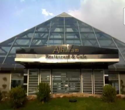
Pyramid Restaurant
Irbid
Restaurant
read more
763 m
مطعم زمان الخير
Irbid
Restaurant
read more
816 m
مطعم طلفاح
Al-Hashmi Street, Irbid
Restaurant
read more
822 m
Oasis Pastry
Irbid
Restaurant
read more
849 m
مطعم طيبة ضيعتنا
ش. أمين آغا،، إربد
Restaurant
read more
913 m
مطعم ومشاوي الاقصى
شارع الملك طلال،, Irbid
Restaurant
read more
915 m
مطعم قاسميه الفوال
شارع الملك طلال، إربد،
Restaurant
read more
931 m
مطعم البرنس
Al Hashmi, Irbid
Restaurant
read more
945 m
مطعم قاسمية
Irbid
Restaurant
read more
949 m
معجنات الباشا
Irbid
Restaurant
read more
974 m
شاورما النغش
10, Irbid
Restaurant
read more
987 m
مطعم واصف
King Talal Street, Irbid
Restaurant
read more
1.009 km
حلويات وبوظة السيران
Irbid
Restaurant
read more
1.02 km
Rawas Abu Awwad Restaurant
Wasi At-Tal Square, Irbid
Restaurant
read more
1.104 km
Restaurant & Grills Kababjee
Irbid
Restaurant
read more
1.131 km
Break the journey
Irbid
Restaurant
read more
1.153 km
مطعم المقبل
Irbid
Restaurant
read more
1.172 km
مطعم لقمه هنيه١
حي المنارة،, Irbid
Restaurant
read more
1.178 km
Bismellah Snackسناكات بسم الله
Irbid
Restaurant
read more
1.285 km
مطعم فلسطين Restuarant Palestine
Irbid
Restaurant
read more
1.349 km
مطعم قوزال التركي
Irbid
Restaurant
read more
1.358 km
مطعم لحم وفحم
Irbid
Restaurant
read more
📑
all categories
Accounting
Administrative area level 1
Administrative area level 2
Airport
Amusement park
Aquarium
Art gallery
Atm
Bakery
Bank
Bar
Beauty salon
Bicycle store
Book store
Bowling alley
Bus station
Cafe
Campground
Car dealer
Car rental
Car repair
Car wash
Cemetery
Church
City hall
Clothing store
Colloquial area
Convenience store
Country
Courthouse
Dentist
Department store
Doctor
Electrician
Electronics store
Embassy
Finance
Fire station
Florist
Food
Funeral home
Furniture store
Gas station
General contractor
Grocery or supermarket
Gym
Hair care
Hardware store
Health
Home goods store
Hospital
Insurance agency
Jewelry store
Laundry
Lawyer
Library
Liquor store
Local government office
Locality
Locksmith
Lodging
Meal delivery
Meal takeaway
Mosque
Movie rental
Movie theater
Moving company
Museum
Natural feature
Neighborhood
Night club
Painter
Park
Parking
Pet store
Pharmacy
Physiotherapist
Place of worship
Plumber
Point of interest
Police
Post office
Premise
Real estate agency
Restaurant
Route
Rv park, camping
School
Shoe store
Shopping mall
Spa
Stadium
Storage
Store
Supermarket
Taxi stand
Train station
Travel agency
University
Veterinary care
Zoo
sublocality level 1
↑