Supermarket nearby محمص تاج الدين
Jordan
Supermarket nearby محمص تاج الدين
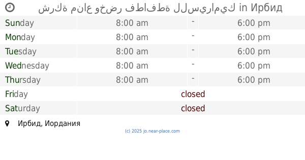
محمص تاج الدين
بيت راس - الشارع الرئيسي - قبل جسر المشاة ب، ١٠٠ متر،، Иордания
contacts phone
:
+962 7 7221 8054
website:
www.facebook.com
Latitude:
32.5989141
, Longitude:
35.8625162
larger map & directions
read more
nearest Supermarket
1.536 km
Tariq consumer markets
35
Supermarket
read more
2.119 km
سلسلة اسواق مكة
Hakama Street, Irbid
Supermarket
read more
2.201 km
Super Maher Supermarket
Irbid
Supermarket
read more
2.42 km
هايبر ماركت الرزانا
شارع القدس،، إربد
Supermarket
read more
3.022 km
وكالة المجدل لقطع سيارات نيسان
Industrial City Circle, Irbid
Supermarket
read more
3.483 km
شركة مناع وخضر فطافطة للسيراميك
Irbid
Supermarket
read more
3.572 km
سوبر ماركت بن الطائي
Irbid
Supermarket
read more
3.84 km
محلات كامل عبابنه
Irbid
Supermarket
read more
3.862 km
نبيل شتاتسوبر ماركت ابو
El Nasr Street, Irbid
Supermarket
read more
4 km
Super Market Abu Hija
Abdul Qader Al-Husseini Street, Irbid
Supermarket
read more
4.067 km
Gassan Supermarket
Irbid
Supermarket
read more
4.324 km
محل ابو طارق السرحان للالعاب
Queen Nour Street, Irbid
Supermarket
read more
4.437 km
سوبرماركت أبو عكّاز
Queen Nour Street, Irbid
Supermarket
read more
4.69 km
Zamzam Global markets Hashemi Street
Irbid
Supermarket
read more
4.725 km
بطاقات جملة وسيم المستريحي
حي الاندلس،, Irbid
Supermarket
read more
4.736 km
معرض و مصنع الكوفحي
Irbid
Supermarket
read more
4.743 km
أسواق الرشدان الاستهلاكية
Irbid
Supermarket
read more
4.829 km
Sami Abu Tariq Supermarket
Supermarket
read more
4.832 km
Library Abrar Stationery, books and decor
Wasfi At-Tall Street, Irbid
Supermarket
read more
4.861 km
سوبر ماركت انمار
Jordan
Supermarket
read more
4.865 km
El Abed Supermarket
Amman Street, Irbid
Supermarket
read more
4.971 km
MK Water
Irbid
Supermarket
read more
4.973 km
سوبر ماركت عقيل شطناري
Irbid
Supermarket
read more
5.025 km
Bilal stationary
Irbid
Supermarket
read more
5.475 km
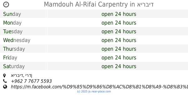
Mamdouh Al-Rifai Carpentry
אירביד
Supermarket
read more
📑
all categories
Accounting
Administrative area level 1
Administrative area level 2
Airport
Amusement park
Aquarium
Art gallery
Atm
Bakery
Bank
Bar
Beauty salon
Bicycle store
Book store
Bowling alley
Bus station
Cafe
Campground
Car dealer
Car rental
Car repair
Car wash
Cemetery
Church
City hall
Clothing store
Colloquial area
Convenience store
Country
Courthouse
Dentist
Department store
Doctor
Electrician
Electronics store
Embassy
Finance
Fire station
Florist
Food
Funeral home
Furniture store
Gas station
General contractor
Grocery or supermarket
Gym
Hair care
Hardware store
Health
Home goods store
Hospital
Insurance agency
Jewelry store
Laundry
Lawyer
Library
Liquor store
Local government office
Locality
Locksmith
Lodging
Meal delivery
Meal takeaway
Mosque
Movie rental
Movie theater
Moving company
Museum
Natural feature
Neighborhood
Night club
Painter
Park
Parking
Pet store
Pharmacy
Physiotherapist
Place of worship
Plumber
Point of interest
Police
Post office
Premise
Real estate agency
Restaurant
Route
Rv park, camping
School
Shoe store
Shopping mall
Spa
Stadium
Storage
Store
Supermarket
Taxi stand
Train station
Travel agency
University
Veterinary care
Zoo
sublocality level 1
↑