Supermarket nearby بقالة يوسف صبري الخربثاوي
Jordan
Supermarket nearby بقالة يوسف صبري الخربثاوي
بقالة يوسف صبري الخربثاوي
Unnamed Road، Russayfah, Иордания
contacts phone
:
+962 7 8716 8609
Latitude:
32.0239328
, Longitude:
36.0496284
larger map & directions
read more
nearest Supermarket
10 m
Youssef Sabri Kherbthaway Grocery
لواء الرصيفة،, Russayfah
Supermarket
read more
447 m
Super Market AL Karaky
Russayfah
Supermarket
read more
734 m
سوبر ماركت دبي (حموده)
Russayfah
Supermarket
read more
878 m
سوبر ماركت الرحمة
Russayfah
Supermarket
read more
923 m
سوبر ماركت الصانوري
لواء الرصيفة،, Russayfah
Supermarket
read more
941 m
Supermarket Ahbab Rahman
Russayfah
Supermarket
read more
957 m
الهلال للعطارة
Russayfah
Supermarket
read more
980 m
كارفور /بوابة مكة
Russayfah
Supermarket
read more
1.166 km
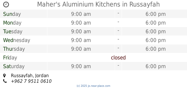
Maher's Aluminium Kitchens
Russayfah
Supermarket
read more
1.417 km
محلات الرقيب لقطع السيارات
Russayfah
Supermarket
read more
1.712 km
Super Market Aladasi
Russayfah
Supermarket
read more
2.166 km
محلات الكسواني
King Hussein Street, Az-Zarqa
Supermarket
read more
2.2 km
Al-Shiqbawy Market
Russayfah
Supermarket
read more
2.572 km
شركة البلد الطيب
Russayfah
Supermarket
read more
2.62 km
Al Madina supermarket
Az-Zarqa
Supermarket
read more
2.711 km
Aliassora and Dandis Furniture
Russayfah
Supermarket
read more
2.806 km
المؤسسة العسكرية / عوجان
Russayfah
Supermarket
read more
2.807 km
الشاكرين مول
لواء الرصيفة،, Russayfah
Supermarket
read more
3.067 km
Super Market Jerusalem
Army Street, Az-Zarqa
Supermarket
read more
3.075 km
Murad AlHalholy Super Market
شارع محمد بن خطار
Supermarket
read more
3.125 km
محلات الكسواني التجاريه
30, Az-Zarqa
Supermarket
read more
3.161 km
ميني ماركت حمادة
شارع وصفي التل،, Russayfah
Supermarket
read more
3.992 km
أسواق الحطيني
Az-Zarqa
Supermarket
read more
5.504 km
Mohammed Abu Hassan Trading Est
شارع المرابطون, عمّان, محافظة العاصمة, مؤسسة محمد الجبالي لقطع الشاحنات والسيارات, عمان ماركا الشماليه
Supermarket
read more
5.835 km
Farouk markets
Az-Zarqa
Supermarket
read more
📑
all categories
Accounting
Administrative area level 1
Administrative area level 2
Airport
Amusement park
Aquarium
Art gallery
Atm
Bakery
Bank
Bar
Beauty salon
Bicycle store
Book store
Bowling alley
Bus station
Cafe
Campground
Car dealer
Car rental
Car repair
Car wash
Cemetery
Church
City hall
Clothing store
Colloquial area
Convenience store
Country
Courthouse
Dentist
Department store
Doctor
Electrician
Electronics store
Embassy
Finance
Fire station
Florist
Food
Funeral home
Furniture store
Gas station
General contractor
Grocery or supermarket
Gym
Hair care
Hardware store
Health
Home goods store
Hospital
Insurance agency
Jewelry store
Laundry
Lawyer
Library
Liquor store
Local government office
Locality
Locksmith
Lodging
Meal delivery
Meal takeaway
Mosque
Movie rental
Movie theater
Moving company
Museum
Natural feature
Neighborhood
Night club
Painter
Park
Parking
Pet store
Pharmacy
Physiotherapist
Place of worship
Plumber
Point of interest
Police
Post office
Premise
Real estate agency
Restaurant
Route
Rv park, camping
School
Shoe store
Shopping mall
Spa
Stadium
Storage
Store
Supermarket
Taxi stand
Train station
Travel agency
University
Veterinary care
Zoo
sublocality level 1
↑