Supermarket nearby أسواق قرير Qareer Market
Jordan
Supermarket nearby أسواق قرير Qareer Market
أسواق قرير Qareer Market
Суайл, Амман, Иордания
contacts phone
:
+962 7 9600 7171
Latitude:
32.0253592
, Longitude:
35.8453839
larger map & directions
read more
nearest Supermarket
293 m
محطة الرائد العربي لخدمة السيارات
King Abdullah II Street, Amman
Supermarket
read more
308 m
Taleb Supermarket
Hesham Ben Al-A'as Street, Amman
Supermarket
read more
422 m
سوبر ماركت أبو حافظ
Amman
Supermarket
read more
436 m
ابو حافظ للبهارات والزعتر
30, Amman
Supermarket
read more
471 m
supermarket majed
Amman
Supermarket
read more
541 m
Sweileh corner grocery
Amman
Supermarket
read more
544 m
Al-Mazar Supermarket
Amman
Supermarket
read more
565 m
Abu Jamal supermarket
Amman
Supermarket
read more
607 m
سوبر ماركت أبو جعفر
Amman
Supermarket
read more
641 m
محلات العجوري للمواد التموينيه
Amman
Supermarket
read more
641 m
محلات العجوري
Amman
Supermarket
read more
689 m
Military Consumer Corporation
Amman
Supermarket
read more
946 m
Rami Supermarket
Kenaz Ben Al-Hussein Street, Amman
Supermarket
read more
1.082 km
سوبر ماركت أبو رمان
Amman
Supermarket
read more
1.22 km
خرابيش محل
Salman Al-Kayed Street, Amman
Supermarket
read more
1.347 km
Sky سوبر ماركت
Amman
Supermarket
read more
1.448 km
Safeway
Yajuz, Amman
Supermarket
read more
1.449 km
Amjad Al Balbesy Super Market
Amman
Supermarket
read more
1.489 km
Al-Rajebi Commercial markets
Amman
Supermarket
read more
1.807 km
ظفار وحذيفه
Amman
Supermarket
read more
1.883 km
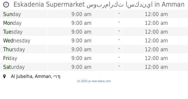
Eskadenia Supermarket سوبرماركت اسكدنيا
Amman
Supermarket
read more
2.023 km
حي البلدية ميني ماركت
Al Baladiyah, Amman
Supermarket
read more
2.284 km
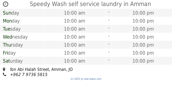
Speedy Wash self service laundry
Ibn Abi Halah Street, Amman
Supermarket
read more
2.455 km
511 MAll
tlaa alaly uhod street, Amman
Supermarket
read more
2.475 km
12
Amman
Supermarket
read more
📑
all categories
Accounting
Administrative area level 1
Administrative area level 2
Airport
Amusement park
Aquarium
Art gallery
Atm
Bakery
Bank
Bar
Beauty salon
Bicycle store
Book store
Bowling alley
Bus station
Cafe
Campground
Car dealer
Car rental
Car repair
Car wash
Cemetery
Church
City hall
Clothing store
Colloquial area
Convenience store
Country
Courthouse
Dentist
Department store
Doctor
Electrician
Electronics store
Embassy
Finance
Fire station
Florist
Food
Funeral home
Furniture store
Gas station
General contractor
Grocery or supermarket
Gym
Hair care
Hardware store
Health
Home goods store
Hospital
Insurance agency
Jewelry store
Laundry
Lawyer
Library
Liquor store
Local government office
Locality
Locksmith
Lodging
Meal delivery
Meal takeaway
Mosque
Movie rental
Movie theater
Moving company
Museum
Natural feature
Neighborhood
Night club
Painter
Park
Parking
Pet store
Pharmacy
Physiotherapist
Place of worship
Plumber
Point of interest
Police
Post office
Premise
Real estate agency
Restaurant
Route
Rv park, camping
School
Shoe store
Shopping mall
Spa
Stadium
Storage
Store
Supermarket
Taxi stand
Train station
Travel agency
University
Veterinary care
Zoo
sublocality level 1
↑