Supermarket nearby Anas Supermarket
Jordan
Supermarket nearby Anas Supermarket
Anas Supermarket
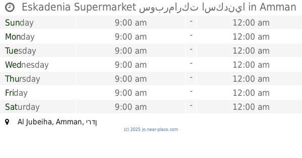
Tibnah Street, Amman, JO ירדן
contacts phone
:
+962 7 9707 9651
Latitude:
32.0292389
, Longitude:
35.8761992
larger map & directions
read more
nearest Supermarket
185 m
Supermarket Altroyhh
Amman
Supermarket
read more
318 m
Jawharet Al Jubeiha Supermarket
Complex No 3, Wahran St 3, Amman
Supermarket
read more
420 m
Manhal Supermarket
الجبيهه دوار المنهل
Supermarket
read more
841 m
Carrefour
Yajouz Road, Amman
Supermarket
read more
1.112 km
Zaid & Fares Supermarket
Amman
Supermarket
read more
1.16 km
Eskadenia Supermarket سوبرماركت اسكدنيا
Amman
Supermarket
read more
1.214 km
شونيز سوبر ماركت
Amman
Supermarket
read more
1.245 km
مياه كستنا
Abdallah Ali Al-Lawzi Street, Amman
Supermarket
read more
1.329 km
سوبر ماركت
Amman
Supermarket
read more
1.345 km
سوبر ماركت اهلا سهلا
Amman
Supermarket
read more
1.359 km
حي البلدية ميني ماركت
Al Baladiyah, Amman
Supermarket
read more
1.359 km
حي البلدية ميني ماركت
Amman
Supermarket
read more
1.452 km
Al-Rajebi Commercial markets
Amman
Supermarket
read more
1.502 km
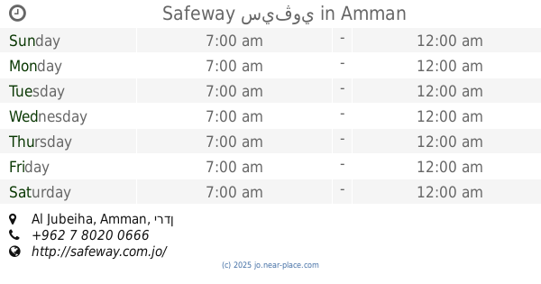
Safeway
Yajuz, Amman
Supermarket
read more
1.689 km
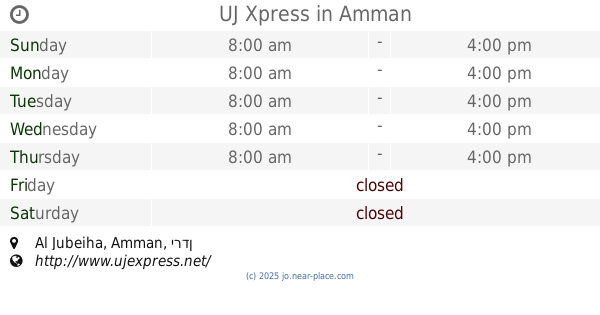
UJ Xpress
Amman
Supermarket
read more
1.709 km
Safeway سيڤوي
Amman
Supermarket
read more
1.795 km
The Village
Amman
Supermarket
read more
1.812 km
T&A
Khalil As-Saket Street 44،, Amman
Supermarket
read more
1.816 km
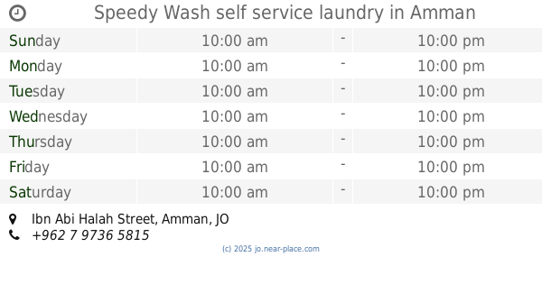
Speedy Wash self service laundry
Ibn Abi Halah Street, Amman
Supermarket
read more
2.223 km
سوبر ماركت زهرة الحي
شارع مقبل العبدللات،، عمّان
Supermarket
read more
2.494 km
Abu Nsseir Water
Khouri & Haddad Complex, Al Arab St 47, Amman
Supermarket
read more
2.61 km
سوبرماركت مشاوير
Al-Arab Street, Amman
Supermarket
read more
2.76 km
سوبر ماركت محمود
Amman
Supermarket
read more
3.483 km
دكان ابو عصام
Shafa Bardan, Amman
Supermarket
read more
3.841 km
Super Market God help
Supermarket
read more
📑
all categories
Accounting
Administrative area level 1
Administrative area level 2
Airport
Amusement park
Aquarium
Art gallery
Atm
Bakery
Bank
Bar
Beauty salon
Bicycle store
Book store
Bowling alley
Bus station
Cafe
Campground
Car dealer
Car rental
Car repair
Car wash
Cemetery
Church
City hall
Clothing store
Colloquial area
Convenience store
Country
Courthouse
Dentist
Department store
Doctor
Electrician
Electronics store
Embassy
Finance
Fire station
Florist
Food
Funeral home
Furniture store
Gas station
General contractor
Grocery or supermarket
Gym
Hair care
Hardware store
Health
Home goods store
Hospital
Insurance agency
Jewelry store
Laundry
Lawyer
Library
Liquor store
Local government office
Locality
Locksmith
Lodging
Meal delivery
Meal takeaway
Mosque
Movie rental
Movie theater
Moving company
Museum
Natural feature
Neighborhood
Night club
Painter
Park
Parking
Pet store
Pharmacy
Physiotherapist
Place of worship
Plumber
Point of interest
Police
Post office
Premise
Real estate agency
Restaurant
Route
Rv park, camping
School
Shoe store
Shopping mall
Spa
Stadium
Storage
Store
Supermarket
Taxi stand
Train station
Travel agency
University
Veterinary care
Zoo
sublocality level 1
↑