Store nearby صيدلية اورانج
Jordan
Store nearby صيدلية اورانج
صيدلية اورانج
Al Muqabalein, Amman, ירדן
contacts phone
:
+962
Latitude:
31.919763
, Longitude:
35.8604281
larger map & directions
read more
nearest Store
167 m
Mujahid Pharmacy
Amman
Store
read more
175 m
صيدلية المنجد
Amman
Store
read more
195 m
Al Shaeb Nuts
Manaseer Oil & Gas, Queen Alia Airport St 218, Amman
Store
read more
195 m
Al-Sha'b Roastery
Amman
Store
read more
1.122 km
SCOOP 1
ش. نالتشك،، عمّان
Store
read more
1.253 km
Sobh w Masa
Marj, Amman
Store
read more
1.527 km
Ramada Press
مرج الحمام, Amman
Store
read more
1.549 km
Frozen Food House
Abd Al Fattah Al Arakzeh Complex, Naltchek St 140, Amman
Store
read more
1.672 km
Hay Al-Sahabah Pharmacy
Amman
Store
read more
1.86 km
The Spider - Al3ankaboot
Amman Development Corridor, Amman
Store
read more
1.931 km
Pharmacy 1
Al Hai Sami Al Manaseer Complex, Naltchek St 162, Amman
Store
read more
2.005 km
Rujm Omiesh Pharmacy
Amman
Store
read more
2.05 km
The A Team
Amman
Store
read more
2.113 km
طبعتي للطباعة الحرارية و المواد الدعائية
Amman
Store
read more
2.113 km
طبعتي للمواد الدعائية و الطباعة الحرارية
Amman
Store
read more
2.201 km
Marj Al Hamam Dairy
Complex No 186, Naltchek St 186, Amman
Store
read more
2.382 km
Hikmat Yassin Marj Al Hammam
Marj Al Hammam, Jordan
Store
read more
2.506 km
Geo Clone
Al-Quds Street, Amman
Store
read more
2.881 km
Arafat Sweets
Adnan Center, Jabal Arafat St 53
Store
read more
2.942 km
Elite Auto Parts & Accessories
Unnamed Road, Amman
Store
read more
3.004 km
Al Awael Auto Parts
Amman
Store
read more
3.013 km
Scream For Mobile
Amman
Store
read more
3.043 km
CAR STARS , Car Accessories
Al-Ommal Street, Amman
Store
read more
3.5 km
Sunglass Hut Taj Mall
Prince Hashim Bin Al Hussein 693, Amman 11183, Amman
Store
read more
3.525 km
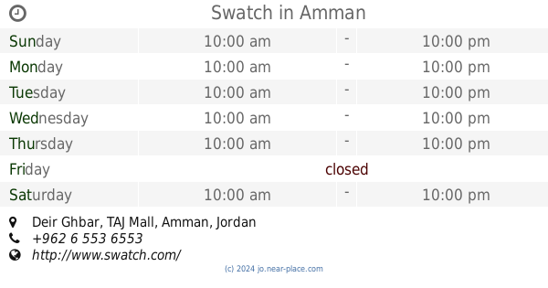
Swatch
Deir Ghbar, TAJ Mall, Amman
Store
read more
📑
all categories
Accounting
Administrative area level 1
Administrative area level 2
Airport
Amusement park
Aquarium
Art gallery
Atm
Bakery
Bank
Bar
Beauty salon
Bicycle store
Book store
Bowling alley
Bus station
Cafe
Campground
Car dealer
Car rental
Car repair
Car wash
Cemetery
Church
City hall
Clothing store
Colloquial area
Convenience store
Country
Courthouse
Dentist
Department store
Doctor
Electrician
Electronics store
Embassy
Finance
Fire station
Florist
Food
Funeral home
Furniture store
Gas station
General contractor
Grocery or supermarket
Gym
Hair care
Hardware store
Health
Home goods store
Hospital
Insurance agency
Jewelry store
Laundry
Lawyer
Library
Liquor store
Local government office
Locality
Locksmith
Lodging
Meal delivery
Meal takeaway
Mosque
Movie rental
Movie theater
Moving company
Museum
Natural feature
Neighborhood
Night club
Painter
Park
Parking
Pet store
Pharmacy
Physiotherapist
Place of worship
Plumber
Point of interest
Police
Post office
Premise
Real estate agency
Restaurant
Route
Rv park, camping
School
Shoe store
Shopping mall
Spa
Stadium
Storage
Store
Supermarket
Taxi stand
Train station
Travel agency
University
Veterinary care
Zoo
sublocality level 1
↑