Store nearby معمل البان الامين
Coronavirus disease (COVID-19) Situation
confirmed cases
1746997
deaths
14122
Jordan
Store nearby معمل البان الامين
معمل البان الامين
Zarqa Qasabah District, Az-Zarqa Israel
contacts phone
:
+962
Latitude:
32.0736153
, Longitude:
36.0373349
read more
nearest Store
2.093 km
مكتبة برزس للقرطاسية و الهدايا
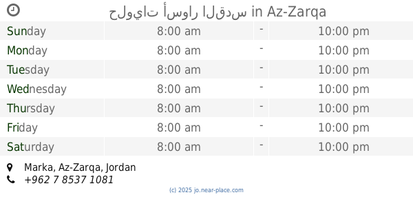
Az-Zarqa
Store
read more
2.792 km
حلويات أسوار القدس
Az-Zarqa
Store
read more
3.12 km
Al Faqir Pharmacy
Unnamed Road, Az-Zarqa
Store
read more
3.578 km
محلات ليان للتكييف والتبريد
Unnamed Road
Store
read more
3.602 km
محامص ابو طافش
Az-Zarqa
Store
read more
3.632 km
مسمكة ابو خليفة
حي معصوم شارع الفاروق
Store
read more
3.685 km
مراسي للاسمنت و الحديد
طريق جرش الدولي بعد دوار حي معصوم باتجاه طريق جرش الدولي
Store
read more
4.4 km
الشعلة للأدوات الصحية والدهانات
لواء الرصيفة،, Russayfah
Store
read more
4.55 km
اعمدة البيت لتجارة الاخشاب
Az-Zarqa
Store
read more
4.83 km
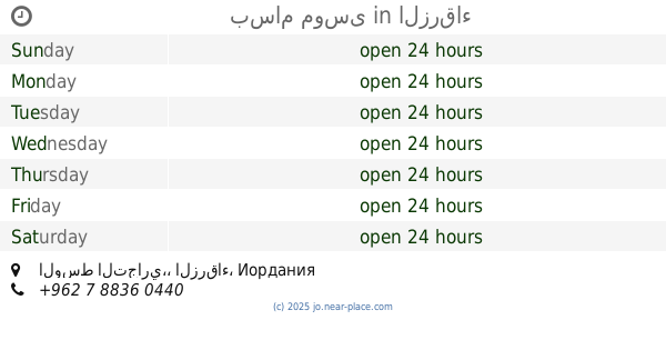
بسام موسى
الوسط التجاري،، الزرقاء
Store
read more
4.833 km
Muhanna Sweets Levantine
Az-Zarqa
Store
read more
4.844 km
Hamouda Library
Bab Al-Wad Street, Az-Zarqa
Store
read more
4.869 km
ICU for smokers
Az-Zarqa
Store
read more
4.917 km
Namrouti Building Materials
Yajouz Road, Russayfah
Store
read more
4.978 km
Alnajmah Sweets
Russayfah
Store
read more
4.997 km
الثقة للادوات الصحية
Az-Zarqa
Store
read more
4.999 km
Horizon Optics Center
Az-Zarqa
Store
read more
5.001 km
الصافي للبصريات
لواء الرصيفة،, Russayfah
Store
read more
5.008 km
مركز بيبلوس للصوتيات
Az-Zarqa
Store
read more
5.026 km
محل فلور لمواد التجميل ولوازم الصالونات.
King Talal Street, Amman
Store
read more
5.09 km
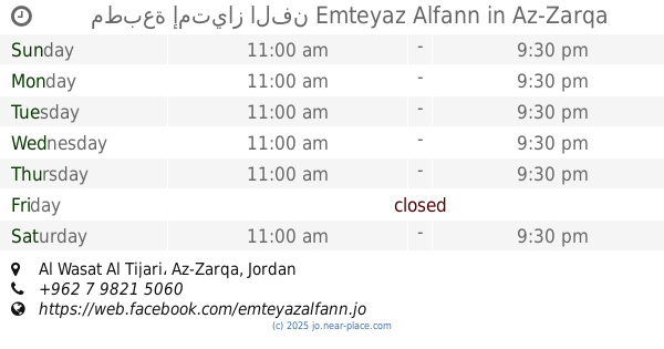
مطبعة إمتياز الفن Emteyaz Alfann
Al Wasat Al Tijari, Az-Zarqa
Store
read more
5.136 km
صيدلية دواء الصحة
Russayfah
Store
read more
5.56 km
Coffee son Bashiq
Az-Zarqa
Store
read more
5.931 km
Ayman Alqbawi replaced
30, Az-Zarqa
Store
read more
6.007 km
مطبعة الحجاوي
Russayfah
Store
read more
📑
all categories
Accounting
Administrative area level 1
Administrative area level 2
Airport
Amusement park
Aquarium
Art gallery
Atm
Bakery
Bank
Bar
Beauty salon
Bicycle store
Book store
Bowling alley
Bus station
Cafe
Campground
Car dealer
Car rental
Car repair
Car wash
Cemetery
Church
City hall
Clothing store
Colloquial area
Convenience store
Country
Courthouse
Dentist
Department store
Doctor
Electrician
Electronics store
Embassy
Finance
Fire station
Florist
Food
Funeral home
Furniture store
Gas station
General contractor
Grocery or supermarket
Gym
Hair care
Hardware store
Health
Home goods store
Hospital
Insurance agency
Jewelry store
Laundry
Lawyer
Library
Liquor store
Local government office
Locality
Locksmith
Lodging
Meal delivery
Meal takeaway
Mosque
Movie rental
Movie theater
Moving company
Museum
Natural feature
Neighborhood
Night club
Painter
Park
Parking
Pet store
Pharmacy
Physiotherapist
Place of worship
Plumber
Point of interest
Police
Post office
Premise
Real estate agency
Restaurant
Route
Rv park, camping
School
Shoe store
Shopping mall
Spa
Stadium
Storage
Store
Supermarket
Taxi stand
Train station
Travel agency
University
Veterinary care
Zoo
sublocality level 1
↑