Shopping mall nearby Supermarket Karama
Jordan
Shopping mall nearby Supermarket Karama
Supermarket Karama
Az-Zarqa Israel
contacts phone
:
+962
Latitude:
32.0947475
, Longitude:
36.0871586
read more
nearest Shopping mall
246 m
Falah Supermarket
شارع الكرامه
Shopping mall
read more
329 m
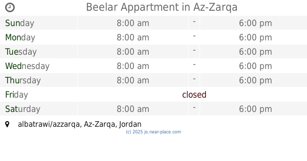
Beelar Appartment
albatrawi/azzarqa, Az-Zarqa
Shopping mall
read more
456 m
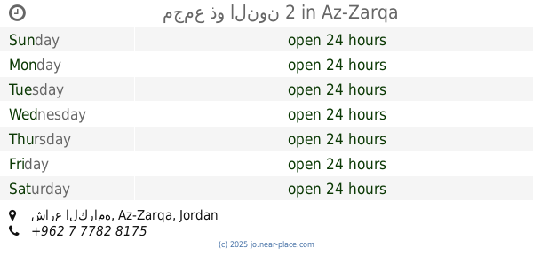
مجمع ذو النون 2
شارع الكرامه, Az-Zarqa
Shopping mall
read more
474 m
JK Stores
Az-Zarqa
Shopping mall
read more
638 m
Serer alsharq smokr shop
Ma'soum Circle, Az-Zarqa
Shopping mall
read more
725 m
Al Ain Mart
البتراوي، الزرقاء
Shopping mall
read more
766 m
سوبر ماركت الماجد
البتراوي،, Az-Zarqa
Shopping mall
read more
873 m
محلات ابوشعيب لتجارة الاخشاب والقرميد
الجديدة،، الزرقاء
Shopping mall
read more
880 m
AlKhadrawi rolling shutters and curtains
Az-Zarqa
Shopping mall
read more
892 m
Blue New markets
Az-Zarqa
Shopping mall
read more
911 m
Mutah Mall Fruits & Vegetables
Az-Zarqa
Shopping mall
read more
977 m
Nabek Housing
Al-Saadeh Street, Az-Zarqa
Shopping mall
read more
983 m
Salon Leah
Az-Zarqa
Shopping mall
read more
998 m
مجمع قواديس ش مكه.
الجديدة مجمع قواديس
Shopping mall
read more
1.024 km
مركز الصقر للاراجيل
Az-Zarqa
Shopping mall
read more
1.058 km
Oscar Grocery
Army Street, Az-Zarqa
Shopping mall
read more
1.111 km
مطاحن بن النصر الزرقاء الجديدة
شارع مكة،، الزرقاء
Shopping mall
read more
1.215 km
سوبرماركت شومان
Az-Zarqa
Shopping mall
read more
1.217 km
للاراجيل Al Rawaqan
شارع مكة،, Az-Zarqa
Shopping mall
read more
1.254 km
نهفات الزرقاء الجديده
Az-Zarqa
Shopping mall
read more
1.273 km
Green Beauty Shop جرين
Mecca Street, Az-Zarqa
Shopping mall
read more
1.531 km
Optikos Noor Moon
Az-Zarqa
Shopping mall
read more
1.802 km
Swan Lake 36
Az-Zarqa
Shopping mall
read more
1.804 km
Jerash Central Dairy
Az-Zarqa
Shopping mall
read more
1.97 km
Jewel Mall
Az-Zarqa
Shopping mall
read more
📑
all categories
Accounting
Administrative area level 1
Administrative area level 2
Airport
Amusement park
Aquarium
Art gallery
Atm
Bakery
Bank
Bar
Beauty salon
Bicycle store
Book store
Bowling alley
Bus station
Cafe
Campground
Car dealer
Car rental
Car repair
Car wash
Cemetery
Church
City hall
Clothing store
Colloquial area
Convenience store
Country
Courthouse
Dentist
Department store
Doctor
Electrician
Electronics store
Embassy
Finance
Fire station
Florist
Food
Funeral home
Furniture store
Gas station
General contractor
Grocery or supermarket
Gym
Hair care
Hardware store
Health
Home goods store
Hospital
Insurance agency
Jewelry store
Laundry
Lawyer
Library
Liquor store
Local government office
Locality
Locksmith
Lodging
Meal delivery
Meal takeaway
Mosque
Movie rental
Movie theater
Moving company
Museum
Natural feature
Neighborhood
Night club
Painter
Park
Parking
Pet store
Pharmacy
Physiotherapist
Place of worship
Plumber
Point of interest
Police
Post office
Premise
Real estate agency
Restaurant
Route
Rv park, camping
School
Shoe store
Shopping mall
Spa
Stadium
Storage
Store
Supermarket
Taxi stand
Train station
Travel agency
University
Veterinary care
Zoo
sublocality level 1
↑