School nearby School evidence model
Jordan
School nearby School evidence model
School evidence model
אירביד, ירדן
contacts phone
:
+962
Latitude:
32.5063663
, Longitude:
35.9104976
larger map & directions
read more
nearest School
867 m
مدرسة ابو حنيفة الثانوية للبنين
School
read more
1.007 km
Kindergarten School Educational Mortaqa
School
read more
1.097 km
روضة واكاديمية النهروان النموذجية
Al Tarkhees Street
School
read more
1.125 km
Basic School for Girls Khansa frank
Al Tarkhees Street
School
read more
1.589 km
Baraa School
School
read more
1.665 km
مدرسة عمار بن ياسر الاساسيه للبنين
School
read more
1.82 km
Frank Elementary School for Boys
School
read more
1.858 km
Ilona School
School
read more
1.953 km
As-Sarih Secondary Comprehensive School for Girls
As-Sarih
School
read more
2.071 km
International Grand Academy الاكديميه الكبرى الدوليه
Petra Street, Ramtha
School
read more
2.335 km
مدرسة الجسور
School
read more
2.367 km
Bridges Academy Schools And Kindergarten
School
read more
2.664 km
Huwwara Quranic
Bilal Ben Rabah Street محافظة, Irbid
School
read more
2.76 km
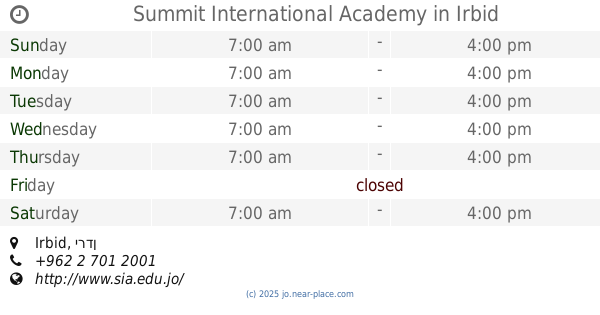
Summit International Academy
Irbid
School
read more
2.898 km
البلقاء التطبيقية الحصن
School
read more
2.9 km
Omar Al-Lafi High School for boys
25
School
read more
2.982 km
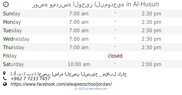
روضة ومدرسة الوجيز النموذجية
الأردن اربد الحصن, إشارة الحصن الصريح _ مقابل كراج القدس _ خلف صالون الأقصى, Al-Husun
School
read more
2.985 km
Al Tatbikat School
10, Huwwarah
School
read more
3.092 km
shoaaa.alamal school مدرسة شعاع الامل
Almorad St, Elsssareh, Irbid
School
read more
3.225 km
Al-Huson High School for Girls
As-Sarih
School
read more
3.38 km
مدارس الأحد الحديثة - Sunday modern school
School
read more
3.767 km
Abbas Bin Firnas School
School
read more
3.999 km
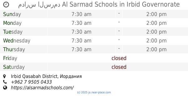
مدارس السرمد Al Sarmad Schools
School
read more
3.999 km
مدارس السرمد Al Sarmad Schools
Irbid Qasabah District
School
read more
4.027 km
جمعية الحصن الخيريه الاسلاميه
School
read more
📑
all categories
Accounting
Administrative area level 1
Administrative area level 2
Airport
Amusement park
Aquarium
Art gallery
Atm
Bakery
Bank
Bar
Beauty salon
Bicycle store
Book store
Bowling alley
Bus station
Cafe
Campground
Car dealer
Car rental
Car repair
Car wash
Cemetery
Church
City hall
Clothing store
Colloquial area
Convenience store
Country
Courthouse
Dentist
Department store
Doctor
Electrician
Electronics store
Embassy
Finance
Fire station
Florist
Food
Funeral home
Furniture store
Gas station
General contractor
Grocery or supermarket
Gym
Hair care
Hardware store
Health
Home goods store
Hospital
Insurance agency
Jewelry store
Laundry
Lawyer
Library
Liquor store
Local government office
Locality
Locksmith
Lodging
Meal delivery
Meal takeaway
Mosque
Movie rental
Movie theater
Moving company
Museum
Natural feature
Neighborhood
Night club
Painter
Park
Parking
Pet store
Pharmacy
Physiotherapist
Place of worship
Plumber
Point of interest
Police
Post office
Premise
Real estate agency
Restaurant
Route
Rv park, camping
School
Shoe store
Shopping mall
Spa
Stadium
Storage
Store
Supermarket
Taxi stand
Train station
Travel agency
University
Veterinary care
Zoo
sublocality level 1
↑