School nearby School
Jordan
School nearby School
School
Al Muwahidin, Irbid, Irbid Qasabah District, JO ירדן
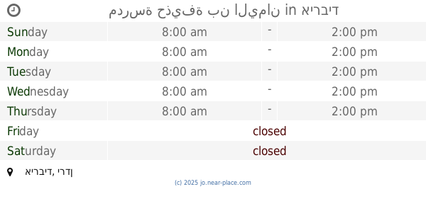
contacts phone
:
+962
Latitude:
32.5554135
, Longitude:
35.8798617
larger map & directions
read more
nearest School
261 m
Basic dignity school district
Irbid
School
read more
555 m
School Aisha bin Abi Bakr basic mixed
Amman Street, Irbid
School
read more
628 m
Alosos Modern Academy School
Irbid
School
read more
635 m
School
Samar Street, Irbid
School
read more
718 m
مدرسة حديقة تونس الأساسية للبنات
Irbid
School
read more
855 m
Apostles School of Educational Excellence
Irbid
School
read more
876 m
المرصد الوطني الاردني لحقوق الانسان
Qasr Al-Hamraa Street, Irbid
School
read more
991 m
مدارس اكاديمية القصور
School
read more
1.014 km
مدرسة زين الأمل
Irbid
School
read more
1.017 km
Zain Al-amal School
Bushra Sal Travelling Complex, Bushra, Irbid
School
read more
1.02 km
مسجد القدس اربد
Irbid
School
read more
1.05 km
School
Muta, Irbid
School
read more
1.153 km
School of the pioneers of educational science
Irbid
School
read more
1.347 km
Educational Excellence Academy Schools
Irbid
School
read more
1.487 km
اكاديميةالاسس النموذجية
Halab Street, Irbid
School
read more
1.501 km
big heart kindergarten
Al-Andalus Street, Irbid
School
read more
1.512 km
مدرسة النور التربوية الاسلامية
Irbid
School
read more
1.522 km
Fatima Zahra Secondary School for Girls
Irbid
School
read more
1.676 km
Emdad Academy
Irbid
School
read more
1.837 km
Irbid Modern School
Qays Bin Malik, Irbid
School
read more
1.861 km
Mindfulness School
School
read more
1.961 km
مدرسة حذيفة بن اليمان
Irbid
School
read more
2.186 km
روضة و مدرسة الإيمان التعليمية
Rateb Al-Battayenah Street, Irbid
School
read more
2.196 km
حضانة حبايبنا
Irbid
School
read more
2.336 km
Online Academy
Irbid
School
read more
📑
all categories
Accounting
Administrative area level 1
Administrative area level 2
Airport
Amusement park
Aquarium
Art gallery
Atm
Bakery
Bank
Bar
Beauty salon
Bicycle store
Book store
Bowling alley
Bus station
Cafe
Campground
Car dealer
Car rental
Car repair
Car wash
Cemetery
Church
City hall
Clothing store
Colloquial area
Convenience store
Country
Courthouse
Dentist
Department store
Doctor
Electrician
Electronics store
Embassy
Finance
Fire station
Florist
Food
Funeral home
Furniture store
Gas station
General contractor
Grocery or supermarket
Gym
Hair care
Hardware store
Health
Home goods store
Hospital
Insurance agency
Jewelry store
Laundry
Lawyer
Library
Liquor store
Local government office
Locality
Locksmith
Lodging
Meal delivery
Meal takeaway
Mosque
Movie rental
Movie theater
Moving company
Museum
Natural feature
Neighborhood
Night club
Painter
Park
Parking
Pet store
Pharmacy
Physiotherapist
Place of worship
Plumber
Point of interest
Police
Post office
Premise
Real estate agency
Restaurant
Route
Rv park, camping
School
Shoe store
Shopping mall
Spa
Stadium
Storage
Store
Supermarket
Taxi stand
Train station
Travel agency
University
Veterinary care
Zoo
sublocality level 1
↑