School nearby Mushayrifah Elementary School mixed
Jordan
School nearby Mushayrifah Elementary School mixed
Mushayrifah Elementary School mixed
Эль-Мафрак, Иордания
contacts phone
:
+962
Latitude:
32.486849
, Longitude:
36.12425
larger map & directions
read more
nearest School
2.988 km
مدرسة السويلمة الثانوية للبنات
School
read more
3.426 km
مركز تحفيظ القرآن الكريم
School
read more
3.589 km
مدرسة الاكيدر الثانوية للبنين
School
read more
3.838 km
مدرسة الاكيدر الثانوية للبنات
School
read more
3.849 km
مدرسة الدندنية الاساسية للبنين
School
read more
4.652 km
مدرسة حوشا الاساسية المختلطة
School
read more
4.736 km
مدرسة حوشا الثانوية للبنين
Hawshah
School
read more
4.765 km
مدرسة حوشا الثانوية للاناث
School
read more
6.204 km
A fourth school Altip basic
School
read more
6.524 km
Hock Elementary School
School
read more
6.614 km
مدرسة البويضه الثانوبه للبنات
School
read more
11.056 km
اكاديمية ومدارس الثروة العلمية
Ramtha
School
read more
12.543 km
Independence School
Ramtha
School
read more
12.611 km
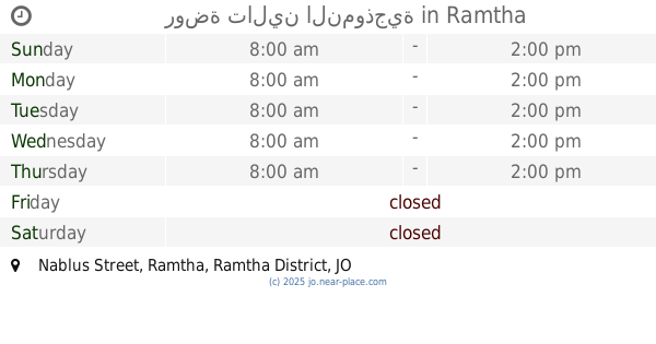
روضة تالين النموذجية
Nablus Street, Ramtha
School
read more
12.66 km
Al Etemad International School مدارس الاعتماد الدولية
Ar Ramtha
School
read more
12.894 km
حضانة تعليمية
Ramtha
School
read more
13.19 km
Arqam Elementary School
Ekremah Street, Ramtha
School
read more
13.401 km
مدرسة ميمونة بنت الحارث للبنات
Ramtha
School
read more
13.607 km
مدرة جمانة بنت ابي طاب
Ramtha
School
read more
13.699 km
مدرسة بلال بن رباح
Ramtha
School
read more
13.77 km
سكينة بنت الحسين الثانوية للبنات
Sukeinah Bent Al-Hussein Street, Ramtha
School
read more
13.966 km
Ibn Hazm Elementary School مدرسة ابن حزم الأساسية للبنين
,الحي الغربي, Ramtha
School
read more
14.381 km
Abu Dujana Center
Ramtha
School
read more
16.284 km
مدرسة انساني الاساسية
Al, Al-Mafraq
School
read more
16.527 km
مدرسة ابو عبيدة عامر بن الجراح
Al-Mafraq
School
read more
📑
all categories
Accounting
Administrative area level 1
Administrative area level 2
Airport
Amusement park
Aquarium
Art gallery
Atm
Bakery
Bank
Bar
Beauty salon
Bicycle store
Book store
Bowling alley
Bus station
Cafe
Campground
Car dealer
Car rental
Car repair
Car wash
Cemetery
Church
City hall
Clothing store
Colloquial area
Convenience store
Country
Courthouse
Dentist
Department store
Doctor
Electrician
Electronics store
Embassy
Finance
Fire station
Florist
Food
Funeral home
Furniture store
Gas station
General contractor
Grocery or supermarket
Gym
Hair care
Hardware store
Health
Home goods store
Hospital
Insurance agency
Jewelry store
Laundry
Lawyer
Library
Liquor store
Local government office
Locality
Locksmith
Lodging
Meal delivery
Meal takeaway
Mosque
Movie rental
Movie theater
Moving company
Museum
Natural feature
Neighborhood
Night club
Painter
Park
Parking
Pet store
Pharmacy
Physiotherapist
Place of worship
Plumber
Point of interest
Police
Post office
Premise
Real estate agency
Restaurant
Route
Rv park, camping
School
Shoe store
Shopping mall
Spa
Stadium
Storage
Store
Supermarket
Taxi stand
Train station
Travel agency
University
Veterinary care
Zoo
sublocality level 1
↑