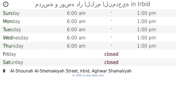
School nearby مدرسة و روضه دار الكرم
Jordan
School nearby مدرسة و روضه دار الكرم
مدرسة و روضه دار الكرم
אירביד, ירדן
contacts phone
:
+962
Latitude:
32.450169
, Longitude:
35.6055183
larger map & directions
read more
nearest School
3 m
مدرسة و روضه دار الكرم النمذجية
Al-Shounah Al-Shemaleyah Street, Irbid
School
read more
963 m
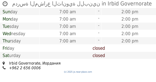
مدرسة ذكور وإناث المشارع الإعدادية / الوكالة
School
read more
983 m
مدرسة المشارع الثانوية للبنات
School
read more
1.117 km
مدرسة المشارع الثانوية للبنين
School
read more
2.391 km
مدرسة أبو بكر الصديق للبنين
School
read more
2.474 km
مدرسة شرحبيل بن حسنة الأساسية للبنين
School
read more
5.089 km
مدرسة قليعات الثانوية المختلطة
الاردن للواء
School
read more
7.364 km
مسجدعمر ابن الخطاب ابوالقين
School
read more
7.89 km
Kufr'Awan Secondary Comprehensive School for Girls
School
read more
8.598 km
House EADS basic Mixed School
School
read more
9.383 km
مدرسة بيت ايدس الثانوية للبنات
School
read more
9.887 km
روضة المسك النموذجية
Irbid
School
read more
10.097 km
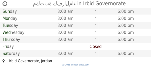
مكتبة كفرالماء
School
read more
10.412 km
مدرسة عبدالله بن رواحة الاساسية للبنين
School
read more
10.921 km
مدرسة جديتا المتوسطة للبنات
Judayta
School
read more
11.081 km
Hashemite Secondary Girls School
Ajloun
School
read more
12.011 km
Tbneh school
School
read more
14.218 km
مدرسة نسيبة المازنية - الطيبة
School
read more
14.846 km
مدرسة رقية بنت الرسول الاساسية للبنات
School
read more
15.192 km
صما الحي الشرقي المحجه
School
read more
16.158 km
دير السعنة الثانوية للبنين
Dayr as Si'nah
School
read more
16.374 km
مدرسة ديرالسعنة الثانوية للبنات
Hizam Ring Road, Amman
School
read more
18.182 km
مدرسة مكه الثانوية للبنين
School
read more
18.716 km
مدرسة القلعة الاساسية المختلطة
Ajloun
School
read more
19.195 km
مدرسه الملك الناصر
Ajloun
School
read more
📑
all categories
Accounting
Administrative area level 1
Administrative area level 2
Airport
Amusement park
Aquarium
Art gallery
Atm
Bakery
Bank
Bar
Beauty salon
Bicycle store
Book store
Bowling alley
Bus station
Cafe
Campground
Car dealer
Car rental
Car repair
Car wash
Cemetery
Church
City hall
Clothing store
Colloquial area
Convenience store
Country
Courthouse
Dentist
Department store
Doctor
Electrician
Electronics store
Embassy
Finance
Fire station
Florist
Food
Funeral home
Furniture store
Gas station
General contractor
Grocery or supermarket
Gym
Hair care
Hardware store
Health
Home goods store
Hospital
Insurance agency
Jewelry store
Laundry
Lawyer
Library
Liquor store
Local government office
Locality
Locksmith
Lodging
Meal delivery
Meal takeaway
Mosque
Movie rental
Movie theater
Moving company
Museum
Natural feature
Neighborhood
Night club
Painter
Park
Parking
Pet store
Pharmacy
Physiotherapist
Place of worship
Plumber
Point of interest
Police
Post office
Premise
Real estate agency
Restaurant
Route
Rv park, camping
School
Shoe store
Shopping mall
Spa
Stadium
Storage
Store
Supermarket
Taxi stand
Train station
Travel agency
University
Veterinary care
Zoo
sublocality level 1
↑