School nearby مدرسة نتل الثانوية للبنين
Jordan
School nearby مدرسة نتل الثانوية للبنين
مدرسة نتل الثانوية للبنين
نتل، عمّان، ישראל
contacts phone
:
+962
Latitude:
31.6493341
, Longitude:
35.8634788
read more
nearest School
3.918 km
School saffron 2
Amman
School
read more
4.078 km
School saffron
Amman
School
read more
6.187 km
Akram Kareem Hall - AUM
Madaba
School
read more
6.341 km
طه هواري طه علي السوعير
Madaba
School
read more
7.025 km
Secondary School Arainbeh West Secondary Mixed
Hizam Ring Road, Amman
School
read more
8.991 km
Kindergartens and schools evacuation Madaba Branch
Al-Watan Al-Arabi Street, Madaba
School
read more
9.285 km
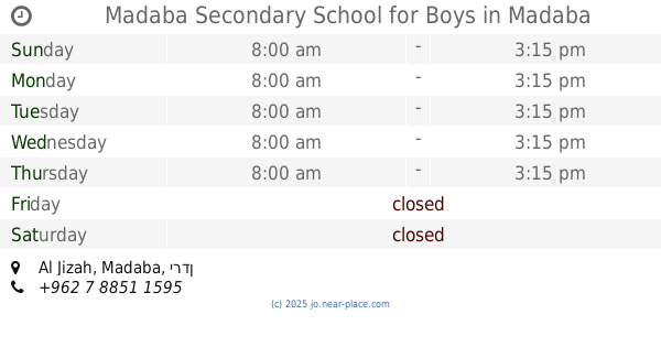
Madaba Secondary School for Boys
Madaba
School
read more
9.479 km
Rashidiya Elementary School Mixed
School
read more
9.491 km
مدرسة الخنساء
Madaba
School
read more
9.828 km
روضة زين ولينه التربوية الخاصة
Al-Quds Street, Madaba
School
read more
9.859 km
مدرسة مادبا المهنية الثانوية الشاملةللبنات
Al-Imam Hasan Al-Banna Street, Madaba
School
read more
10.122 km
Fatima Zahra Elementary School Mixed
Madaba
School
read more
10.342 km
Libb secondary school for boys
School
read more
10.473 km
مدرسة ذكور الطالبية
Amman
School
read more
10.638 km
School of the core of the basic
School
read more
10.758 km
Patriach Latin School
31°42'08.0"N 35°46'05., 7th Circle, Amman
School
read more
11.131 km
مدرسة الملك عبدالله للتميز
Madaba
School
read more
11.131 km
King Abdullah II School
Madaba
School
read more
11.163 km
Secondary School Pulp
School
read more
11.849 km
Bandar School
Madaba
School
read more
12.262 km
Zaytuna mixed Elementary School
Amman
School
read more
12.503 km
Qastal Secondary School For Girls
Amman
School
read more
12.678 km
Ma'in Secondary School for Boys
School
read more
13.12 km
مدرسة ماعين الابتدائية للبنين
School
read more
16.214 km
مدرسة غرناطة الاساسية للبنات
School
read more
📑
all categories
Accounting
Administrative area level 1
Administrative area level 2
Airport
Amusement park
Aquarium
Art gallery
Atm
Bakery
Bank
Bar
Beauty salon
Bicycle store
Book store
Bowling alley
Bus station
Cafe
Campground
Car dealer
Car rental
Car repair
Car wash
Cemetery
Church
City hall
Clothing store
Colloquial area
Convenience store
Country
Courthouse
Dentist
Department store
Doctor
Electrician
Electronics store
Embassy
Finance
Fire station
Florist
Food
Funeral home
Furniture store
Gas station
General contractor
Grocery or supermarket
Gym
Hair care
Hardware store
Health
Home goods store
Hospital
Insurance agency
Jewelry store
Laundry
Lawyer
Library
Liquor store
Local government office
Locality
Locksmith
Lodging
Meal delivery
Meal takeaway
Mosque
Movie rental
Movie theater
Moving company
Museum
Natural feature
Neighborhood
Night club
Painter
Park
Parking
Pet store
Pharmacy
Physiotherapist
Place of worship
Plumber
Point of interest
Police
Post office
Premise
Real estate agency
Restaurant
Route
Rv park, camping
School
Shoe store
Shopping mall
Spa
Stadium
Storage
Store
Supermarket
Taxi stand
Train station
Travel agency
University
Veterinary care
Zoo
sublocality level 1
↑