School nearby مدرسة ميسون الدمشقية الأساسية للبنات
Jordan
School nearby مدرسة ميسون الدمشقية الأساسية للبنات
مدرسة ميسون الدمشقية الأساسية للبنات
אירביד, ירדן
contacts phone
:
+962
Latitude:
32.5649703
, Longitude:
35.8685515
larger map & directions
read more
nearest School
180 m
روضة عشاق القمم
Qotoz Street, Irbid
School
read more
238 m
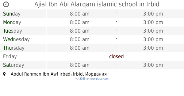
Ajial ibn aby alarqam school
Unnamed Rd
School
read more
238 m
Ajial Ibn Abi Alarqam islamic school
Abdul Rahman Ibn Awf irbed
School
read more
244 m
مدرسة اجيال ابن ابي الارقم الاسلامية
Irbid
School
read more
353 m
School of the pioneers of educational science
Irbid
School
read more
357 m
Fatima Zahra Secondary School for Girls
Irbid
School
read more
357 m
Emdad Academy
Irbid
School
read more
361 m
وكالة اربد الاعدادية الارابعة
Al-Iman Street, Irbid
School
read more
376 m
مدرسة ذكور و إناث إربد الإعدادية الرابعة والثانية
Irbid
School
read more
516 m
Walid bin Abdul Malik Secondary School for Boys
Irbid
School
read more
616 m
مدرسة عمر بن عبد العزيز الاساسية للبنين
Irbid
School
read more
646 m
مدرسة عمرة بن عبد العزيز
Irbid
School
read more
655 m
مدرسة بلال بن رباح
Irbid
School
read more
700 m
Omar Mukhtar Primary School
Al Rafidayn, Irbid
School
read more
713 m
Model School and Kindergarten Falcons
Irbid
School
read more
785 m
Educational Excellence Academy Schools
Irbid
School
read more
806 m
School and Kindergarten Sana Knowledge
Irbid
School
read more
808 m
Al-Nahda Private Schools
Al Hudaybiya, Irbid
School
read more
838 m
مركز التقوى القرآني
Irbid
School
read more
919 m
مدرسه ابوجعفر المنصور
Irbid
School
read more
931 m
Apostles School of Educational Excellence
Irbid
School
read more
977 m
مدرسة اﻷمل الثانوية الشاملة المختلطه للصم
Irbid
School
read more
1.052 km
مدرسة حديقة تونس الأساسية للبنات
Irbid
School
read more
1.066 km
مدرسة طبريا الثانوية للبنات
Irbid
School
read more
1.252 km
Basic dignity school district
Irbid
School
read more
📑
all categories
Accounting
Administrative area level 1
Administrative area level 2
Airport
Amusement park
Aquarium
Art gallery
Atm
Bakery
Bank
Bar
Beauty salon
Bicycle store
Book store
Bowling alley
Bus station
Cafe
Campground
Car dealer
Car rental
Car repair
Car wash
Cemetery
Church
City hall
Clothing store
Colloquial area
Convenience store
Country
Courthouse
Dentist
Department store
Doctor
Electrician
Electronics store
Embassy
Finance
Fire station
Florist
Food
Funeral home
Furniture store
Gas station
General contractor
Grocery or supermarket
Gym
Hair care
Hardware store
Health
Home goods store
Hospital
Insurance agency
Jewelry store
Laundry
Lawyer
Library
Liquor store
Local government office
Locality
Locksmith
Lodging
Meal delivery
Meal takeaway
Mosque
Movie rental
Movie theater
Moving company
Museum
Natural feature
Neighborhood
Night club
Painter
Park
Parking
Pet store
Pharmacy
Physiotherapist
Place of worship
Plumber
Point of interest
Police
Post office
Premise
Real estate agency
Restaurant
Route
Rv park, camping
School
Shoe store
Shopping mall
Spa
Stadium
Storage
Store
Supermarket
Taxi stand
Train station
Travel agency
University
Veterinary care
Zoo
sublocality level 1
↑