School nearby مدرسة جمعية الفاروق الخيرية للأيتام
Jordan
School nearby مدرسة جمعية الفاروق الخيرية للأيتام
مدرسة جمعية الفاروق الخيرية للأيتام
אירביד, ירדן
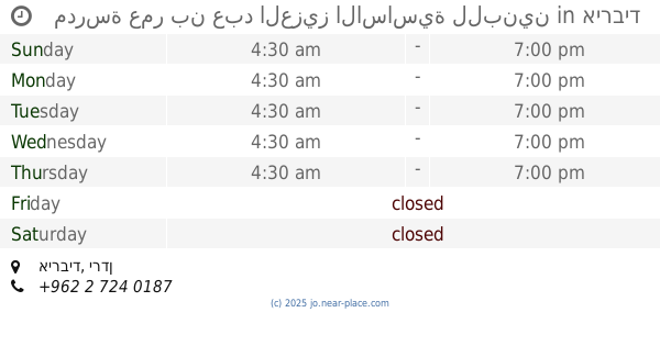
contacts phone
:
+962 2 727 5901
website:
www.alfarouqsociety.org
Latitude:
32.5657875
, Longitude:
35.8541021
larger map & directions
read more
nearest School
132 m
مدرسة إناث إربد الإعدادية الثالثة والرابعة
A'awdah, Irbid
School
read more
291 m
مدرسة ذات النطاقين الاساسية للبنات
Irbid
School
read more
321 m
School Irbid camp for boys
Irbid
School
read more
382 m
مدرسة اﻷمل الثانوية الشاملة المختلطه للصم
Irbid
School
read more
485 m
School
Dayr Al Ghusun, Irbid
School
read more
742 m
مدرسة بلال بن رباح
Irbid
School
read more
795 m
مدرسه انس بن مالك
Irbid
School
read more
842 m
Walid bin Abdul Malik Secondary School for Boys
Irbid
School
read more
853 m
مركز ريم الثقافي
حنينا, Al-Quds Street, Irbid
School
read more
862 m
Air Operator and cooling
Irbid
School
read more
864 m
Wasfi Al Tal Industrial School
Irbid
School
read more
906 m
كراج اصطفاف مدرسة وصفي التل الصناعية
Irbid
School
read more
906 m
مشغل الراديو و التلفاز / مدرسة وصفي التل الصناعية
Irbid
School
read more
913 m
Fuara UNRWA Preparatory School
Al-Ahrar Street, Irbid
School
read more
941 m
Turning / descriptive Industrial Hill School Operator
Irbid
School
read more
958 m
مدرسة عمر بن عبد العزيز الاساسية للبنين
Irbid
School
read more
968 m
مدرسة نفيسة بنتالحسن الثانوية للبنات
شارع القدس
School
read more
993 m
Mechanical vehicle / school descriptive hill operator
Irbid
School
read more
998 m
Irbid Secondary School for Boys
Irbid
School
read more
1.075 km
Al-Nahda Private Schools
Al Hudaybiya, Irbid
School
read more
1.141 km
مدرسه اربد التجاريه
Irbid
School
read more
1.141 km
Al Falah Building
Qasabah kufer youba, Irbid
School
read more
1.141 km
مدارس الإرث الذهبي
32°32'04.0"N 35°52'02.5"E
School
read more
1.141 km
مدرسة السيلة الثانوية للبنات
Irbid
School
read more
1.141 km
مدرسة إنسان النموذجية
اربد / شارع حكما /قرب ملاعب ارابيلا، إربد،
School
read more
📑
all categories
Accounting
Administrative area level 1
Administrative area level 2
Airport
Amusement park
Aquarium
Art gallery
Atm
Bakery
Bank
Bar
Beauty salon
Bicycle store
Book store
Bowling alley
Bus station
Cafe
Campground
Car dealer
Car rental
Car repair
Car wash
Cemetery
Church
City hall
Clothing store
Colloquial area
Convenience store
Country
Courthouse
Dentist
Department store
Doctor
Electrician
Electronics store
Embassy
Finance
Fire station
Florist
Food
Funeral home
Furniture store
Gas station
General contractor
Grocery or supermarket
Gym
Hair care
Hardware store
Health
Home goods store
Hospital
Insurance agency
Jewelry store
Laundry
Lawyer
Library
Liquor store
Local government office
Locality
Locksmith
Lodging
Meal delivery
Meal takeaway
Mosque
Movie rental
Movie theater
Moving company
Museum
Natural feature
Neighborhood
Night club
Painter
Park
Parking
Pet store
Pharmacy
Physiotherapist
Place of worship
Plumber
Point of interest
Police
Post office
Premise
Real estate agency
Restaurant
Route
Rv park, camping
School
Shoe store
Shopping mall
Spa
Stadium
Storage
Store
Supermarket
Taxi stand
Train station
Travel agency
University
Veterinary care
Zoo
sublocality level 1
↑