School nearby مدرسة دعم الغزالات
Jordan
School nearby مدرسة دعم الغزالات
مدرسة دعم الغزالات
Unnamed Rd, ירדן
contacts phone
:
+962
Latitude:
32.0894594
, Longitude:
35.744609
larger map & directions
read more
nearest School
809 m
مدرسة أم جوزة الثانوية الزراعية
School
read more
906 m
مدرسة ام جوزة للبنات
School
read more
2.319 km
Zay Secondary school For Boys
School
read more
2.53 km
Zay islamic school رورضه و مدرسه زي الاسلاميه
School
read more
2.646 km
مدرسة الغفران
Balqa
School
read more
2.653 km
Alghofran School
Balqa
School
read more
3.139 km
Mosque of Omar Ibn al-Khattab
Hizam Ring Road, Amman
School
read more
3.484 km
Habit Allah School
As Slat, As-Salt
School
read more
3.518 km
مدرسة تالا الخير النموذجية
As-Salt
School
read more
3.524 km
Abdel Hafez al-Azab School
Prince Hamza Street, As-Salt
School
read more
3.564 km
King Abdulla School for Excellence
As-Salt
School
read more
3.731 km
Little Team Academy
Rabieh Circle, Amman
School
read more
3.739 km
Reading International School
As-Salt
School
read more
4.36 km
Al Ka'as School
As-Salt
School
read more
4.416 km
مدرسة الياقوت التربوية
As-Salt
School
read more
4.445 km
مدرسة السلط الحديثة
As-Salt
School
read more
4.448 km
Aisha Bint Abi Bakr School
As-Salt
School
read more
4.458 km
مدرسة عائشة بنت ابي بكر الصديق
As-Salt
School
read more
4.802 km
مدرسة جمال الدين الافغاني
As-Salt
School
read more
5.025 km
مدرسة الحسناء الثانوية للبنات
As-Salt
School
read more
5.047 km
Al-Saifya Secondary School
Al-Bhira, As-Salt
School
read more
5.211 km
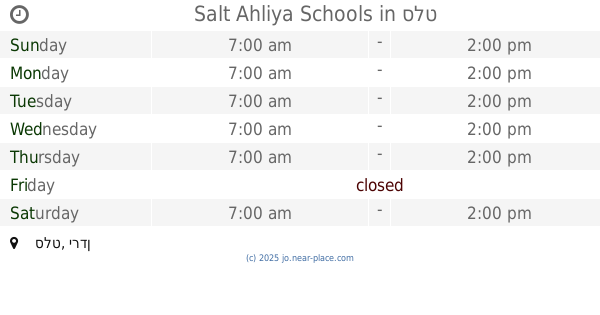
Salt Ahliya Schools
As-Salt
School
read more
5.294 km
مدرسة أديب وهبه الثانوية للبنين
As-Salt
School
read more
5.314 km
School Aremeiman Secondary Girls
School
read more
5.333 km
Rmaimeen Boys School
Jordan
School
read more
📑
all categories
Accounting
Administrative area level 1
Administrative area level 2
Airport
Amusement park
Aquarium
Art gallery
Atm
Bakery
Bank
Bar
Beauty salon
Bicycle store
Book store
Bowling alley
Bus station
Cafe
Campground
Car dealer
Car rental
Car repair
Car wash
Cemetery
Church
City hall
Clothing store
Colloquial area
Convenience store
Country
Courthouse
Dentist
Department store
Doctor
Electrician
Electronics store
Embassy
Finance
Fire station
Florist
Food
Funeral home
Furniture store
Gas station
General contractor
Grocery or supermarket
Gym
Hair care
Hardware store
Health
Home goods store
Hospital
Insurance agency
Jewelry store
Laundry
Lawyer
Library
Liquor store
Local government office
Locality
Locksmith
Lodging
Meal delivery
Meal takeaway
Mosque
Movie rental
Movie theater
Moving company
Museum
Natural feature
Neighborhood
Night club
Painter
Park
Parking
Pet store
Pharmacy
Physiotherapist
Place of worship
Plumber
Point of interest
Police
Post office
Premise
Real estate agency
Restaurant
Route
Rv park, camping
School
Shoe store
Shopping mall
Spa
Stadium
Storage
Store
Supermarket
Taxi stand
Train station
Travel agency
University
Veterinary care
Zoo
sublocality level 1
↑