School nearby مدرسة الوطنيه
Jordan
School nearby مدرسة الوطنيه
مدرسة الوطنيه
Jordan, 71454, Montgomery, Irbid Qasabah District, JO Иордания
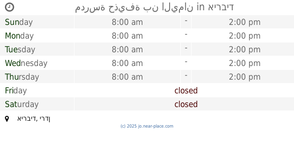
contacts phone
:
+962
Latitude:
32.555304
, Longitude:
35.848627
larger map & directions
read more
nearest School
186 m
School
Irbid
School
read more
196 m
مدارس الإرث الذهبي
32°32'04.0"N 35°52'02.5"E
School
read more
196 m
مدرسه اربد التجاريه
Irbid
School
read more
196 m
مدرسة السيلة الثانوية للبنات
Irbid
School
read more
196 m
مدرسة إنسان النموذجية
اربد / شارع حكما /قرب ملاعب ارابيلا، إربد،
School
read more
196 m
Al Falah Building
Qasabah kufer youba, Irbid
School
read more
342 m
Mechanical vehicle / school descriptive hill operator
Irbid
School
read more
405 m
Turning / descriptive Industrial Hill School Operator
Irbid
School
read more
441 m
مشغل الراديو و التلفاز / مدرسة وصفي التل الصناعية
Irbid
School
read more
461 m
Wasfi Al Tal Industrial School
Irbid
School
read more
478 m
كراج اصطفاف مدرسة وصفي التل الصناعية
Irbid
School
read more
490 m
Irbid Secondary School for Boys
Irbid
School
read more
530 m
Air Operator and cooling
Irbid
School
read more
533 m
Greek Catholic School for Shweries Sisters, مدرسة ثانوية الروم الكاثوليك للراهبات الشويريات
Al-Husun Irbid Street, beside Unoion Bank, ش. أربد الحسن، مقابل بنك, الاتحاد, Irbid
School
read more
536 m
مدرسة المأمون الاساسية للبنين
Irbid
School
read more
537 m
مدرسة المأمون
Irbid
School
read more
728 m
مدرسة سمخ
Irbid
School
read more
737 m
مدرسة سمخ الابتدائية
Irbid
School
read more
802 m
School
Dayr Al Ghusun, Irbid
School
read more
911 m
مدرسة رقية
Irbid
School
read more
966 m
مدرسة حذيفة بن اليمان
Irbid
School
read more
980 m
School Al Andalus
حي المطلع شارع فوعرا, Irbid
School
read more
986 m
Kindergarten School and son of Educational
Irbid
School
read more
1.098 km
مدرسة ذات النطاقين الاساسية للبنات
Irbid
School
read more
1.194 km
مركز البارحة القرآني
Irbid
School
read more
📑
all categories
Accounting
Administrative area level 1
Administrative area level 2
Airport
Amusement park
Aquarium
Art gallery
Atm
Bakery
Bank
Bar
Beauty salon
Bicycle store
Book store
Bowling alley
Bus station
Cafe
Campground
Car dealer
Car rental
Car repair
Car wash
Cemetery
Church
City hall
Clothing store
Colloquial area
Convenience store
Country
Courthouse
Dentist
Department store
Doctor
Electrician
Electronics store
Embassy
Finance
Fire station
Florist
Food
Funeral home
Furniture store
Gas station
General contractor
Grocery or supermarket
Gym
Hair care
Hardware store
Health
Home goods store
Hospital
Insurance agency
Jewelry store
Laundry
Lawyer
Library
Liquor store
Local government office
Locality
Locksmith
Lodging
Meal delivery
Meal takeaway
Mosque
Movie rental
Movie theater
Moving company
Museum
Natural feature
Neighborhood
Night club
Painter
Park
Parking
Pet store
Pharmacy
Physiotherapist
Place of worship
Plumber
Point of interest
Police
Post office
Premise
Real estate agency
Restaurant
Route
Rv park, camping
School
Shoe store
Shopping mall
Spa
Stadium
Storage
Store
Supermarket
Taxi stand
Train station
Travel agency
University
Veterinary care
Zoo
sublocality level 1
↑