School nearby مدرسة الملكة رانيا الثانوية الشاملة للبنات
Jordan
School nearby مدرسة الملكة رانيا الثانوية الشاملة للبنات
مدرسة الملكة رانيا الثانوية الشاملة للبنات
Irbid Governorate, Jordan
contacts phone
:
+962
Latitude:
32.4768576
, Longitude:
35.9062123
larger map & directions
read more
nearest School
353 m
مدرسة ذكور مخيم الحصن
School
read more
407 m
مدرسة الوكاله عزمي المفتي
School
read more
521 m
Al D3om
مخيم حارة الدعوم, Al-Husun
School
read more
1.416 km
مدرسة رابعة العدوية
School
read more
1.894 km
مدرسه الحصن المختلطه
School
read more
1.911 km
Maysaloon Basic School for Girls
School
read more
1.928 km
البلقاء التطبيقية الحصن
School
read more
2.184 km
Al-Huson High School for Girls
As-Sarih
School
read more
2.265 km
Greek Catholic School Al-Husun, ثانوية الروم الكاثوليك المختلطة - الحصن
الحصن، ش. البريد، قرب سوق الحصن،, وسط البلد, Al-Husun
School
read more
2.283 km
School Mustangs Basic Girls
School
read more
2.289 km
مدرسه الحصن الابتدائية
School
read more
2.404 km
جمعية الحصن الخيريه الاسلاميه
School
read more
2.424 km
Latin secondary school - Alhusun
School
read more
2.604 km
Abbas Bin Firnas School
School
read more
2.637 km
حضانه توم و جيري
School
read more
2.675 km
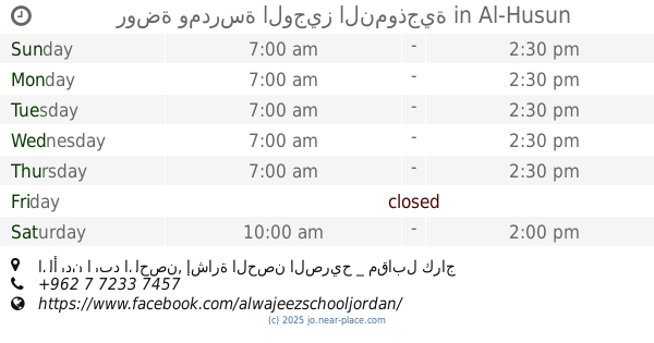
روضة ومدرسة الوجيز النموذجية
الأردن اربد الحصن, إشارة الحصن الصريح _ مقابل كراج القدس _ خلف صالون الأقصى, Al-Husun
School
read more
2.689 km
مدرسة الجسور
School
read more
2.706 km
مدارس الأحد الحديثة - Sunday modern school
School
read more
3.235 km
Mraas Academy
School
read more
3.38 km
Omar Al-Lafi High School for boys
25
School
read more
3.388 km
wasan academy,مركز وسن التخصصي للتوحد
School
read more
3.512 km
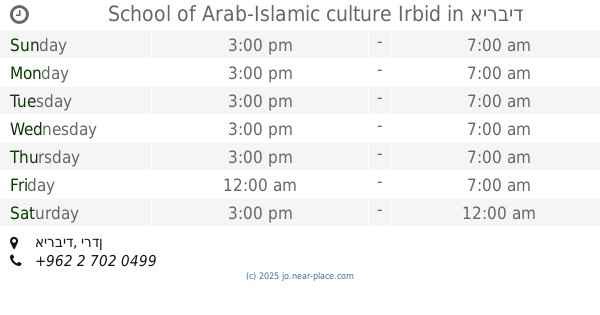
School of Arab-Islamic culture Irbid
School
read more
3.531 km
AICSK مدارس الثقافة العربية الاسلامية
School
read more
3.804 km
مدرسة الحصن المهنيه الثانوية للبنات
25
School
read more
3.804 km
International Grand Academy الاكديميه الكبرى الدوليه
Petra Street, Ramtha
School
read more
📑
all categories
Accounting
Administrative area level 1
Administrative area level 2
Airport
Amusement park
Aquarium
Art gallery
Atm
Bakery
Bank
Bar
Beauty salon
Bicycle store
Book store
Bowling alley
Bus station
Cafe
Campground
Car dealer
Car rental
Car repair
Car wash
Cemetery
Church
City hall
Clothing store
Colloquial area
Convenience store
Country
Courthouse
Dentist
Department store
Doctor
Electrician
Electronics store
Embassy
Finance
Fire station
Florist
Food
Funeral home
Furniture store
Gas station
General contractor
Grocery or supermarket
Gym
Hair care
Hardware store
Health
Home goods store
Hospital
Insurance agency
Jewelry store
Laundry
Lawyer
Library
Liquor store
Local government office
Locality
Locksmith
Lodging
Meal delivery
Meal takeaway
Mosque
Movie rental
Movie theater
Moving company
Museum
Natural feature
Neighborhood
Night club
Painter
Park
Parking
Pet store
Pharmacy
Physiotherapist
Place of worship
Plumber
Point of interest
Police
Post office
Premise
Real estate agency
Restaurant
Route
Rv park, camping
School
Shoe store
Shopping mall
Spa
Stadium
Storage
Store
Supermarket
Taxi stand
Train station
Travel agency
University
Veterinary care
Zoo
sublocality level 1
↑