School nearby مدرسة الآرين الحديثة
Jordan
School nearby مدرسة الآرين الحديثة
مدرسة الآرين الحديثة
Tourism Street, Iell Sub-District, Ma'an Governorate, JO Иордания
contacts phone
:
+962 7 7781 5208
Latitude:
31.6985816
, Longitude:
35.5816932
larger map & directions
read more
nearest School
12.443 km
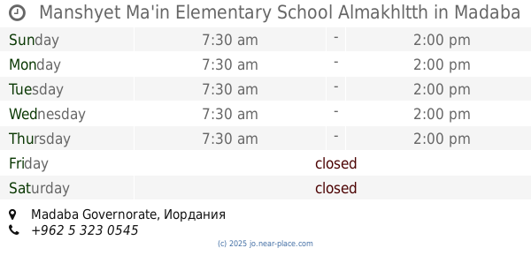
Manshyet Ma'in Elementary School Almakhltth
School
read more
13.469 km
college al quds
Al-Quds Street, Amman
School
read more
13.963 km
Ma'in Secondary School for Girls
School
read more
14.187 km
مدرسة ماعين الابتدائية للبنين
School
read more
14.281 km
مدرسة الرامة الثانوية الشاملة المختلطة
Al Rama
School
read more
14.377 km
Renaissance Secondary Comprehensive School for Boys
Balqa
School
read more
14.481 km
Al Nahda Secondary Comprehensive School for Girls
Balqa
School
read more
14.669 km
Ma'in Secondary School for Boys
School
read more
15.025 km
مدرسة الفيحاء للذكور
מידבא
School
read more
15.037 km
مدرسة الفيحاء للاناث
מידבא
School
read more
16.855 km
مدرسة الروضة الثانوية للاناث
Ar-Rawda
School
read more
17.072 km
مدرسة الروضة الاساسية للبنين
Ar-Rawda
School
read more
17.072 km
Al Rawdah Elementary School For Boys
Ar-Rawda
School
read more
19.197 km
مدرسة مادبا المهنية الثانوية الشاملةللبنات
Al-Imam Hasan Al-Banna Street, Madaba
School
read more
19.776 km
Secondary School Pulp
School
read more
20.551 km
Fatima Zahra Elementary School Mixed
Madaba
School
read more
21.872 km
Bandar School
Madaba
School
read more
23.018 km
Rashidiya Elementary School Mixed
School
read more
23.457 km
كلية الدفاع الوطني
Amman
School
read more
24.036 km
مدرسة السكنة
School
read more
25.982 km
مدارس الاخلاء
ناعور حسبان
School
read more
27.438 km
Um Alkotain Basic School Mixed
أم القطين،, Amman
School
read more
28.72 km
Khawla girl Azores Mansoura School
Maadaba Al-Gharbi Street, Amman
School
read more
30.04 km
Princess Tharwat High School for Girls
Amman
School
read more
32.483 km
مركز ايتام مرج الحمام
Amman
School
read more
📑
all categories
Accounting
Administrative area level 1
Administrative area level 2
Airport
Amusement park
Aquarium
Art gallery
Atm
Bakery
Bank
Bar
Beauty salon
Bicycle store
Book store
Bowling alley
Bus station
Cafe
Campground
Car dealer
Car rental
Car repair
Car wash
Cemetery
Church
City hall
Clothing store
Colloquial area
Convenience store
Country
Courthouse
Dentist
Department store
Doctor
Electrician
Electronics store
Embassy
Finance
Fire station
Florist
Food
Funeral home
Furniture store
Gas station
General contractor
Grocery or supermarket
Gym
Hair care
Hardware store
Health
Home goods store
Hospital
Insurance agency
Jewelry store
Laundry
Lawyer
Library
Liquor store
Local government office
Locality
Locksmith
Lodging
Meal delivery
Meal takeaway
Mosque
Movie rental
Movie theater
Moving company
Museum
Natural feature
Neighborhood
Night club
Painter
Park
Parking
Pet store
Pharmacy
Physiotherapist
Place of worship
Plumber
Point of interest
Police
Post office
Premise
Real estate agency
Restaurant
Route
Rv park, camping
School
Shoe store
Shopping mall
Spa
Stadium
Storage
Store
Supermarket
Taxi stand
Train station
Travel agency
University
Veterinary care
Zoo
sublocality level 1
↑