School nearby مدرسه البلاونه الثانويه
Jordan
School nearby مدرسه البلاونه الثانويه
مدرسه البلاونه الثانويه
Ajloun Governorate, ירדן
contacts phone
:
+962
Latitude:
32.241518
, Longitude:
35.6208653
larger map & directions
read more
nearest School
392 m
Amer bin Jarrah School
School
read more
588 m
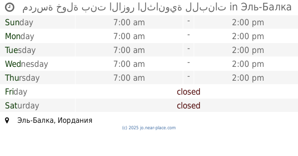
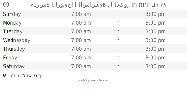
مدرسة البلاونه الاساسية للبنات
School
read more
779 m
مدرسة البلاونة الاساسية للبنين
School
read more
1.965 km
مدرسة خزما الاساسية للبنين
School
read more
2.076 km
مدرسة ذكور وإناث خزمة / الوكالة
لواء دير علا
School
read more
2.904 km
Decent Secondary School for Girls
School
read more
3.473 km
مدرسة خولة بنت الازور الثانوية للبنات
School
read more
3.48 km
Dirar bin Azwar School for Boys Secondary Comprehensive
School
read more
4.686 km
مدرسة الرويحا الاساسية للذكور
School
read more
4.776 km
مدرسة الرويحا الاساسية للاناث
School
read more
4.824 km
مدرسة رويحا الاساسية للبنات
School
read more
4.84 km
مدرسة ذكور كريمة الاعدادية
School
read more
4.85 km
مدرسة كريمة الثانوية للبنين
School
read more
5.433 km
Deir Alla Elementary School Mixed
School
read more
7.443 km
مسجد عبدالله بن عمر
School
read more
8.996 km
Directorate of Education Brigade Deir Alla
School
read more
9.708 km
مدرسة خديجه بنت خويلد الاساسيه المختلطه
Ajloun
School
read more
9.995 km
مدرسة المنصورة الثانوية المختلطه
School
read more
10.054 km
مدرسه عين البستان
Kufranjah
School
read more
14.616 km
Hashemite Secondary Girls School
Ajloun
School
read more
14.94 km
مدرسة جريش الاساسية المختلطة
Jordan
School
read more
15.026 km
مدرسه الملك الناصر
Ajloun
School
read more
15.372 km
مدرسة القلعة الاساسية المختلطة
Ajloun
School
read more
15.795 km
East Bayuda Secondery School for Girls
Jordan
School
read more
18.88 km
مدرسة الغفران
Balqa
School
read more
📑
all categories
Accounting
Administrative area level 1
Administrative area level 2
Airport
Amusement park
Aquarium
Art gallery
Atm
Bakery
Bank
Bar
Beauty salon
Bicycle store
Book store
Bowling alley
Bus station
Cafe
Campground
Car dealer
Car rental
Car repair
Car wash
Cemetery
Church
City hall
Clothing store
Colloquial area
Convenience store
Country
Courthouse
Dentist
Department store
Doctor
Electrician
Electronics store
Embassy
Finance
Fire station
Florist
Food
Funeral home
Furniture store
Gas station
General contractor
Grocery or supermarket
Gym
Hair care
Hardware store
Health
Home goods store
Hospital
Insurance agency
Jewelry store
Laundry
Lawyer
Library
Liquor store
Local government office
Locality
Locksmith
Lodging
Meal delivery
Meal takeaway
Mosque
Movie rental
Movie theater
Moving company
Museum
Natural feature
Neighborhood
Night club
Painter
Park
Parking
Pet store
Pharmacy
Physiotherapist
Place of worship
Plumber
Point of interest
Police
Post office
Premise
Real estate agency
Restaurant
Route
Rv park, camping
School
Shoe store
Shopping mall
Spa
Stadium
Storage
Store
Supermarket
Taxi stand
Train station
Travel agency
University
Veterinary care
Zoo
sublocality level 1
↑