School nearby Huwwarah High School
Jordan
School nearby Huwwarah High School
Huwwarah High School
Irbid, ירדן
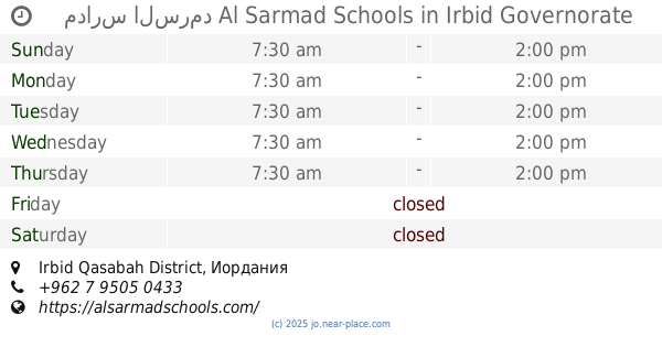
contacts phone
:
+962
Latitude:
32.5342023
, Longitude:
35.8911022
larger map & directions
read more
nearest School
8 m
Howarrah Males Secondary School
Irbid
School
read more
16 m
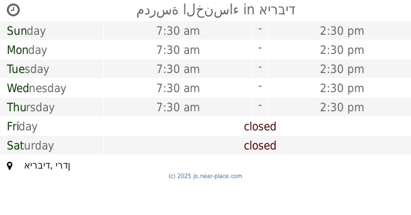
مدرسة حوارة الثانوية للبنين
Irbid
School
read more
691 m
مدرسة و روضة العرفان النموذجيه
Jordan
School
read more
712 m
School doors science of excellence
Irbid
School
read more
1.004 km
مدارس السرمد Al Sarmad Schools
Irbid Qasabah District
School
read more
1.006 km
مدارس السرمد Al Sarmad Schools
School
read more
1.029 km
Okath International School
Irbid
School
read more
1.034 km
Al Tatbikat School
10, Huwwarah
School
read more
1.241 km
Hippos Development And Training Center
Wasfi At-Tal St, Irbid
School
read more
1.34 km
مدرسة اليقين
Irbid
School
read more
1.376 km
yaqeen school
School
read more
1.433 km
المدرسة الريادية
School
read more
1.434 km
مدرسة الخنساء
School
read more
1.453 km
Pioneering School for Girls
Irbid
School
read more
1.484 km
مدارس تقارب ذكور
Irbid
School
read more
1.516 km
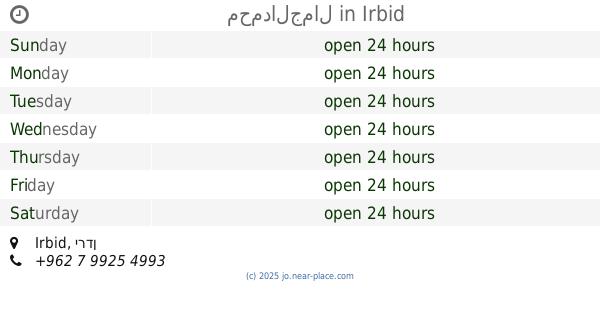
محمدالجمال
Irbid
School
read more
1.642 km
School
Al MAlik Husayn, Irbid
School
read more
1.684 km
مدارس اكاديمية القصور
School
read more
1.863 km
Sago Training & Education
Irbid
School
read more
2.028 km
Huwwara Quranic
Bilal Ben Rabah Street محافظة, Irbid
School
read more
2.08 km
shoaaa.alamal school مدرسة شعاع الامل
Almorad St, Elsssareh, Irbid
School
read more
2.144 km
School
Samar Street, Irbid
School
read more
2.422 km
اكاديمية اديسون النموذجية الدولية
Obeid District, Bani
School
read more
2.614 km
School
Muta, Irbid
School
read more
2.742 km
مسجد القدس اربد
Irbid
School
read more
📑
all categories
Accounting
Administrative area level 1
Administrative area level 2
Airport
Amusement park
Aquarium
Art gallery
Atm
Bakery
Bank
Bar
Beauty salon
Bicycle store
Book store
Bowling alley
Bus station
Cafe
Campground
Car dealer
Car rental
Car repair
Car wash
Cemetery
Church
City hall
Clothing store
Colloquial area
Convenience store
Country
Courthouse
Dentist
Department store
Doctor
Electrician
Electronics store
Embassy
Finance
Fire station
Florist
Food
Funeral home
Furniture store
Gas station
General contractor
Grocery or supermarket
Gym
Hair care
Hardware store
Health
Home goods store
Hospital
Insurance agency
Jewelry store
Laundry
Lawyer
Library
Liquor store
Local government office
Locality
Locksmith
Lodging
Meal delivery
Meal takeaway
Mosque
Movie rental
Movie theater
Moving company
Museum
Natural feature
Neighborhood
Night club
Painter
Park
Parking
Pet store
Pharmacy
Physiotherapist
Place of worship
Plumber
Point of interest
Police
Post office
Premise
Real estate agency
Restaurant
Route
Rv park, camping
School
Shoe store
Shopping mall
Spa
Stadium
Storage
Store
Supermarket
Taxi stand
Train station
Travel agency
University
Veterinary care
Zoo
sublocality level 1
↑